Report on Lopevi (Vanuatu) — June 2001

Bulletin of the Global Volcanism Network, vol. 26, no. 6 (June 2001)
Managing Editor: Richard Wunderman.
Lopevi (Vanuatu) 2000 activity documented in visit reports and sketch map
Please cite this report as:
Global Volcanism Program, 2001. Report on Lopevi (Vanuatu) (Wunderman, R., ed.). Bulletin of the Global Volcanism Network, 26:6. Smithsonian Institution. https://doi.org/10.5479/si.GVP.BGVN200106-257050
Lopevi
Vanuatu
16.507°S, 168.346°E; summit elev. 1413 m
All times are local (unless otherwise noted)
From 1963 to 1982 ash emissions, lava flows, lava fountains, and Strombolian explosions were intermittent. Eruptive activity resumed in July 1998. In December 1998, lava extruded but remained confined to the W-flank craters (BGVN 24:07). Sporadic eruptive activity again took place in March and October 1999. Ash clouds were noted through the end of April 2000 (BGVN 25:04).
This report focuses on field observations of activity during 2000. In mid-February 2000 a pyroclastic flow from the NW-flank crater traveled towards the W and was followed by a smaller debris avalanche that only extended ~250 m in length (BGVN 24:07).
July 2000 visit. A group visited Lopevi on 18-21 July 2000. The following was derived from reports provided by Sandrine Wallez, Douglas Charley, Roberto Carniel, Marco Fulle, and student Esline Garaebiti. Wallez and Charley's sketch map summarizes year 2000 activity (figure 11).
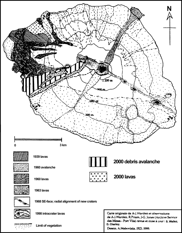 |
Figure 11. A sketch map of Lopevi emphasizing deposits during 1939-2000. Produced from an original map by A-J. Warden including observations by A-J. Warden and R. Priam (Archive Service de Mines); revised and updated by S. Wallez and D. Charley; drafted by A. Mabonlala. Courtesy of IRD. |
The July visitors observed significant deposits on the WSW flank (heavy slash pattern, figure 6) from the February 2000 activity. These visitors found few clear remnants of the pyroclastic-flow deposit. Instead the entire swath was overlain by a debris avalanche and possibly other mass-wasting deposits (figure 6).
Two lava flows came down the W-flank zone impacted by the pyroclastic flow and the debris avalanche. The area lies constrained by a near-vertical topographic discontinuity that reaches 800 m elevation.
The longer lava flow (N2) vented at the SE boundary of a 1963 crater. Overlying one of these lavas, the group found a field overlain by large bombs. The flow accumulated over the intracrater flow of December 1998, and moved in a westerly direction. Another smaller lava flow erupted nearer to the sea on the NW flank. Judging from the map, it reached the sea along a front ~1 km wide.
Geological Summary. The small 7-km-wide conical island of Lopevi, known locally as Vanei Vollohulu, is one of Vanuatu's most active volcanoes. A small summit crater containing a cinder cone is breached to the NW and tops an older cone that is rimmed by the remnant of a larger crater. The basaltic-to-andesitic volcano has been active during historical time at both summit and flank vents, primarily along a NW-SE-trending fissure that cuts across the island, producing moderate explosive eruptions and lava flows that reached the coast. Historical eruptions at the 1413-m-high volcano date back to the mid-19th century. The island was evacuated following major eruptions in 1939 and 1960. The latter eruption, from a NW-flank fissure vent, produced a pyroclastic flow that swept to the sea and a lava flow that formed a new peninsula on the western coast.
Information Contacts: Sandrine Wallez and Douglas Charley, Département de la Géologie, des Mines et des Resources en eau (IRD), Vanuatu; Roberto Carniel, Dipartmento di Georisorse e Territorio, Università di Udine, Via Cotonificio 114, 33100 Udine, Italy; Marco Fulle, Osservatorio Astronomico, Vai Tiepolo 11, 34131 Trieste, Italy.