Report on Lopevi (Vanuatu) — August 2001

Bulletin of the Global Volcanism Network, vol. 26, no. 8 (August 2001)
Managing Editor: Richard Wunderman.
Lopevi (Vanuatu) June 2001 lavas, debris avalanches, <= 1.5 m ashfall, and 7.5-km-high plume
Please cite this report as:
Global Volcanism Program, 2001. Report on Lopevi (Vanuatu) (Wunderman, R., ed.). Bulletin of the Global Volcanism Network, 26:8. Smithsonian Institution. https://doi.org/10.5479/si.GVP.BGVN200108-257050
Lopevi
Vanuatu
16.507°S, 168.346°E; summit elev. 1413 m
All times are local (unless otherwise noted)
Lopevi erupted explosively on 8 June 2001, with additional eruptions at least through the 19th. The current eruptive period, which started in July 1998, continued during 1999 and 2000 (BGVN 24:02, 24:07, 25:04, and 26:06). This report covers June and July 2001.
The explosive eruption that began around 1100 on 8 June generated an eruptive plume, a lava flow on the NW flank, and two debris avalanches on the W flank (figure 12). During the explosive activity, a crater opened at ~200 m elevation on the NW flank along the SE-NW crack. The ash plume rose to ~7,500 m (as determined by NOAA satellite data analysis). The ash blew NW, carried by ~35-45 km/hour winds; tephra-fall deposits on Lopevi reached ~0.5-1.5 m thick. As much as 7 cm of ash fell on the E coast and middle of Paama Island, 5 km WNW with ~1,700 residents, reaching a thickness of 7 cm.
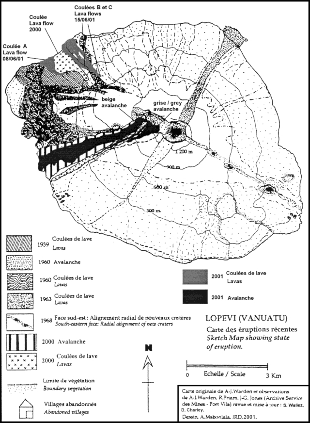 |
Figure 12. Sketch map of Lopevi showing the location of June 2001 deposits on the NW and NNW flanks. One lava flow and two debris avalanche deposits date from the 8 June 2001 eruption. Farther N, two lava flows date from the 15 June 2001 eruption. Produced from an original map by A-J. Warden including observations by A-J. Warden and R. Priam (Archive Service de Mines); revised and updated by S. Wallez and D. Charley; drafted by A. Mabonlala. Courtesy of IRD. |
About 11 hours after the eruption the Along-Track Scanning Radiometer (ATSR-2) research instrument on the European Remote-Sensing Satellite (ERS-2) obtained data from which an image of the plume could be derived (figure 13). The instrument has infrared detection channels at ~11 and ~12 µm, which are used to discriminate ash from meteorological clouds. The image shows the temperature difference between the 11 and 12 µm channels. The greater this negative difference, the greater the likelihood that there is ash; larger negative differences usually mean more ash. A possible explanation of the complex plume structure shown on figure 13 is the presence of atmospheric water vapor, which would mask the ash signal over some parts of the plume. Water vapor has the opposite effect of ash on the image: a positive difference is created because water vapor tends to make the 11µm temperature larger than the 12 µm temperature.
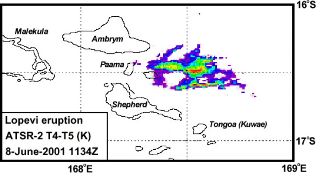 |
Figure 13. Lopevi ash plume as imaged by the ATSR-2 instrument on 8 June 2001 at 1134Z. The unlabeled island SW of the plume is Lopevi. The areas with the most ash are in the center of the shaded plume area. Courtesy of Fred Prata, CSIRO. |
The 8 June explosion caused instability on the W flank that produced two debris avalanches-unsorted deposits composed of older material (figures 14 and 15). The smaller of the two avalanches was composed of fine gray debris. It occurred next to the lava flow from the NW-flank crater. The larger avalanche, which reached the sea, was beige in color and included basaltic lava fragments, unburned vegetation, and red and black scoria of the sort commonly found on the steep (45°) upper slopes. The scoria and other observations were consistent with this debris avalanche resulting from a partial collapse of the active cone. Aa lava from the NW-flank crater spread out along the coastline (figure 14) on the SW side of the 2000 lava flows (figure 16). This flow had cooled by the time of a field visit on 11 June.
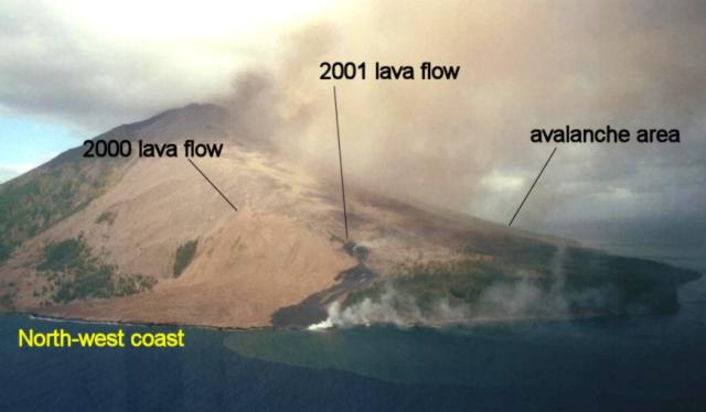 |
Figure 14. Lopevi's NW coastline showing the 8 June aa lavas and debris avalanches (barely visible); older lavas from 2000 also appear. The photograph was taken on 9 June 2001. Courtesy of S. Wallez. |
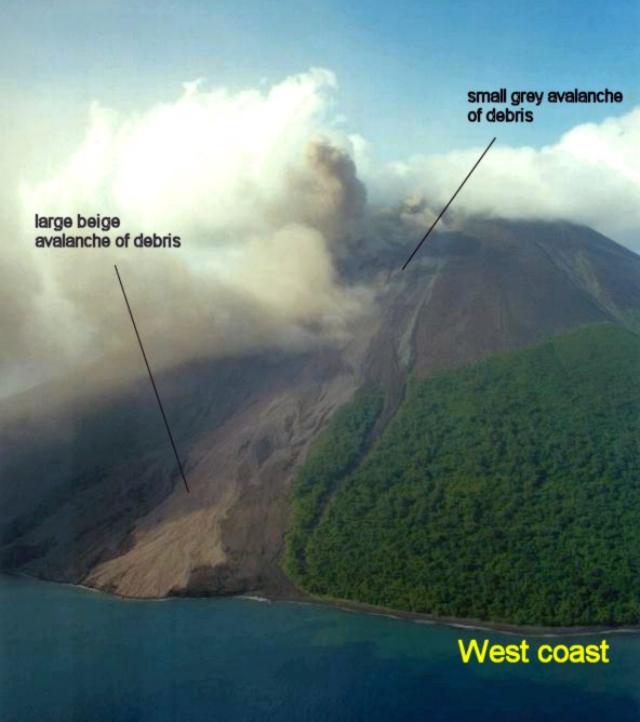 |
Figure 15. Lopevi's two W-flank debris avalanches produced during the 8 June 2001 eruption (photographed 9 June 2001). Courtesy of S. Wallez. |
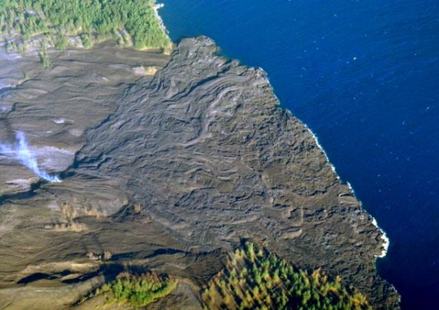 |
Figure 16. Sub-vertical aerial photograph showing lava flows that reached the NNW coast of Lopevi during 2000. Additional lava flows from the June 2001 eruptions covered parts of the SW and NE areas of this delta. N is to the right. Courtesy of S. Wallez. |
On a second visit during 14-17 June, geologists saw two new NW-flank flows, which they mapped and photographed (figures 12 and 17). Their guide said the lava flows were emplaced on 15 June 2001. These flows began at a height of ~400 m and added to a delta with a width of ~350 m at the coast.
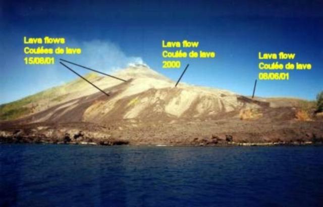 |
Figure 17. View of Lopevi from the ocean looking towards the NW coast towards the lava flows from 2000 and both 8 and 15 June 2001. Courtesy of S. Wallez. |
According to United Nations reports, the strong SE trade winds had deposited ~18 cm of ash on Paama Island as of 20 June, and lesser ashfall on Ambrym and Malekula islands. The worst affected villages were Luli, Lulep, and Liro on Paama. Overall, it was estimated that 4,000-5,000 people were directly affected by the ashfall on Paama and SE Ambrym. The ashfall on Paama polluted open water-supplies, bringing the pH to 3-4, and caused darkness for a few hours beginning at about 1500 on 8 June. The 12 June report noted that the government of Vanuatu had approached the Australian High Commission in Port Vila and in response an Australian ship in the area, HMAS Kanimbla, was deployed to deliver drinking water from Red Cross stocks. The Vanuatu Red Cross Society provided water, blankets, and soap, as well as participating in assessment activities with government officials and scientists. The National Disaster Management Office reported to the UN that more ashfall occurred on the night of 19 June. As of 20 June sources of potable water had been identified, but there remained a shortage of cooking and wash water. As a precaution, 105 students and five teachers from Paama were evacuated to schools on other islands, but most residents remained and were occupied with clearing ash from roofs, water tanks, and gardens.
Geological Summary. The small 7-km-wide conical island of Lopevi, known locally as Vanei Vollohulu, is one of Vanuatu's most active volcanoes. A small summit crater containing a cinder cone is breached to the NW and tops an older cone that is rimmed by the remnant of a larger crater. The basaltic-to-andesitic volcano has been active during historical time at both summit and flank vents, primarily along a NW-SE-trending fissure that cuts across the island, producing moderate explosive eruptions and lava flows that reached the coast. Historical eruptions at the 1413-m-high volcano date back to the mid-19th century. The island was evacuated following major eruptions in 1939 and 1960. The latter eruption, from a NW-flank fissure vent, produced a pyroclastic flow that swept to the sea and a lava flow that formed a new peninsula on the western coast.
Information Contacts: Sandrine Wallez and Douglas Charley, Department of Geology, Mines & Water Resources (DGMWR), PMB 01, Port-Vila, Vanuatu; Michel Lardy, Institut de Recherche pour le Développement (IRD), Bondy, Paris, France; Fred Prata, Senior Principal Research Scientist, Commonwealth Scientific and Industrial Research Organization (CSIRO), Atmospheric Research, PB 1 Aspendale, Victoria 3195, Australia; United Nations Office for the Coordination of Humanitarian Affairs (OCHA), New York, NY 10017 USA (URL: https://reliefweb.int/).