Report on Colima (Mexico) — February 2002

Bulletin of the Global Volcanism Network, vol. 27, no. 2 (February 2002)
Managing Editor: Richard Wunderman.
Colima (Mexico) Growth of the lava dome at the end of 2001 spawning new lava flows
Please cite this report as:
Global Volcanism Program, 2002. Report on Colima (Mexico) (Wunderman, R., ed.). Bulletin of the Global Volcanism Network, 27:2. Smithsonian Institution. https://doi.org/10.5479/si.GVP.BGVN200202-341040
Colima
Mexico
19.514°N, 103.62°W; summit elev. 3850 m
All times are local (unless otherwise noted)
A new lava flow began on 14 February 2002 on the SW flank of the central crater of Volcán de Colima (figure 46). On 22 February 2002, the flow was 200 m long and had a volume of ~720,000 m3. The rate of magma extrusion at the surface was ~0.9 m3/s. The lava flow emerged from the summit lava dome after the dome had filled the crater in early February (figure 47). Starting on the evening of 4 February, frequent incandescent avalanches descended along the SW, S, and W slopes and into the ravines of La Lumbre, El Zarco, Cordoban and San Antonio and preceded the lava flows. The number and intensity of the rockfalls increased rapidly (figure 48). Rocks traveled as far as 1-3 km from the crater. Pyroclastic flows reached 1-2 km in length on 9 February; they descended the S and SW flanks.
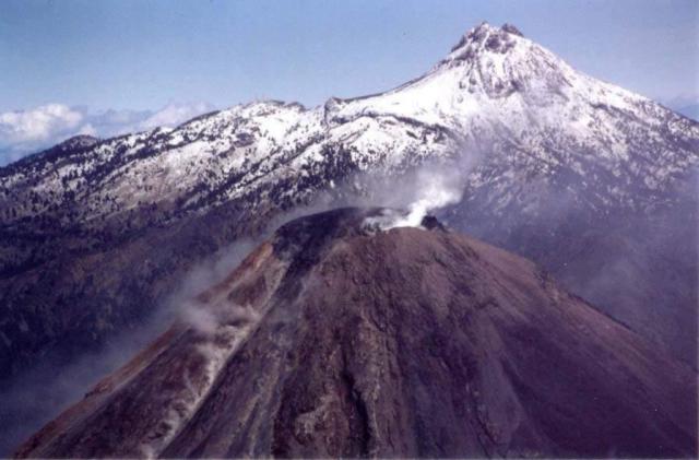 |
Figure 46. A N-looking aerial photo taken on 14 February 2002 shows the upper slopes of Volcan de Colima (foreground) and the snow-covered cone of Nevado de Colima (background). Colima's lava dome appears as a dark mass filling the crater and bulging upwards; a dense plume of white steam hangs over the eastern summit. Elongate plumes emerge from lava flows and avalanches coming off the dome and descending radially oriented chutes (left center). This photo was taken by M. Breton. Courtesy of Observatorio Vulcanológico de la Universidad de Colima. |
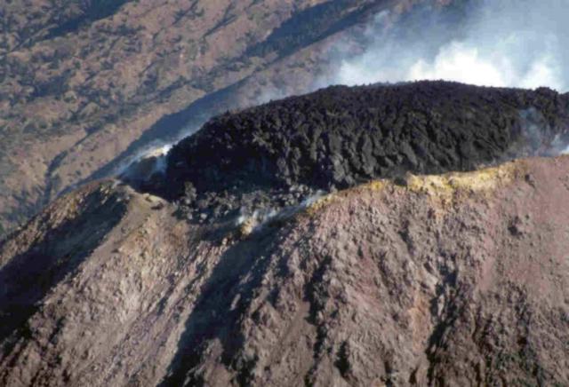 |
Figure 47. A photo of Volcan de Colima taken on 5 February showing the lava dome filling and capping the summit. Lava flows began about 9 days later (see previous figure). The photographer was M. Breton. Courtesy of Observatorio Vulcanológico de la Universidad de Colima. |
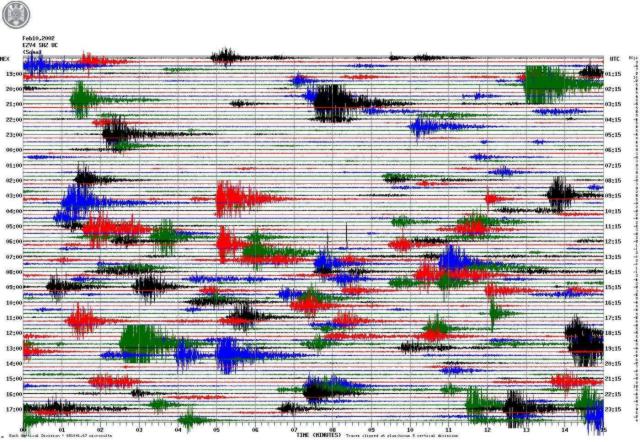 |
Figure 48. A seismogram recorded at station Soma (EZV4), which is located 1.7 km NW from the Colima crater. The sporadic, impulsive events shown on this record of 10 February 2002 were produced by rockfalls and pyroclastic flows. Courtesy of Red Sismológico RESCO, Observatorio Vulcanológico de la Universidad de Colima. |
With the beginning of intensive rockfalls in early February, the authorities of Colima State evacuated the nearest village, La Yerbabuena, which is located 8 km S of the crater. About 200 persons evacuated during 5-11 February. During the remainder of February and into March, landslides and incandescent avalanches continued to travel down the S, SW and W flanks, extending 2-3 km from the summit. Dark block lava was also seen, flowing down the E, W, and SW flanks and extending as far as 2 km from the summit.
The lava dome began to grow slowly at the beginning of May 2001 (BGVN 26:05). At the end of October, a spine-type extrusion, 60 m high, formed on the N part of the dome (BGVN 26:10). It was destroyed one month later. Around that time, the situation changed as the lava extrusion rate increased from 0.05 to 1.0 m3/s and lava began to fill the crater. The rate of magma extrusion increased sharply in October 2001 (figure 49), and by the end of January 2002, the total volume of the dome was estimated as 1,450,000 m3. The increased rate of dome growth occurred during a period of very low seismicity accompanied by a continuous deformation of the volcano's surface. This deformation was interpreted as inflation that could reflect the injection of new magma at depth.
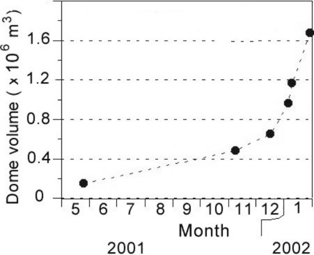 |
Figure 49. The history of Colima dome growth in 2001-2002. The volumes were estimated from air photos. Courtesy of Observatorio Vulcanológico de la Universidad de Colima. |
Geological Summary. The Colima complex is the most prominent volcanic center of the western Mexican Volcanic Belt. It consists of two southward-younging volcanoes, Nevado de Colima (the high point of the complex) on the north and the historically active Volcán de Colima at the south. A group of late-Pleistocene cinder cones is located on the floor of the Colima graben west and east of the complex. Volcán de Colima (also known as Volcán Fuego) is a youthful stratovolcano constructed within a 5-km-wide scarp, breached to the south, that has been the source of large debris avalanches. Major slope failures have occurred repeatedly from both the Nevado and Colima cones, producing thick debris-avalanche deposits on three sides of the complex. Frequent recorded eruptions date back to the 16th century. Occasional major explosive eruptions have destroyed the summit (most recently in 1913) and left a deep, steep-sided crater that was slowly refilled and then overtopped by lava dome growth.
Information Contacts: Observatorio Vulcanológico de la Universidad de Colima, Universidad de Colima, Ave. 25 de Julio 965, Colima 28045, Colima, México.