Report on Colima (Mexico) — May 2002

Bulletin of the Global Volcanism Network, vol. 27, no. 5 (May 2002)
Managing Editor: Richard Wunderman.
Colima (Mexico) New lava flows; change in deformation during 15-20 May 2002 prompts evacuation
Please cite this report as:
Global Volcanism Program, 2002. Report on Colima (Mexico) (Wunderman, R., ed.). Bulletin of the Global Volcanism Network, 27:5. Smithsonian Institution. https://doi.org/10.5479/si.GVP.BGVN200205-341040
Colima
Mexico
19.514°N, 103.62°W; summit elev. 3850 m
All times are local (unless otherwise noted)
New lava flows began on 14 February 2002 on the SW flank of the central crater of Colima. The lava flows were produced by the dome that had filled the crater through early February (BGVN 27:02). Figures 50 and 51 show the dome at the end of May 2002. Two main groups of lava flows were formed; the first was a flow with a maximum length of 1,400 m, and the second included two small branches with maximum lengths of 500 m (table 11). The total volume of lava reached 3,435,000 m3. Emplacement of the lava flows was accompanied by numerous incandescent rockfalls on the SW, S, and W slopes of the volcano along the ravines of La Lumbre, El Zarco, Cordoban, and San Antonio beginning on the evening of 4 February. The first pyroclastic flows of 1-2 km length were recorded on 9 February on the S and SW flanks, prior to the onset of the new lava flows. The number and intensity of the rockfalls and pyroclastic flows increased rapidly and from 15 February were recorded at a level of 200-300 per day through April (figure 52). Rockfalls reached a distance of 1-3 km from the crater.
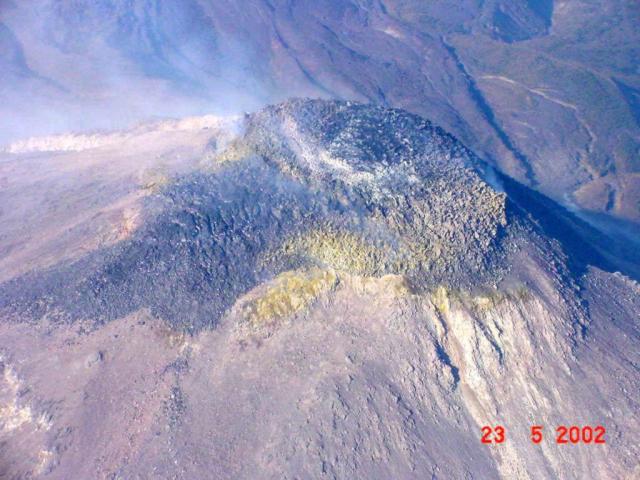 |
Figure 50. A S-looking view of the summit of Colima taken on 23 May 2002 showing the emerging dome dominating the summit area. Lava flows appeared to emerge from the dome. Courtesy of Secretaria de Comunicaciones y Transportes del estado de Colima. |
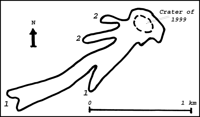 |
Figure 51. A sketch of the new lava flows on the W and SW slope of Colima at the end of May 2002. Courtesy of Observatorio Vulcanológico de la Universidad de Colima. |
Table 11. Characteristics of the 2002 lava flows 1 and 2 of Colima (see figure 2). "--" indicates that the information was not reported. Courtesy of Observatorio Vulcanológico de la Universidad de Colima.
| Date | Flow 1 Length | Flow 1 Volume | Flow 1 Effusion rate | Flow 2 Length | Flow 2 Volume | Flow 2 Effusion rate |
| 22 Feb 2002 | 200 m | 720,000 m3 | 6-9 m3/s | -- | -- | -- |
| 22 Mar 2002 | 550 m | 1,650,000 m3 | 0.6 m3/s | -- | -- | -- |
| 26 Apr 2002 | 1,000 m | 1,785,000 m3 | 0.07 m3/s | 50 m | 98,000 m3 | -- |
| 30 May 2002 | 1,400 m | 2,310,000 m3 | 0.2 m3/s | 500 m | 1,125,000 m3 | 0.3 m3/s |
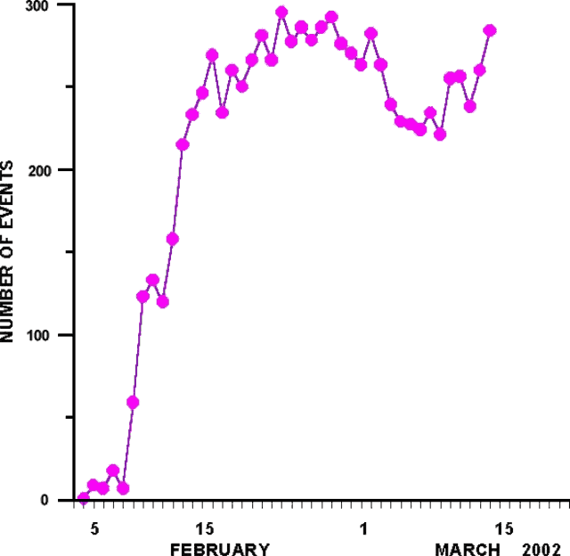 |
Figure 52. Daily variations of the number of rockfalls and pyroclastic flows recorded by seismic station Soma at a distance of 1.7 km from the crater of Colima. Courtesy of Observatorio Vulcanológico de la Universidad de Colima. |
The Washington VAAC reported that ash and steam were observed on 8 March extending E from Colima at 4.3-5.2 km altitude. The emission was too small to be visible on satellite imagery, although a faint hotspot was seen in shortwave imagery. On 25 March at 1040 a steam-and-ash emission rose to ~5-6 km altitude and drifted E.
On 25 March volcanic tremor began to occur during 1- to 3-hour intervals, and since 8 April tremor was observed daily for intervals from a few minutes to 10 hours. Degassing occurred starting on 25 April as very low-magnitude explosions. In many cases, the intervals of volcanic tremor were accompanied by an explosive event. The numerous but very small-amplitude tremor and explosive events occurred simultaneously and accompanied continuous records of rockfalls and pyroclastic flows.
Deformation of the volcanic edifice that was observed by an inclinometer network showed a sharp change in behavior on 15 May. On 20 May deformation became stable. A preventive evacuation of the village of La Yerbabuena occurred during 18 May-4 June. The 6.5-km-radius zone of exclusion around Colima remained in effect, with other restricted access continuing out to a radius of 11.5 km.
Geological Summary. The Colima complex is the most prominent volcanic center of the western Mexican Volcanic Belt. It consists of two southward-younging volcanoes, Nevado de Colima (the high point of the complex) on the north and the historically active Volcán de Colima at the south. A group of late-Pleistocene cinder cones is located on the floor of the Colima graben west and east of the complex. Volcán de Colima (also known as Volcán Fuego) is a youthful stratovolcano constructed within a 5-km-wide scarp, breached to the south, that has been the source of large debris avalanches. Major slope failures have occurred repeatedly from both the Nevado and Colima cones, producing thick debris-avalanche deposits on three sides of the complex. Frequent recorded eruptions date back to the 16th century. Occasional major explosive eruptions have destroyed the summit (most recently in 1913) and left a deep, steep-sided crater that was slowly refilled and then overtopped by lava dome growth.
Information Contacts: Observatorio Vulcanológico de la Universidad de Colima, Ave. 25 de Julio 965, Colima 28045, Colima, México; Washington Volcanic Ash Advisory Center (VAAC), NOAA/NESDIS Satellite Analysis Branch, Room 401, 5200 Auth Road, Camp Springs, MD 20746, USA (URL: http://www.ospo.noaa.gov/Products/atmosphere/vaac/).