Report on Witori (Papua New Guinea) — July 2002
Bulletin of the Global Volcanism Network, vol. 27, no. 7 (July 2002)
Managing Editor: Richard Wunderman.
Witori (Papua New Guinea) Early August ash eruptions; > 6,000 people evacuated; new lava cones
Please cite this report as:
Global Volcanism Program, 2002. Report on Witori (Papua New Guinea) (Wunderman, R., ed.). Bulletin of the Global Volcanism Network, 27:7. Smithsonian Institution. https://doi.org/10.5479/si.GVP.BGVN200207-252080
Witori
Papua New Guinea
5.5745°S, 150.5161°E; summit elev. 724 m
All times are local (unless otherwise noted)
A new eruption began at Pago on 3 August 2002. Although there were three eruptions from Pago in the 20th century (1911, 1920 ± 2 years, and 1933), fumarolic emissions were last reported during September 1990. At 1440 on 3 August 2002, Qantas Airlines reported a rapidly rising ash cloud at 9.1 km altitude. The summit was obscured by clouds, and ash was not identifiable from satellite data. At 0705 on 5 August Air Niugini reported another ash cloud that was 18 km wide at 1.2 km altitude extending 37 km NW. This plume was from an eruption that began, according to press reports, around 0530 on 5 August. By 0600, residents in Hoskins and Kimbe towns realized there had been a volcanic eruption when they saw thick clouds of ash drifting W across Kimbe Bay. Another eruption occurred about midday, depositing ash on Hoskins. Earthquakes were felt before the eruption.
Air Niugini reported that at 0630 on 6 August a 1.8- to 2.4-km-thick gray ash plume extended 148 km WNW at 7.6 km altitude. The Rabaul Volcano Observatory (RVO) noted that at 0830 the ash column had reached 10 km above the volcano. A low-level ash plume identified on GMS visible satellite imagery at 0932 extended 111 km WNW with a width of 18 km. By 1132 the ash plume was 37 km wide based on visible satellite imagery. The RVO reported that eruptions were continuing at 1800 on 6 August with the ash plume moving NNW to N.
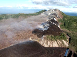
According to news articles, 6,000-8,000 people had been evacuated from villages surrounding the volcano by 9 August. No injuries had been reported. RVO reported that the eruption was characterized by the ejection of light gray to dark ash clouds. The clouds drifted primarily N and NW, after reaching heights of a few kilometers above the summit. Very little ash was deposited in areas surrounding the volcano. The thickest ashfall (3 mm) occurred at Rikau and Matmada, 6-8 km NNW of the volcano (figure 1). There was not more than 1 mm of ash deposited at Hoskins airport. Aerial inspection of the summit area by RVO staff indicated that there were no lava flows descending the volcano's flanks. Instead, lava extruded onto the surface formed cones above the active vents. The highest cone was about 60 m tall. Contrary to previous reports, there was no bulging on the N or NW sides of the volcano. Seismicity was at low-to-moderate levels. The closure of the airport near the town of Kimbe, ~48 km N of Pago, disrupted island air traffic.
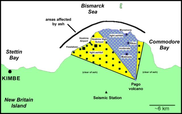 |
Figure 1. Ashfall from Pago during the August 2002 eruption. The distribution was heaviest towards the NNW (cross-hatched pattern), lighter towards the W (squares pattern). Courtesy RVO. |
On 13 August at 1030 a thin plume was visible on satellite imagery to a height of ~2.1 km and extending N to NW. The summit was cloud-covered, preventing visual observations. Only weak intermittent rumbling was heard.
Geological Summary. The active Pago cone has grown within the Witori caldera (5.5 x 7.5 km) on the northern coast of central New Britain contains the active Pago cone. The gently sloping outer caldera flanks consist primarily of dacitic pyroclastic-flow and airfall deposits produced during a series of five major explosive eruptions from about 5,600 to 1,200 years ago, many of which may have been associated with caldera formation. Pago cone may have formed less than 350 years ago; it has grown to a height above the caldera rim, and a series of ten dacitic lava flows from it covers much of the caldera floor. The youngest of these was erupted during 2002-2003 from vents extending from the summit nearly to the NW caldera wall. The Buru caldera cuts the SW flank.
Information Contacts: Ima Itikarai, Rabaul Volcano Observatory (RVO), PO Box 386, Rabaul, E.N.B.P., Papua New Guinea; Darwin Volcanic Ash Advisory Center (VAAC), Bureau of Meteorology, Northern Territory Regional Office, PO Box 40050, Casuarina, NT 0811, Australia (URL: http://www.bom.gov.au/info/vaac/); Reuters; Associated Press.