Report on Fuego (Guatemala) — August 2002

Bulletin of the Global Volcanism Network, vol. 27, no. 8 (August 2002)
Managing Editor: Richard Wunderman.
Fuego (Guatemala) Explosions, ash emission, and lava flows during January-February and July 2002
Please cite this report as:
Global Volcanism Program, 2002. Report on Fuego (Guatemala) (Wunderman, R., ed.). Bulletin of the Global Volcanism Network, 27:8. Smithsonian Institution. https://doi.org/10.5479/si.GVP.BGVN200208-342090
Fuego
Guatemala
14.473°N, 90.88°W; summit elev. 3763 m
All times are local (unless otherwise noted)
On 4 January 2002, an eruption began at Fuego during 0200-0300. A probable explosion was followed by Strombolian-type ejections and continuous tremor, but no lava flows were visible. Intermittent mild-to-moderate explosions continued during the next few days, producing ash clouds that rose 400-600 m.
In late January, Fuego continued to erupt a lava flow down its E flank. The flow stretched several hundred meters below the summit before falling apart on steep slopes. The toe of the flow calved off about once a minute, but the volume of material was not sufficient to generate pyroclastic flows. Minor amounts of ash were kicked up when the front flow calved. Incandescence from the flow front was visible from Antigua. No explosive activity was observed and only low-level tremor was recorded. A generally white plume was observed.
Based on information provided by Instituto Nacional de Sismologia, Vulcanologia, Meteorologia e Hidrologia (INSIVUMEH), the Washington VAAC reported that on 1 February at 0930 ash, steam, and lava were emitted from Fuego. An ash-and-steam cloud rose to ~4.5 km altitude and drifted to the SW. No ash was seen on satellite imagery, but a hotspot was visible on infrared imagery. News reports stated that as of 10 February the increase in earthquakes and gas emissions at Fuego led Coordinadora Nacional para la Reducción de Desastres (CONRED) to declare Alert Level Yellow for the departments of Chimaltenango, Sacatepéquez, and Escuintla. On 10 February INSIVUMEH reported that more than 400 explosions occurred at Fuego in comparison to the ~75 daily explosions that had normally occured in the recent past. During the evening, incandescent lava was seen flowing down the volcano's S flank.
Volcanism increased at Fuego on 12 February, with a ~2-km-long lava flow streaming down its flank towards an unpopulated area. Several shelters were set up in the event that the lava flows traveled towards populated areas or if volcanism increased.
A new cycle of eruptive activity began at Fuego on 16 July that consisted of an increase in Strombolian explosions and the occurrence of high-frequency volcanic tremor for 24 hours. On 28 July a thick gray ash cloud drifted 10-15 km to the W. Ash was deposited in the areas of Rochela, Panimaché, Morelia, Santa Sofía, and to the W in Yepocàpa, Chimaltenango. This activity was associated with a collapse of the front of the lava flow in the Las Lajas drainage, which began on 23 January.
On the evening of 29 July the FG3 station registered an increase in seismicity (particularly in continuous tremor) during a 24-hour period. The intensity of the explosions in the crater also increased, and the lava flow reached 2-3 km in length. Early on 2 August the explosions became more vigorous, changed from Strombolian to Vulcanian, and ash columns rose 800-1,400 m above the crater. A column of fine ash extended 4 km W.
Beginning on 2 August, the emanation of gases from the crater diminished considerably, and the SE lava flow decreased in length. COSPEC measurements on the same day revealed that SO2 was at moderate levels (394 metric tons), and had increased since measurements taken on 18 June (319 metric tons) (table 1). RSAM data showed an increase in activity during 26 July-3 August, when values peaked at ~675 RSAM units. After 3 August, RSAM values gradually decreased, reaching a value of ~375 RSAM units by 9 August. In the villages of Panimaché (4 km SW) and Zapote (SE flank) a decrease in water levels coincided with increased fumarole activity and frequency of volcanic tremor.
Table 1. SO2 fluxes at Fuego during January-August 2002. Courtesy Lizzette A. Rodriguez, William Rose, Matthew Watson, Yvonne Branan, Gregg Bluth (MTU), Simon Carn (University of Maryland Baltimore County), and Gustavo Chigna and Otoniel Matías (INSIVUMEH).
| Date | SO2 emission rate (tons/day) |
| 07 Jan 2002 | 223.5 |
| 14 Jan 2002 | 330.2 |
| 02 Feb 2002 | 248.7 |
| 15 Feb 2002 | 364.9 |
| 19 Feb 2002 | 356.4 |
| 01 Mar 2002 | 512.4 |
| 06 Mar 2002 | 652.6 |
| 22 Mar 2002 | 823.0 |
| 17 Apr 2002 | 464.9 |
| 19 Apr 2002 | 587.9 |
| 18 Jun 2002 | 318.5 |
| 02 Aug 2002 | 394.0 |
| 20 Aug 2002 | 216.1 |
"Kiwi" Bhatia reported that Fuego erupted almost continuously during 17-23 July. He estimated that the lava flow advanced 30 m or more. Pyroclasts tumbled down the flanks. Strong rumblings during 10-21 August were loud enough to be heard from neighboring farms.
According to Glyn Williams-Jones (HIGP/SOEST), GOES hot-spot monitoring may indicate a potential cyclical nature to thermal activity observed at the volcano. In order to facilitate and automate GOES monitoring, a new comparison technique developed by Wright and others (in review) is being tested. A correlation term (R2) compares the peak radiance of a given pixel with the mean background radiance. Changes in activity can be recognized due to their sudden lack of correlation. This technique can be illustrated by the poor correlation (R2 significantly less than 0.9) for the 28 July and 2 August ash emissions (figure 4). From August 19 onwards, activity appears to have returned to "background" levels (i.e., R2 greater than 0.9).
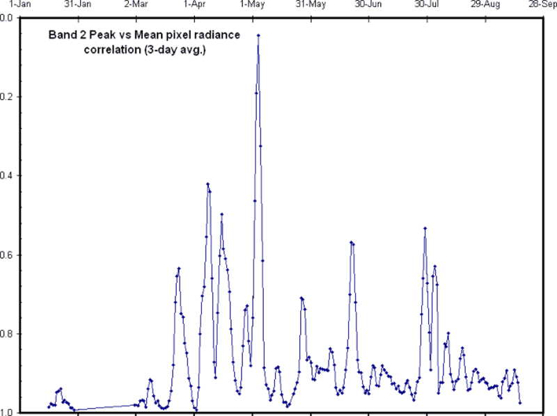 |
Figure 4. A plot showing R-squared correlation values (y-axis) versus date (x-axis) at Fuego during January through mid-August 2002. The correlation values (R2) compare band 2 peak vs. mean pixel radiance. Perfect correlation (R2 = 1.0) suggests non-eruptive conditions, decreased correlation (R2 significantly less than 0.9) suggests possible eruptions. In other words, the peaks on this plot suggest eruptive conditions. Courtesy HIGP/SOEST. |
Jacquelyn Gluck reported that visual observation during the afternoon of 25 August and at night on 26 August revealed no activity. No incandescence was seen by observers on high points in Antigua looking to the SW.
Reference. Wright, R., Flynn, L.P., Garbeil, H., Harris, A.J.L., and Pilger, E., 2002, MODVOLC: near-real-time thermal monitoring of global volcanism: JVGR, in review.
General Reference. Chesner, C.A. and Rose, W.I., 1984, Geochemistry and Evolution of the Fuego Volcanic Complex, Guatemala; JVGR, v. 21, p. 25-44.
Geological Summary. Volcán Fuego, one of Central America's most active volcanoes, is also one of three large stratovolcanoes overlooking Guatemala's former capital, Antigua. The scarp of an older edifice, Meseta, lies between Fuego and Acatenango to the north. Construction of Meseta dates back to about 230,000 years and continued until the late Pleistocene or early Holocene. Collapse of Meseta may have produced the massive Escuintla debris-avalanche deposit, which extends about 50 km onto the Pacific coastal plain. Growth of the modern Fuego volcano followed, continuing the southward migration of volcanism that began at the mostly andesitic Acatenango. Eruptions at Fuego have become more mafic with time, and most historical activity has produced basaltic rocks. Frequent vigorous historical eruptions have been recorded since the onset of the Spanish era in 1524, and have produced major ashfalls, along with occasional pyroclastic flows and lava flows.
Information Contacts: Gustavo Chigna M. and Otoniel Matías, Instituto Nacional de Sismologia, Vulcanologia, Meteorologia e Hidrologia (INSIVUMEH), Ministero de Communicaciones, Transporto, Obras Públicas y Vivienda, 7a. Av. 14-57, zona 13, Guatemala City 01013, Guatemala (URL: http://www.insivumeh.gob.gt/); Juan Pablo Ligorria, Coordinadora Nacional para la Reducción de Desastres (CONRED), Av. Hincapié 21-72, Zona 13, Guatemala City, Guatemala; William Rose, Matt Watson, Yvonne Branan, Lizzette Rodríguez, and Gregg Bluth, Michigan Technological University, Houghton, MI 49931, USA; Glyn Williams-Jones, HIGP/SOEST, University of Hawaii at Manoa,1680 East-West Road, Post 602, Honolulu, HI 96822, USA; Simon Carn, TOMS Volcanic Emissions Group, Joint Center for Earth Systems Technology (NASA/UMBC), University of Maryland, Baltimore County, 1000 Hilltop Circle, Baltimore, MD 21250, USA; John W. Ewert and Randy White, U.S. Geological Survey, Volcano Disaster Assistance Program, 5400 MacArthur Blvd., Vancouver, WA 98661, USA (URL: http://volcanoes.usgs.gov/); Washington Volcanic Ash Advisory Center, NOAA Satellite Services Division, NESDIS E/SP23, NOAA Science Center, Room 401, 5200 Auth Road, Camp Springs, MD 20746, USA (URL: http://www.ospo.noaa.gov/Products/atmosphere/vaac/); United Nations Office for the Coordination of Humanitarian Affairs (OCHA), United Nations, New York, NY 10017, USA (URL: https://reliefweb.int/); Jim Vallance, McGill University, Department of Civil Engineering & Applied Mathematics, 817 Sherbrooke Street West, Montreal, Quebec H3A 2K6, Canada; Rafael W. Rodriguez, U.S. Geological Survey, c/o American Embassy, Avenida Reforma 7-01 Zona 10, Ciudad Guatemala 01010, Guatemala; D.M.S. Bhatia, Department of Geology, Austin Peay State University, Clarksville, TN 37044, USA; Jacquelyn Gluck, Global Volcanism Program, Smithsonian Institution, Washington, DC 20560-0119, USA; The Clinton Courier, Prensa Libre, Associated Press.