Report on Witori (Papua New Guinea) — September 2002
Bulletin of the Global Volcanism Network, vol. 27, no. 9 (September 2002)
Managing Editor: Richard Wunderman.
Witori (Papua New Guinea) Continued lava flows and deformation; monitoring network installed
Please cite this report as:
Global Volcanism Program, 2002. Report on Witori (Papua New Guinea) (Wunderman, R., ed.). Bulletin of the Global Volcanism Network, 27:9. Smithsonian Institution. https://doi.org/10.5479/si.GVP.BGVN200209-252080
Witori
Papua New Guinea
5.5745°S, 150.5161°E; summit elev. 724 m
All times are local (unless otherwise noted)
The eruption that began at Pago on 3 August with significant ash plumes (BGVN 27:07) had produced lava flows from multiple vents NW of the main crater by early September (BGVN 27:08). This report provides additional details of fieldwork by the Japanese Disaster Relief Team noted in the last issue. Varied information from a United Nations report on 27 September has been distributed into appropriate sections below.
Observations of recent activity. The United Nations reported on 27 September that the volcano continued to emit steam and a thin vapor plume from vents near the summit and that the plume drifted to the NW over the Hoskins Peninsula. Lava continued to flow into the wider Witori Caldera basin, but was contained by its wall. Low-level seismicity and slow ground deformation along the W part of the caldera floor also continued. Monitoring about 3 km SW of the summit has shown a slight uplift.
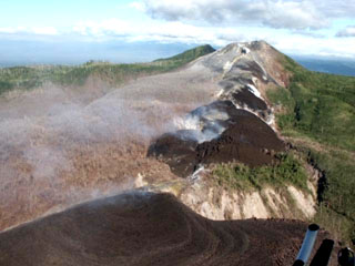
While enroute from Kavieng to Port Moresby, Dave Innes (acting First Officer of an Air Niugini Fokker F-28, Captain Alex Porter in command) photographed Pago around 1230 on 14 September from an altitude of about 8.5 km (28,000 feet) while the volcano was quiet (figure 5). Later in the month Innes noted that the volcano had been putting out little more than "smoke," but on the 30th he and Captain Seymour (another Air Niugini F-28 commander) put in an "ash-sighting chit" when they saw that it was fairly active. He reports that the "smoke" stayed over the whole center section of the N coast of New Britain through to the following day (1 October).
 |
Figure 5. Aerial photograph of Pago around 1230 on 14 September 2002. Dark lava flows can be seen extending NNW from the crater towards the upper center of the view. The lighter-colored fan-shaped area in the center (N of the crater) is most likely ash-covered vegetation; previous ash plumes blew in that direction. Courtesy of David Innes, Air Niugini. |
The "ash-sighting chit" noted by Innes is an internal Air Niugini Volcanic Volcanic Activity Report. This is a company variation of the ICAO VAR (section one) which is separate from the formal reporting process. Crews transitting known hot-spots fill out the form, rip off the white copy (which looks like a receipt or "chit" ), and put it in a box at crewing in Port Moresby. Pilots arriving to commence flights can then see what their colleagues had seen the last time someone passed that way.
Volcano monitoring. As noted in the UN report, the assistance of technical teams from Japan and the United States was achieved through the efforts of the Rabaul Volcanological Observatory from East New Britain, which is overseeing scientific efforts. The government of Papua New Guinea (PNG) has set up a Kimbe Volcanological Observatory to coordinate the scientific work on Pago, and ultimately to monitor and evaluate the threat posed by West New Britain's three other active volcanoes.
Installing a volcanic monitoring system on Pago had been long-planned as part of a cooperative program between the U.S. Geological Survey's Volcano Disaster Assistance Program (VDAP), with funding from the Office of Foreign Disaster Assistance, and Geoscience Australia to provide assistance to PNG. However, the current eruption accelerated those plans. On 5 September, at the invitation of the PNG government a 3-person team from VDAP departed the United States with equipment for a telemetered monitoring network consisting of five seismometers (one 3-component instrument) and three real-time GPS stations. The network was installed with the assistance of personnel from the Rabaul Volcano Observatory, and the VDAP team returned on 13 October after the network was operational and sending telemetered data to the observatory in Kimbe.
Civil Defence. The following information is from a situation report issued by the United Nations Office for the Coordination of Humanitarian Affairs (OCHA) on 27 September. This report was based on information provided by OCHA's Regional Disaster Response Adviser in Kimbe, working alongside the PNG National Disaster Management Office (NDMO) and the AusAID team that is supporting the West New Britain Provincial Disaster Committee.
Of the 15,000 inhabitants of the affected part of the Hoskins Peninsula, the region close to the crater and in the arc to the NW, ~13,000 have been evacuated since early August; the remainder are still living in their villages, looking after property, and engaged in limited cultivation.
Although only a few millimeters of ash has fallen even in the worst affected areas, it is a fine volcanic ash with high silica content, which poses a serious hazard to aviation. Hoskins Airport has therefore been closed since early August, shutting off the direct link to Port Moresby and the flow of tourists that helps support the provincial economy. It is only possible to reach Kimbe by sea, or by light aircraft to Bialla and then three hours drive along the rough coast road, only passable in the dry season.
Current understanding of the risk is based on incomplete scientific evidence, and it will be at least 3 months before sufficient data can be gathered and analyzed to enable a decent hazard assessment. Consequently the Provincial Disaster Committee (PDC) has not permitted the permanent return of the evacuees to their villages. The lack of cheap transport also restricts such activities and would complicate and delay any larger scale evacuation if this became necessary. The seasonal shift in the prevailing winds during October will place another 8,000-9,000 people at risk in any future ash ejection.
National and provincial disaster managers are preparing contingency plans for three possible scenarios. The first scenario is that eruptive activity continues as at present through the wet season, with ashfall affecting a further 8,000 people; the second is that it becomes more explosive with pyroclastic flows impacting an area up to 15 km from the volcano; the worst case scenario is a caldera-forming eruption, potentially affecting up to 30,000 people within a 30 km radius.
Observations during 25 August-3 September made by the Japanese Team. The Japanese Disaster Relief Team, including two seismologists from the Japan Meteorological Agency (JMA) and a geologist from the Earthquake Research Institute, University of Tokyo, was dispatched to Pago during 25 August through 3 September 2002. Observations were carried out with support from the Rabaul Volcano Observatory (RVO) and governmental agencies of both Japan and Papua New Guinea, including the Japan International Cooperation Agency (JICA). A brief report of their observations is provided below. The Team extends their thanks to Chris Mckee, Hassan El-kherbotly, Isolde Macatol, and Ima Itikarai of RVO for their great assistance with the research activities.
On 27 August aerial inspections were made from a helicopter and a survey of air-fall tephra was done. Work the next day included the installation of a seismograph, infrared surveys from a helicopter, and field surveys of air-fall deposits. New lava was sampled on the 29th. Additional aerial inspections were accomplished on the 30th, and the seismograph was picked up. Fieldwork on 31 August consisted of sampling older lava.
During this work, the following observations were noted. 1) Two craters and four lava vents are aligned NW-SE from the middle slope NW of the Pago Central Cone to the Witori caldera. 2) New lava descending from each of the four vents forms complex lobes. The largest amount of lava erupted from the lowest vent, changing its flow direction to the NE and SW due to the caldera wall. 3) No eruption column was seen, though bluish white-colored fumarolic gas was being emitted. Sulfur was deposited on the crater rim. 4) A fault perpendicular to the crater line could be seen in the middle and W of the crater line. 5) The thickness of air-fall deposit is ~2 mm at a spot 10.5 km N of the craters (Rikau), and
A distinct thermal anomaly was observed in an infrared image at the lowest crater (figure 6), with a maximum temperature of about 350°C, indicating vigorous upwelling of lava. The lowermost part of the lava, the flow front, was also a high-temperature zone.
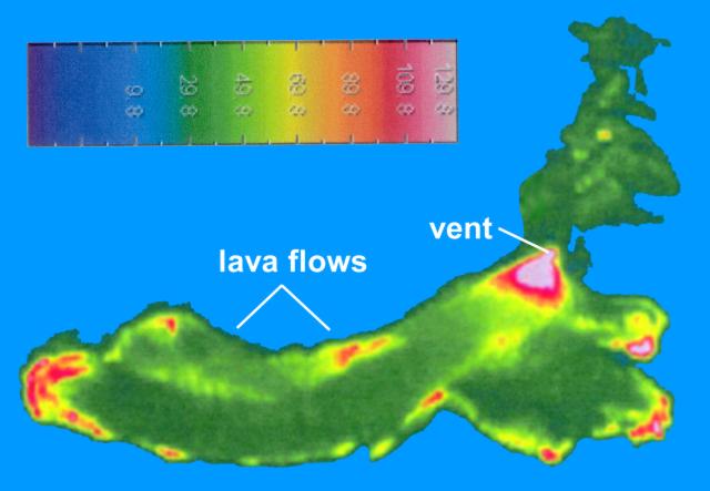 |
Figure 6. Thermal image of Pago showing recent lava flows and areas of active lava emission from the lowest vent on 28 August 2002. Low-temperature near-background values beyond the extent of the lava flows have been combined into a single shade to better define the area of lava flows. View is approximately to the SE. Courtesy of the Japanese Disaster Relief Team. |
Seismicity was stable, but without doubt exceeds its background level, although only about 40 hours of data were recorded. Approximately 20-30 small seismic events, mainly high-frequency B-type earthquakes (BL events, predominant frequency of ~3-4 Hz), were detected per hour. The S-P time of about 1.6s and polarity of first motions suggest that the seismic waves came from the direction of the lava, possibly from near the vents. Besides these BL events, there were seismic events with more complex waveforms. They might be a succession of BL events or caused by rockfalls at the edge of the lava flows. No notable swarm-type activity occurred during the observation period.
Geological Summary. The active Pago cone has grown within the Witori caldera (5.5 x 7.5 km) on the northern coast of central New Britain contains the active Pago cone. The gently sloping outer caldera flanks consist primarily of dacitic pyroclastic-flow and airfall deposits produced during a series of five major explosive eruptions from about 5,600 to 1,200 years ago, many of which may have been associated with caldera formation. Pago cone may have formed less than 350 years ago; it has grown to a height above the caldera rim, and a series of ten dacitic lava flows from it covers much of the caldera floor. The youngest of these was erupted during 2002-2003 from vents extending from the summit nearly to the NW caldera wall. The Buru caldera cuts the SW flank.
Information Contacts: Ima Itikarai, Rabaul Volcano Observatory (RVO), PO Box 386, Rabaul, E.N.B.P., Papua New Guinea; Japanese Disaster Relief Team: Kohichi Uhira, Volcanological Division, Seismological and Volcanological Department, Japan Meteorological Agency, 1-3-4 Ote-machi, Chiyoda-ku, Tokyo 100-8122, Japan; Akimitsu Takagi, Meteorological Research Institute of Japan Meteorological Agency, 1-1 Nagamine, Tsukuba, Ibaraki 305-0052, Japan; Mitsuhiro Yoshimoto, Volcano Research Center (VRC), Earthquake Research Institute (ERI), University of Tokyo, 1130032 111, Yayoi, Bunkyoku, Tokyo (URL: http://www.eri.u-tokyo.ac.jp/VRC/index_E.html); United Nations Office for the Coordination of Humanitarian Affairs (OCHA), United Nations, New York, NY 10017 USA (URL: https://reliefweb.int/); C. Dan Miller, Volcano Disaster Assistance Program, US Geological Survey, Cascades Volcano Observatory, 1300 Southeast Cardinal Court, Building 10, Suite 100, Vancouver, Washington 98683, USA (URL: http://volcanoes.usgs.gov/); David Innes, Air Niugini, PO Box 7186, Boroko, Port Moresby, National Capital District, Papua New Guinea (URL: http://www.airniugini.com.pg/).