Report on Ol Doinyo Lengai (Tanzania) — October 2002

Bulletin of the Global Volcanism Network, vol. 27, no. 10 (October 2002)
Managing Editor: Richard Wunderman.
Ol Doinyo Lengai (Tanzania) Lava exits crater at 3 points during January 2001-September 2002
Please cite this report as:
Global Volcanism Program, 2002. Report on Ol Doinyo Lengai (Tanzania) (Wunderman, R., ed.). Bulletin of the Global Volcanism Network, 27:10. Smithsonian Institution. https://doi.org/10.5479/si.GVP.BGVN200210-222120
Ol Doinyo Lengai
Tanzania
2.764°S, 35.914°E; summit elev. 2962 m
All times are local (unless otherwise noted)
In 2001-2002 the crater at Ol Doinyo Lengai has become filled with lava. The thin lava flows (nearly devoid of silica and extremely low viscosity) have begun to regularly spill over three points on the crater rim, descending hundreds of meters downslope. The crater, whose high ground was once considered suitable for camping, is no longer free from sudden inundation by lava. Activity through December 2000 was reported in BGVN 25:12.
This report chronicles many visits to the volcano between January 2001 and September 2002. Fred Belton compiled reports of multiple field parties during July 2001 and May-September 2002. Other visitors are noted in the text. Jörg Keller and Aoife McGrath contributed some observations, photos, a reference, and lab data on whole-rock chemistry.
Observations during January 2001. Paul Hloben contributed the following report. "We visited Lengai 15-17 January 2001. The place was very wet, and most of the soda coating the crater floor and cones had washed away or was in solution within the crater floor and cones. The entire crater was sandy brown and muddy (except recent lava flows, which were brown or gray and rock-hard). Older cones were just soil-brown in color, like gigantic termite mounds. [In contrast, in dry conditions, older lavas generally look white in color.] At that time only two cones were active . . . one nearest the camp site located at the path leading down the volcano."
"The [T51] cone was too high for lava flows (to escape) or for viewing what was happening inside, but we heard continuous blows every 10-20 seconds. Further on (towards the crater's center) there resided twin partially collapsed cones [newly developed features between T49 and T48, figure 71]. They harbored two active ponds (the lava level was ~1.5 m below the collapsed crust at the adjacent point of access and overview). The ponds were interconnected, with lava and gas surges occurring approximately every 20-30 seconds independently in each pond. The smaller pond (on the N) was ~1-2 m in diameter. The larger pond was about 4-5 m in diameter, but not easy to see due to heat blows that forced us to retreat; we could observe it best during the night as it was glowing."
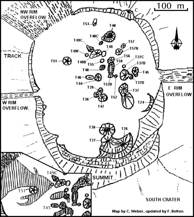 |
Figure 71. A sketch map of the crater at Ol Doinyo Lengai reflecting conditions seen up to 9 August 2002. In the rapidly changing landscape of the crater, some of the features may have been short-lived; some labeled features may not have existed at the same times. The lava ponds seen by Hloben in January 2001 are not shown, although some of their locations may coincide with later features. The inset shows lava flows active during 4-9 August 2002 (areas with a vertical striped pattern in the crater's W and central sectors). Chris Weber provided the base map; Fred Belton compiled field observations by multiple workers and made revisions on this base map. |
Comparison of field maps indicates that the larger of the two adjacent ponds stood in an area later identified as T55 (figure 71). Apparently fresh flows had recently cooled and stopped. They crossed the outflow on the NW crater rim and descended hundreds of meters down the flanks.
Observations during June 2001. Bob Carson and a group of 18 from Whitman College used the guide services of Burra Ami Gadiye to access the summit on 28 June. Carson's report follows. "We climbed on 28 June 2001 and spent from about 0800 to 1245 in the active southern crater. The crater floor was covered with about twenty steep-sided spatter cones and countless pahoehoe flows (some of the longer flows are aa-like near their toes). Radial cracks on the young surface of the crater floor penetrate the older rocks of the crater rim.
"Spatter cone T40B had been active on 27 June, sending ~10-cm-thick pahoehoe flows ~10 m from the vent; access to moisture was turning the edges of the still-warm black natrocarbonatite flows white. Later a slightly explosive eruption spewed tiny glassy spheres of tephra (1-2 mm in diameter) onto the surface of the 27 June pahoehoe flows. Spatter cone T40B sounded like a steam engine for the entire time we were near the volcano's summit. From about 1130 to 1200 on 28 June this cone erupted spatter, throwing blobs of tar-looking lava about 2 m into the air; the blobs landed on the side of the spatter cone making lava stalactites and short pahoehoe flows so that the cone looked like a giant sand castle."
Observations during July 2001. A visit by Fred Belton, Roberto Carniel, Marco Fulle, Andrew Locock, and four others during 23-30 July 2001 revealed that most of the previous year's morphologic changes occurred in the NW third of the crater. For example, T51 was 12 m tall, twice the previous year's height. T51B represented a new spatter cone just SE of T51, that contained a low rim overhanging a pit crater. Another new cone (T53) stood ~40 m NW of T40, but was inactive. Comprising a ~4 m tall rounded cone, T53 contained a hooded cave feeding a solidified open lava lake and lava channels that had flowed N. T40 had grown several meters toward the W. T40C, also new, was a white-to-gray 5-m-tall cone just SW of T40. T49B was white with a rounded summit, standing ~6 m tall. T49C was a broad cone of about the same height; it was first noted by C. Weber in October 2000. The new feature T49D was slightly lower than T49B and had vertical sides ringed with shallow grooves. T49E, probably the newest vent, formed an oval, 15 x 6 m low-rimmed crater just below the N flank of T49C.
On 23 July, T49E contained a frothy lava lake that drained N through a lava channel and frequently overflowed its E rim. By 0630 on 24 July the lava lake's surface had completely crusted over. During the day T49E inflated as lava entered and pushed up its solid surface. Early on 25 July the lake's solid surface had been lifted nearly 1 m above its position of the previous evening. It made continuous cracking and popping noises, and small rocks fell from its rim as it became increasingly engorged with lava. Cracks abruptly opened in its NW side and released copious flows of fluid lava. The filling/draining cycle was repeated twice more that day and several times on 26 July. The most interesting event occurred at 1710 on 25 July when a 3 m section of T49E's side collapsed, releasing a sudden flood of fluid lava that swept large blocks up to 9 m from their original positions (figure 72).
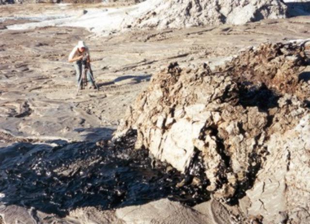 |
Figure 72. On 25 July 2001 Lengai's ~ 2-m tall, spatter cone T49E underwent a flank collapse over a ~ 3-m-wide sector. This NE-looking photo captured the scene at a late stage of the failure. Lava can be seen escaping the cone through fractures in its disintegrating wall. The entire wall collapsed outward immediately after the photo was made. The volume of material involved in the collapse (both cooled rock wall and molten lava that swept away T49E's side) was on the order of 15-25 m3. Fred Belton, who took this picture, was standing on T49C. Standing on the crater floor just beyond T49E is Roby Carniel, who ran to safety as the failure took place. Courtesy of F. Belton. |
During 27-28 July 2001 an eruption occurred that far exceeded the volume and duration of typical lava eruptions. Estimates of lava output were 5 m3/s during the greatest outflow and no less than 1 m3/s at anytime during the first 30 hours of the eruption. At 0630 on 27 July, pencil-wide streams of light gray, comparitively transparent lava flowed from T49E. T49E's lava output increased at 1113, and T49C erupted from its summit vent. At 1430 lava from those vents reached the NW crater rim overflow. Then, T49C ceased erupting, while T49D began to emit spatter from a small hole in its N side and T49B began to overflow from its summit vent. T49B developed a large dome fountain and T49D began ejecting a narrow fan of spatter at a 30° angle.
At 1510 the previously solid surface of T49E abruptly released fountains 1-2 m high, and T49C began erupting clots of spatter every 10 seconds. Thus, four vents were erupting simultaneously. Highly fluid lava flowed in meter-wide channels toward the NW, E, and S. Lava crossed the NW crater rim overflow and cascaded hundreds of meters down the NW flank of Lengai. Lava did not cross the E rim of Lengai because it flowed into a fissure in the crater floor ~25 m NW of the E rim overflow, at a rate of ~1 m3/s. About 1 hour later a vent opened on the E flank of Lengai ~12 m below the rim overflow area and released torrents of lava that flowed far down the flank and started brush fires. Destruction of a seismic station (established 4 m E of the fissure by Joshua Jones, Univ. of Washington) was narrowly averted thanks to the fissure's absorption of the lava flow and Carniel and Locock moving the equipment to a more secure location on the crater rim.
After sunset, spectacular orange fountains played steadily from T49B and T49D. Jets of incandescent gas appeared as flames 1-2 m high above the vent of T49C. By 0600 on 28 July the lava fountain from T49B was diminished but T49D continued to feed a large lava channel toward the E. Width of the channel exceeded 1 m, and depth of the fluid lava within it varied in the range 0.5-1 m. During all of 28 July lava flowed hundreds of meters down a gully on Lengai's E flank after emerging from the channel and the crater-floor fissure, both of which had been enlarged by thermal erosion. During the afternoon, the vigor of T49D's activity gradually diminished and its lava became increasingly frothy. Early on 29 July the eruption ceased and there was no further activity before observers left at 0715 on 30 July. J. Jones revisited the crater on 31 July and 6 August 2001 but saw no activity or fresh lava flows.
Observations during February-September 2002. During 3-7 February 2002, several members of the Societe de Volcanologie Geneve observed lava flows and strong fountains from the T49 complex and reported a new overflow of lava on the W crater rim (Bessard, 2002).
Aoife McGrath climbed the volcano on 26 May 2002 and reported continual small-scale eruptions at T49B. A new spatter cone had formed ~30 m SW of T49B and, according to mountain guide Burra Ami Gadiye, was about 4 months old.
During 18-22 June 2002, Christoph Weber, Jurgis Klaudius, and a film team observed the crater (figures 73 and 74). Fresh lava had flowed 120 m W from T49B and several recent 20-80 m flows originated from T46. Fresh lava was also seen on T37B, and fresh lapilli covered T48, a feature that was audibly active at depth. A new vent, designated T54, was visible between T46 and the W-rim overflow. It was an open solidified lava pond with a 40 m overflow to the W, which covered flows that had passed over the W rim in February 2002. Since August 2001, the diameter of the T49 complex had greatly increased, and there were more and hotter (>125°C) fumaroles in the crater. During this visit, spatter cones T49D, T51B, and T52C were no longer visible.
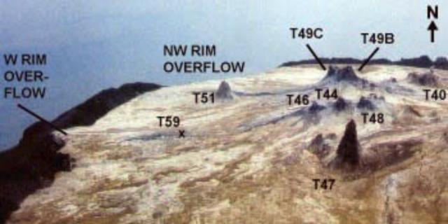 |
Figure 73. N-looking view labeling key features in the central-western crater of Ol Doinyo Lengai, as photographed on an 18-22 June 2002 crater visit. Courtesy of Chris Weber and Jurgis Klaudius. |
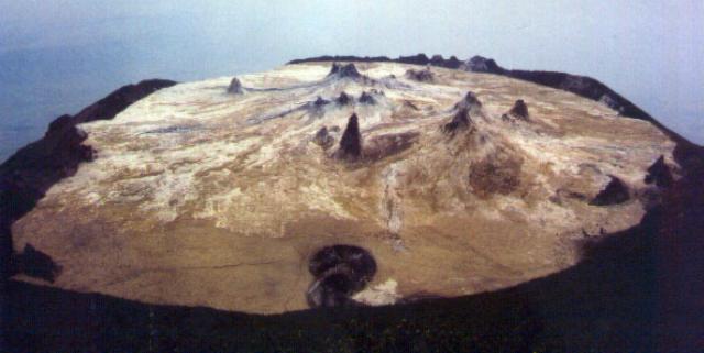 |
Figure 74. View of Ol Doinyo Lengai's entire crater as seen from the summit region (looking N) during 18-22 June 2002. Courtesy of Chris Weber and Jurgis Klaudius. |
During a five-hour period on 18 June lava spattered up to 3 m above the top of T49B (figure 75) and produced a 50-m lava flow to the NE. On 19 June spattering from T49B occurred several times until 1615, after which no further activity was seen through 22 June. On 22 June the team witnessed a ~10 m3 section of the crater wall in an area below the summit collapse into the crater. On each day there were 2-3 discrete tremors of about 1-cm amplitude, accompanied by gunshot sounds. They were distinctly different events from the continuous tremors caused by subsurface lava movement.
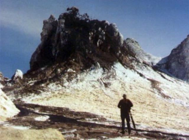 |
Figure 75. A lone photographer with a tripod photographs Ol Doinyo Lengai's vent T49B as it emits spatter in June 2002. The zone of airborne spatter is not visible on the photograph. A fresh lava flows passes close to the photograher. Courtesy of Christoph Weber. |
During the first half of July 2002 Jörg Keller was working near Lengai. He noted that until his departure on 14 July, a number of visitors returning from the summit reported either no activity or slight spattering from two cones.
During 4-9 August 2002, Fred Belton, Sven Dahlgren, Jeff Brown, and seven others observed four new spatter cones that had formed between 22 June and 4 August. One of these new cones was T55. Inactive when visited, T55 formed a white cone under 2 m tall containing a wide crater. T56, black and active, was ~7 m tall including a distinctive thin spire rising ~2 m above the summit. T57, ~4 m tall, was partly black but inactive. T57B stood ~7 m tall and was covered by fresh black lava. T54, documented by Weber on 21 June, had disappeared. Older cones such as T37B, T49B, and T49C had grown significantly since 2001 and towered above the N half of the crater rim.
Throughout the visit, T57B ejected clots of lava, expelled loud gas puffs, and produced thick clinkery aa flows. T56 spattered intermittently, T48 erupted pahoehoe lava from vents near its NW base, and T44 and T46 also produced spatter and a few short flows.
At around noon on 4 August a new vent, T49F, abruptly opened in rough, steaming ground near the W base of T49B. The eruption began with noisy ejection of spherical lapilli to a height of ~7 m and fluid lava to a height of 1 m. Throughout the day, the vent erupted at intervals of 1-2 hours, ejecting clouds of lapilli and forming aa lava flows that moved slowly W and NW to the crater rim area. Around 0200 on 5 August T49F eruptions dramatically increased in height and volume. Fountains played to at least 15 m and produced a flood of fluid pahoehoe that flowed W with great speed, destroying a supply camp. Similar eruptions continued for the next 28 hours, at first about two hours apart with gradually lengthening periods of repose between eruptions.
A typical T49F eruption consisted of lava first flowing or spattering from the low, open vent, then the abrupt onset of violent fountains that played for 2-4 minutes to a height of 10-15 m at a ~60° angle toward the W, and finally a decrease in fountain height and the draining of lava back into the vent. The final draining accompanied loud noises that to J. Brown sounded like "sheet metal being bent." By the afternoon of 5 August the site of the supply camp was under at least 1 m of thick pahoehoe slabs. The area just W of the vent was more than ankle deep in 2-8-mm-diameter spherical lapilli. Three vigorous fountaining episodes at T49F the night of 5 August started brush fires along the W crater rim. After dawn on 6 August, T49F's activity gradually waned, completely stopping by evening.
On 7 and 8 August T49F was completely inactive, thin pahoehoe lava flowed from T48, and T57B produced meter-thick clinkery aa flows. In the central crater there was an exceptionally strong smell of sulfur that at times made breathing uncomfortable, continuous low-pitched audible vibrations, and frequent hard bumps and tremors underfoot, especially near T57B and T56.
At about 2300 on 8 August a fissure ~12 m in length opened between T52B and T56 and began erupting a curtain of fire 6-8 m high with nearly continuous violent explosions. After midnight observers began to see an elongated spatter cone containing an extremely vigorous lava lake, whose surface rose ~0.3 m/hour. The new cone (T58) gradually merged with the flanks of T52B and T56. By 0830, T58 was over 2 m tall and its lava lake measured ~5 x 9 m. Lava bubbles over 2 m in diameter burst every 1-3 seconds and the activity showed no sign of abating when observers left at 0830 on 9 August. A photo from 17 August by Jean Bahr documented that T58 had grown to ~10 m in height and had a wide circular summit vent.
On 26 September 2002, Celia Nyamweru and twenty St. Lawrence University students visited the crater during 0630-0830. Lava spattered from T55 at 10-20 second intervals. Highly fluid pahoehoe lava emerged from the lower N slope of T49 and moved across other recent flows, probably from the previous night, which had passed between T40 and T40C and partially surrounded T53. Lava had accumulated against the N wall of the crater rim (then only 5 m high) and was heard flowing into a crack in the wall. The visitors could not see where the lava was going, but the next morning (27 September) as they were leaving the area by road a grass fire (started by lava?) was visible on the cone's upper NW slope. A local Maasai woman said that she had heard a loud noise from the volcano in the night. However, no activity was visible from the lowland N of Lengai.
Nyamweru's team observed one big crack, with steam, sulfur fumes, and black and yellow staining, running NW across the NW crater floor near T53. Other cracks on the NE floor were up to 30 or 40 cm wide and ran into cracks in the crater wall that were not steaming. The cones T26, T27, and T30 were still visible at the base of the S crater wall, surrounded by younger but deeply weathered lavas. The rim of T30 was less than 3 m above the lava surface, but its circular pit was still very well defined. In the NE segment of the crater floor a big blocky flow, brown and crumbly, bordered the NE wall for a considerable distance. It may have originated from T57 or T57B. Many cones from all parts of the crater were gently emitting steam, including T51, T45, T37, T30, and T47. The SE crater floor was very heavily weathered, with no sign of any fresh lava. There were a couple of patches of ground (each a shallow depression about 50 m2) that seemed to be the sites of former standing water. The depressions were floored with very fine pale brown clay/mud, which showed some fine layers and some areas with polygonal cracks. This seemed to be 'sediment' washed off the weathered lava by rain.
The most striking features of the topography were the extent to which the central crater floor has been built up. Except for the big wall to the S that rises to the summit, the topographic expression of the outer crater wall has diminished considerably (table 3). This impression was reinforced on 27 September when at a point about 10 km E of Lengai, they could look back and see the tops of several spatter cones showing above the eastern crater wall.
Table 3. Lava escaped Ol Doinyo Lengai's summit crater at three spots on the rim descending over the NW, E, and W sides. Visitors to the summit recorded these widths at each of the crater outlets. Courtesy of C. Nyamweru and F. Belton.
| Date | Location | Overflow width (m) |
| 30 Jul 2001 | NW rim | 106 |
| 30 Jul 2001 | E rim | 33 |
| 26 Sep 2002 | NW rim | 135 |
| 26 Sep 2002 | E rim | 39 |
| 26 Sep 2002 | W rim | 12 |
Jörg Keller provided photographs showing the evolution of the crater from 1988 through the present, emphasizing the progressive upward growth of the crater floor (figure 76). The sequence shows how the volcano has reached a critical stage where extremely fluid lavas can pour down the flanks.
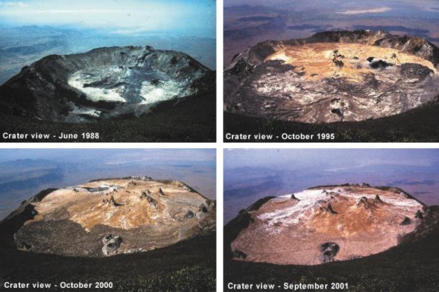 |
Figure 76. A suite of photographs showing Lengai's crater evolution, 1988-2002. The photographs were taken from the same position with respect to the summit (looking toward the N). Courtesy Jörg Keller and Jurgis Klaudius. |
Whole-rock chemistry. Lengai's lavas have been analyzed by several techniques. High-precision XRF (x-ray fluorescence) analyses (table 4) were cross-checked and confirmed with ICP and ICP-MS (inductively coupled plasma and inductively coupled plasma mass spectrometer) instruments. The geochemistry of these lavas are of interest because of their unusual low-silica natrocarbonatite compositions.
Table 4. Natrocarbonatite compositions at Ol Doinyo Lengai for lavas erupted in 1988, 1995, and 2000. Analyses were by XRF. * From Keller and Krafft, 1990. Courtesy of Jürg Keller and Aoife McGrath.
| Sample | OL 102* | OL 122 | OL 148 |
| Eruption Date | 1988 | 1995 | 2000 |
| SiO2 | 0.16 | 0.53 | 0.24 |
| TiO2 | 0.02 | 0.02 | 0.02 |
| Al2O3 | b.d. | 0.13 | 0.01 |
| Fe2O3t | 0.28 | 0.91 | 0.37 |
| MnO | 0.38 | 0.39 | 0.46 |
| MgO | 0.38 | 0.39 | 0.46 |
| CaO | 14.02 | 16.25 | 14.61 |
| SrO | 1.42 | 1.4 | 1.42 |
| BaO | 1.6 | 1.25 | 1.71 |
| Na2O | 32.22 | 32.22 | 32.64 |
| K2O | 8.38 | 7.52 | 8.41 |
| P2O5 | 0.85 | 0.93 | 0.72 |
| CO2 | 31.55 | 32.7 | 30.9 |
| Cl | 3.4 | 3.16 | 4.53 |
| SO3 | 3.72 | 2.23 | 2.35 |
| F | 2.5 | 2.57 | 3.47 |
| H2O | 0.56 | 0.01 | 0.01 |
| - O = F, Cl | -1.82 | -1.91 | -2.48 |
| Total | 99.62 | 100.7 | 99.85 |
Safety warnings. Deep radial cracks in the crater floor present a serious risk to visitors walking in the crater of Ol Doinyo Lengai, especially at night. Some of the cracks may be hidden by thin lava flows. Protective eyeglasses should be worn near any type of activity. In 2001 an observer without glasses was hit in one eye by spatter and escaped serious injury because his eye was closed at the moment of impact. He sustained second-degree burns on both eyelids.
Camping inside the active N crater has become much more dangerous due to increased crater floor steepness that allows lava from the central spatter cones to reach the crater rim very quickly. Around 0200 on 5 August 2002, fluid pahoehoe lava from the T49F vent destroyed a supply camp and injured Paul Mongi, a Tanzanian guide. One of Belton's websites gives credit to guides like Mongi, who have aided numerous visitors. (Mongi has recovered from second-degree burns on one foot, sustained when lava ignited his sleeping bag.) Lava invaded the camp in spite of a small ridge separating the camp from the crater floor. No location in the active crater is safe from lava flows. Sudden outbreaks of explosive lava fountains are also a serious risk. On 8 August 2002 two observers walked across the site of the T58 fissure eruption little more than an hour before the activity began. Contributors recommended that camps be set up in the inactive S crater, a 15 minute walk away.
References. Keller, J., and Krafft, M., 1990, Effusive natrocarbonatite activity of Oldoinyo Lengai, June 1988, Bulletin of Volcanology, v. 52, no. 8, p. 629-645.
Bessard, Yves, 2002, Ol Doinyo Lengai: Société de Volcanologie-Geneve (SVG), no. 22 (April 2002), p. 2-10 (URL: http://www.volcans.ch/).
Geological Summary. The symmetrical Ol Doinyo Lengai is the only volcano known to have erupted carbonatite tephras and lavas in historical time. The prominent stratovolcano, known to the Maasai as "The Mountain of God," rises abruptly above the broad plain south of Lake Natron in the Gregory Rift Valley. The cone-building stage ended about 15,000 years ago and was followed by periodic ejection of natrocarbonatitic and nephelinite tephra during the Holocene. Historical eruptions have consisted of smaller tephra ejections and emission of numerous natrocarbonatitic lava flows on the floor of the summit crater and occasionally down the upper flanks. The depth and morphology of the northern crater have changed dramatically during the course of historical eruptions, ranging from steep crater walls about 200 m deep in the mid-20th century to shallow platforms mostly filling the crater. Long-term lava effusion in the summit crater beginning in 1983 had by the turn of the century mostly filled the northern crater; by late 1998 lava had begun overflowing the crater rim.
Information Contacts: Fred Belton, Developmental Studies, Middle Tennessee State University, Murfreesboro, TN 37132, USA (URL: http://oldoinyolengai.pbworks.com/); Paul Hloben, P.O. Box 71860, Bryanston 2021, South Africa; Bob Carson, Department of Geology, Whitman College, Walla Walla, WA 99362, USA; Burra Ami Gadiye, c/o Sengo Safari Tours, P.O. Box 207, Arusha, Tanzania, Africa; Roberto Carniel, Dip. Georisorse e Territorio, Universita' di Udine Via Cotonificio, 114-33100 Udine, Italy (URL: http://www.swisseduc.ch/stromboli/); Sven Dahlgren, Fylkeshuset, Svend Foynsgt 9, 3126 Tonsberg, Norway; Marco Fulle, Osservatorio Astronomico, Via Tiepolo 11, I-34131 Trieste, Italy (URL: http://www.swisseduc.ch/stromboli/); Jörg Keller, Universitaet Freiburg, Albertstr. 23b, D-79104 Freiburg, Germany; Aoife McGrath, Senior Exploration Geologist, Geita Gold Mine, P.O. Box 532, Geita, Mwanza, Tanzania; Jurgis Klaudius, Institut für Mineralogie, Petrologie und Geochemie, Albertstr. 23 B, 79104 Freiburg, Germany; Andrew Locock, Dept. of Civil Engineering and Geological Sciences, University of Notre Dame, Notre Dame, IN 46556, USA; Celia Nyamweru, Dept. of Anthropology, St. Lawerence University, Canton, NY 13617, USA (URL: http://blogs.stlawu.edu/lengai/); Joshua Jones, Department of Earth & Space Sciences, Box 351310, Seattle, WA 98195-1310, USA; Jean M. Bahr, University of Wisconsin-Madison, Dept. of Geology & Geophysics, 411 Weeks Hall, 1215 W Dayton St. Madison, WI 53706, USA (URL: http://geoscience.wisc.edu/geoscience/people/faculty/jean-bahr/); Christoph Weber, Volcano Expeditions International, Muehlweg 11, 74199 Untergruppenbach, Germany (URL: http://www.Vulkanexpeditionen.de/).