Report on Colima (Mexico) — November 2002

Bulletin of the Global Volcanism Network, vol. 27, no. 11 (November 2002)
Managing Editor: Richard Wunderman.
Colima (Mexico) New lava flows emitted during February through at least December 2002
Please cite this report as:
Global Volcanism Program, 2002. Report on Colima (Mexico) (Wunderman, R., ed.). Bulletin of the Global Volcanism Network, 27:11. Smithsonian Institution. https://doi.org/10.5479/si.GVP.BGVN200211-341040
Colima
Mexico
19.514°N, 103.62°W; summit elev. 3850 m
All times are local (unless otherwise noted)
New lava flows began at Colima on 14 February 2002 (BGVN 27:05). The lavas traveled from the central crater proceeding down the SW flank until May (areas 1 and 2 on figure 62). During June-December 2002, three small lava flows developed (areas 3-5 on figure 62). The latter three flows were first noted on 21 June; the mean rate of lava emission was very low, ~0.1 m3/s. Flow 3 stopped on 12 July; flows 4 and 5 continued their activity into at least mid-December. Pulses of higher lava emission occurred during the eruption of flows 4 and 5 (19 July and 10 November 2002, respectively).
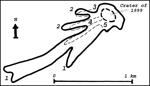 |
Figure 62. Sketch of the February-December 2002 lava flows (1-5) on Colima's SW flanks. Three new lava flows (3-5) are shown by dashed lines. Courtesy of Observatorio Vulcanológico de la Universidad de Colima. |
Seismicity varied significantly during January-December 2002 (figure 63). June-December pulses in emission and lava-flow velocity were associated with numerous rockfalls and elevated seismicity. Periods of elevated seismicity and lava emission took place on 14 February (pulse I), 21 June (II), 19 July (III), and 10 November (IV).
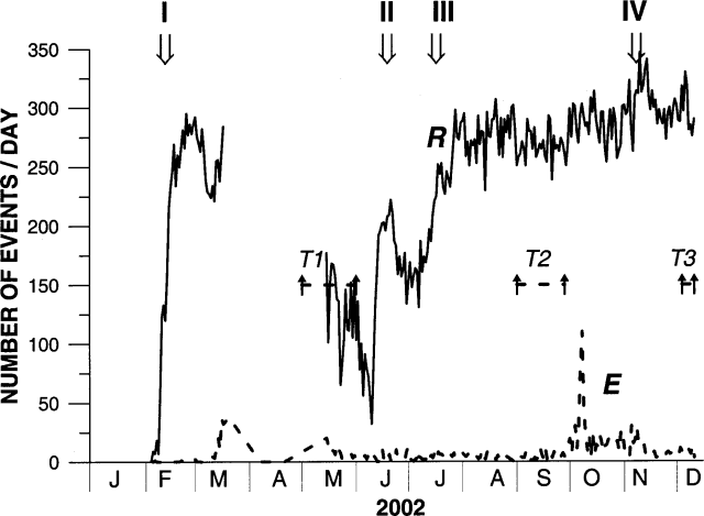 |
Figure 63. Colima's inferred daily number of rockfalls and pyroclastic flows (upper curves, labeled R) and small explosions (lower curve, dashed and labeled E). Both these estimates were based on seismic data received 1.7 km from the crater (at station Soma). Strong seismic noise occurred during 18 March to 14 May, preventing accurate rockfall estimation. Arrows with Roman numerals (I-IV) identify pulses in seismicity and lava emission. Intervals labeled T1-T3 indicate periods when tremor continued 12 to 24 hours per day. Courtesy of Observatorio Vulcanológico de la Universidad de Colima. |
With the appearance of lava flows on 21 June, the number of rockfalls sharply increased, and then stabilized at 250-300 per day after the July pulse (lava pulse III). The June-December stage of the eruption was accompanied by numerous small gas explosions and periods of low-amplitude volcanic tremor. Tremor episodes lasting 12-24 hours/day are marked as T2 and T3 on figure 63. These tremor episodes were not associated with observable changes in volcanic activity.
Geological Summary. The Colima complex is the most prominent volcanic center of the western Mexican Volcanic Belt. It consists of two southward-younging volcanoes, Nevado de Colima (the high point of the complex) on the north and the historically active Volcán de Colima at the south. A group of late-Pleistocene cinder cones is located on the floor of the Colima graben west and east of the complex. Volcán de Colima (also known as Volcán Fuego) is a youthful stratovolcano constructed within a 5-km-wide scarp, breached to the south, that has been the source of large debris avalanches. Major slope failures have occurred repeatedly from both the Nevado and Colima cones, producing thick debris-avalanche deposits on three sides of the complex. Frequent recorded eruptions date back to the 16th century. Occasional major explosive eruptions have destroyed the summit (most recently in 1913) and left a deep, steep-sided crater that was slowly refilled and then overtopped by lava dome growth.
Information Contacts: Observatorio Vulcanológico de la Universidad de Colima, Colima, Col., 28045, México.