Report on Reventador (Ecuador) — November 2002

Bulletin of the Global Volcanism Network, vol. 27, no. 11 (November 2002)
Managing Editor: Richard Wunderman.
Reventador (Ecuador) Strong, sudden 3 November eruption; 8-km-long pyroclastic flow
Please cite this report as:
Global Volcanism Program, 2002. Report on Reventador (Ecuador) (Wunderman, R., ed.). Bulletin of the Global Volcanism Network, 27:11. Smithsonian Institution. https://doi.org/10.5479/si.GVP.BGVN200211-352010
Reventador
Ecuador
0.077°S, 77.656°W; summit elev. 3562 m
All times are local (unless otherwise noted)
After a 26 year repose without signs of unusual activity, Reventador burst unexpectedly into a VEI 4 eruption on 3 November 2002. Seismometers, including some located 15 and 24 km away, only began to detect anomalous seismicity 4 hours prior to the eruption's visual confirmation. A preliminary evaluation implies that this was one of Ecuador's most powerful eruptions of the past 100 years.
A vertical aerial photograph of Reventador's edifice taken in 1983 (figure 2) has been annotated by Minard (Pete) Hall to show the age and distribution of lava flows. During the 2002 eruption onlookers took a series of photos; a side view captured at an early stage appears in figure 3.
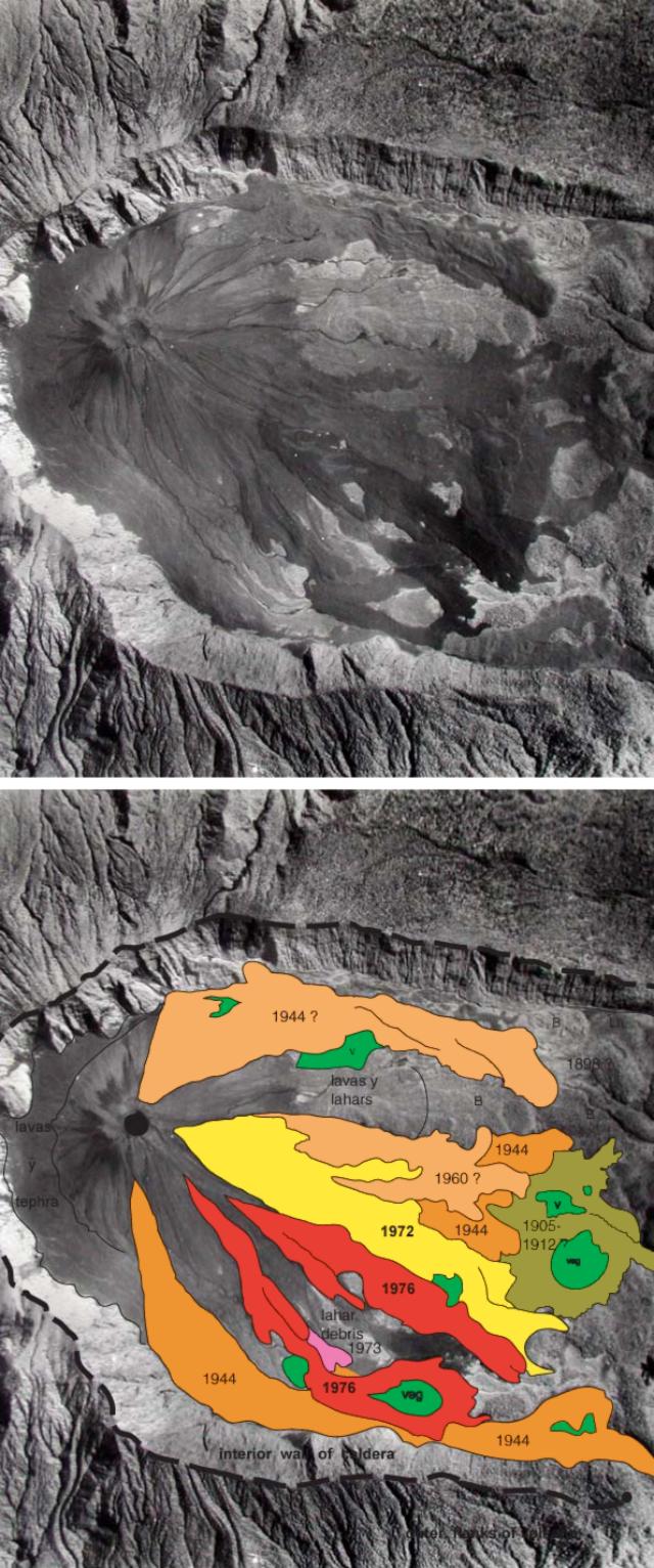 |
Figure 2. Aerial photo of Reventador caldera taken in 1983. Top of photo lies to the N; the walls of the E-breached caldera are 3-4 km apart. The bottom image is the same photo with map overlays of lava flows and key features. Although cut off in this cropped figure, the caldera's W wall is intact. Courtesy of Instituto Geografico Militar de Quito and Instituto Geofisico, Escuela Politecnica Nacional, Quito, Ecuador (IG). |
The following tentative chronology of the eruption is based upon IG seismic and NOAA data, as well as eyewitness accounts and photos. The chronology of the events on 3 November is detailed in table 1. At press time editors were unable to learn the latest details regarding timing but these will appear in a subsequent report.
Table 1. Chronology of events that took place at Reventador on 3 November 2002. Courtesy IG and NOAA.
| Time | Activity |
| 0300 | Beginning of seismic swarm of 100 events, most of a hybrid tendency characterized by frequencies of 1.8 to 4.2 Hz and seismic tremor of low frequency (0.7-1.0 Hz). Workers at base camp located 8 km from cone were awakened by earthquakes. |
| 0530 | At daylight workers reported a steam column 2-3 km high above cone. |
| 0715 | Pilots from TAME Airline reported ash plume in the direction of Reventador. |
| 0715-0745 | NOAA GOES images first show eruption cloud. |
| 0745 | Witnesses reported increased intensity of eruptive column, now reaching ~6 km above the cone and drifting to the SW. |
| 0803 | Photos show that eruption column had reached 7,300 m above cone and suggest small pyroclastic flows. Successive explosions and a constant roar were heard at 8 km distance, but not at closest town at 15 km distance. |
| 0815 | GOES images show eruption cloud beginning to travel to SW. |
| 0912 | Main eruption begins. Column soon rises to 16-17 km above cone. |
| 1415 and 1615-1715 | Other important pulses of the eruption. |
| 1300 approx. | Ash cloud reaches InterAndean Valley and Quito, ~100 km from the volcano, causing almost total obscurity by late afternoon. It left a layer up to 3-5 mm thick of fine gray ash everywhere. Some closer towns received up to 3 cm of ash. Most residents of the region complained about the strong odor of both SO2 and H2S. |
| 2005 | Another intensification of eruptive activity (which continued until 0100 on 4 November). |
On 6 October 2002 a M 4.1 seismic event occurred beneath the volcano, accompanied by nine smaller VT events; the tentative epicenter was slightly SW and W of the cone. Around 20 October a local guide with tourists reached the top of the cone and saw only normal fumarolic activity. No anomalous activity was detected by satellite monitoring during this period.
Table 1 summarizes seismic, visual, and satellite observations of the initial eruptions on 3 November that led to the main eruption's starting at 0912. In that energetic phase a column rose 16-17 km above the intracaldera cone. At least five significant pyroclastic flows (PFs) were produced. A photo sequence showed PFs descending SE along the southern caldera floor and obliquely overriding the 200-400-m-high southern caldera rim (figure 3).
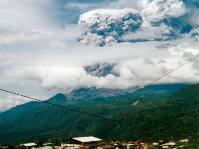 |
Figure 3. A photo showing the young intracaldera cone and main eruption column (on right) of Reventador at 0912 (local time) on 3 November 2002. The view is looking SW from the town of Reventador, 14 km to the volcano's NE. The shot captured a pyroclastic flow traveling along the S side of the caldera floor and overtopping the caldera rim; a topographic boundary 200-400 m high. Note the expansive ash cloud above the pyroclastic flow. Photo taken by R. Saca; provided courtesy IG. |
The longest PF traveled 8 km; it flowed out of the breached caldera and down steep slopes to reach the Quijos river. In doing so, it crossed important oil and gas pipelines, pushing them ~20 m downslope without inducing failure. It destroyed an oil pipeline still under construction, and carried away small bridges on the main dirt highway leading to the oilfields. The PF buried one small house and 20 head of cattle. No casualties were reported.
Two segments of the ash column took different paths. The segment of the column that rose up to 16 km high blew to the SW and WSW toward Quito and the populated InterAndean Valley, traveling at 30-45 km/hour. The ash cloud above 16 km moved E and reached southern Colombia and northwestern Brazil. J.L. LePennec (IRD) estimated that ~282 x 106 m3 of pyroclastic material was erupted.
This eruptive event largely destroyed the old summit crater in the intracaldera cone. It was left with two deep notches in its uppermost NNW and SSW sides. These notches apparently served as the source of both the PFs and lava flow number 1. An eyewitness observed rock ejection during this episode. The eruptive event that began at 0912 lasted ~45 minutes, but eyewitnesses indicated that most of the PF activity lasted only 10 minutes.
Throughout the day on 3 November seismic activity was pronounced and included seismic tremor (1-2 Hz), long-period (LP) events (1.5-1.7 Hz), a few volcano-tectonic (VT) events (2-4 Hz and 12-14 Hz), but mainly hybrid events (with initial phases at 2-8 Hz, followed by a main phase at 1-2 Hz).
On 4 November, during 1200-1300, explosions continued but with much less intensity. Ash and steam continued to rise. During the day, TOMS satellite measured up to 60,000 metric tons/day of SO2 (figure 4). In subsequent days, TOMS estimates remained around 5,000 to 20,000 metric tons/day through 21 November (figure 4).
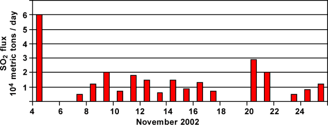 |
Figure 4. Reventador's SO2 output based upon TOMS satellite data reflecting the interval 4-26 November 2002. Courtesy of Simon Carn and Arlin Krueger. |
The next day, on 5 November, small explosions continued, but at 1300 a significant explosion may have generated PFs. Debris flows formed in the days following the PF emplacement mainly covered parts of the PF deposits and also reached the Quijos river, ~8 km from the crater.
During 6-7 November the volcano continued to emit ash, gases, and steam, but at reduced levels. Lava flow number 1 was presumed to have begun during this time, which was later confirmed by NOAA thermal images to have begun at 1900 on 7 November. The lava flow, several hundred meters wide, left the crater area and cone, and traveled SE down the caldera floor near the S caldera wall. An 8 November overflight by Jorge Anhalzer visually confirmed a 4-km-long lava flow, overriding the PF deposits and lahar plain. By 3 December it had traveled 5 km, but it was advancing at only ~1-3 m/day. Through late December observers confirmed that the lava flow continued to move.
During 8-21 November a short eruption column continued, but with increasingly more steam and gas relative to ash. No clear explosions were heard. Variable debris-flow activity occurred, depending upon the intensity of local rainfall. Sulfur gases were occassionally noted in the InterAndean Valley and in Quito.
On 21 November a second lava flow broke out on the lower SE foot of the cone at ~2,600 m elevation and descended to the ESE. By 3 December it had traveled 2 km and was accumulating against the side of the first lava flow.
From 21 November until 3 December there was no additional explosive or PF activity, the steam-rich plume rose to only 1-2 km, and the two lava flows continued moving at a rate of a few meters/day. Debris flows remained a threat to the workers repairing the pipelines and travelers along the main highway.
Setting and sketch map. Reventador stratovolcano is on the E flank of the Ecuadorian Andes in jungles of the western Amazon basin. It contains a 3-km-wide caldera with a young, unvegetated cone that rises ~1,300 m above the caldera floor. The caldera is breached to the E and frequent lahars in this region of heavy rainfall have constructed a debris plain on the E caldera floor. No population centers exist nearby; however, the principal oil and gas pipelines and an important highway cross the lower flanks of the volcano, precisely where most flows exited the caldera (figure 5).
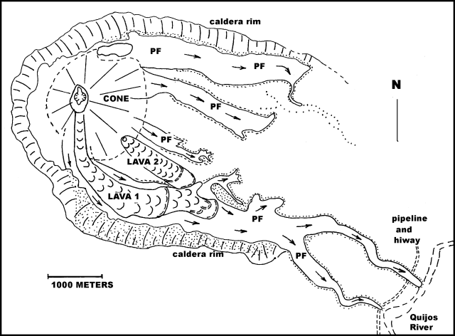 |
Figure 5. Sketch map showing deposits resulting from the November 2002 eruption of Reventador. PF signifies pyroclastic-flow deposits; stippled area shows downed trees and burned vegetation caused by PF's. The map shows the lava flow's advance as of 25 November. Note the oil and gas pipeline near the terminal ends of the PFs. This map omits the debris-flow deposits, which largely covered the PF deposits. Courtesy M. Hall. |
The young andesitic cone is within an older caldera (figures 2 and 5). The caldera's interior walls reach heights of 200-400 m, especially at its higher W end. Traces of an older somma rim lie concentrically outside the present W walls of the caldera. The caldera contains older lava flows and pyroclastic-flow and debris-flow deposits; the resulting caldera floor is higher in its W corner, slopes downward to the SE, and drains into the Quijos river.
The symmetrical composite cone of Reventador is presently at an elevation of ~3,500 m, 1,500 m above the lowest point at the SE end of the caldera. The slopes of the young cone average 34 degrees. The cone is slightly higher than the adjacent caldera rim, although a 1931 report stated that it was lower than the rim. Prior to this eruption the summit crater had a diameter of ~200 m and typically displayed mild fumarolic activity. Recent magmas are typically 56-58% SiO2 and carry olivine, two pyroxenes, and plagioclase.
Some 14 eruptions of sufficient magnitude to have been detected at appreciable distances occurred between 1541 and 1926 (Hall, 1977). The volcano was first visited in 1931, following its 1926-1929 eruption period. K.T. Goldschmid, a Shell Oil Company geologist, visited the volcano during its 1944 eruption. Eruptive activity occurred in 1960. Another cycle began in July 1972 and lasted until 1976, during which lava flows, small PFs, and debris flows were generated in four eruptive episodes; however, neither ashfalls nor strong sulfur gases were noted in the InterAndean Valley. A detailed listing of past eruptions is available from IG upon request.
Monitoring. Just months prior to the eruption, in April 2002, IG staff installed two new seismic stations (1 Hz, vertical, telemetered). With respect to the crater, the new stations sit 15 km ENE and at 24 km SW. They were operating during the November 2002 crisis (figure 6). After 3 November two similar stations were installed 7.5 km SE and 8 km E of the crater. Older stations important in monitoring the eruption include the two Cayambe stations, located ~40 km NW of Reventador, and Pino station on Guagua Pichincha, located about 100 km WSW. Most locatable earthquakes had shallow hypocenters beneath either the caldera's outer western flanks or under the young cone.
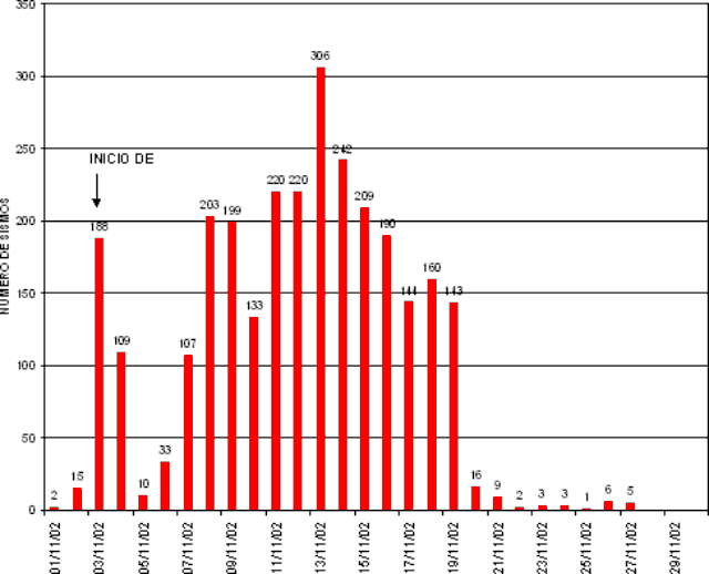 |
Figure 6. A histogram showing the daily number of all types of earthquakes registered at Reventador during November 2002. Courtesy Instituto Geofisico. |
Daily numbers of seismic events detected in November are show graphically on figure 6. Prior to the current eruption, the volcano averaged ~7 events/day. During the eruption, the average stood at ~142 events/day, chiefly hybrid earthquakes that began with higher frequencies and after a few seconds dropped to lower frequencies.
The eruption's first day was associated with more than 188 events, while the 2nd thru 5th days had only 50-100 events. By 8 November, the number of events generally remained above 200/day, dropping on 17 November to under 150/day, and dropping still further by 20 November. This abrupt decline was possibly associated with the eventual breakout of the second lava flow on 21 November.
No deformation or chemical monitoring was being carried out on the volcano prior to this eruption. TOMS SO2 monitoring as well as thermal monitoring by satellite have been extremely important, given the remoteness and inaccessibility of Reventador. Flights by an UltraLight and light planes have resulted in some photographic coverage and thermal imaging with a FLIR camera.
Effects of the 2002 eruption. Widespread ashfall to the W and SW caused visibility problems, respiratory ailments, some roof collapses, an undisclosed number of deaths and injuries to people attempting to clean their roofs of ash, crop damages, cattle illnesses, closure of Quito's airport for eight days, and power outages in some areas for up to four days. Legally enforced cleaning of all public streets and sidewalks by broom-wielding residents limited the amount of ash entering sewer systems. Lower speed limits were put in place to reduce airborne ash kicked up by passing vehicles. Ecuador's principal crude oil pipeline, although not severed, remained threatened by daily debris flows. One approach to this problem may be to bury the pipeline where it traverses the volcano's vulnerable E slopes.
References. Belloni, L.C., 1989, Slope failures on the volcano "El Reventador" in eastern Ecuador (discussions on volcanic debris), in Proceedings of the Twelfth international conference on Soil mechanics and foundation engineering—Comptes rendus du douzieme congres international de Mechanique des sols et des travaux de foundations, no. 12, v. 5, p. 2851.
Hall, M.L., 1980, El Reventador, Ecuador; un volcan activo de los Andes Septentrionales (El Reventador, Ecuador; an active volcano in the northern Andes): Politecnica 5, p. 123-136.
Hall, M.L., 1979, Volcan Reventador, Ecuador.Volcano News, v. 1, p. 1-3.
Hoyt, D.V., 1978, An explosive volcanic eruption in the Southern Hemisphere in 1928. Nature (London). 275; 5681, Pages 630-632.
Salazar, M.E., 1983, Expedicion vulcanologica el Volcan Reventador (Volcanologic expedition to Reventador Volcano): Flysch, v. 4, p. 1-4.
Geological Summary. Volcán El Reventador is the most frequently active of a chain of Ecuadorian volcanoes in the Cordillera Real, well east of the principal volcanic axis. The forested, dominantly andesitic stratovolcano has 4-km-wide avalanche scarp open to the E formed by edifice collapse. A young, unvegetated, cone rises from the amphitheater floor to a height comparable to the rim. It has been the source of numerous lava flows as well as explosive eruptions visible from Quito, about 90 km ESE. Frequent lahars in this region of heavy rainfall have left extensive deposits on the scarp slope. The largest recorded eruption took place in 2002, producing a 17-km-high eruption column, pyroclastic flows that traveled up to 8 km, and lava flows from summit and flank vents.
Information Contacts: P. Ramon, M. Hall, P. Mothes, and H. Yepes, Instituto Geofísico (IG), Escuela Politécnica Nacional, Quito (URL: http://www.igepn.edu.ec/); J.P. Eissen and Jean-Luc LePennec, French IRD (Institut de recherche pour le Développement) Representatives, Mission IRD-Whimper 442 y Corúa-Apartado Postal 17-12-857, Quito, Ecuador; Franz Böker, BGR (Bundesanstalt für Geowissenschaften und Rohstoffe), Alfred-Bentz-Haus, Stilleweg 2, D-30655 Hannover, Germany; George Stephens, Operational Significant Event Imagery (OSEI) team, World Weather Bldg., 5200 Auth Rd Rm 510 (E/SP 22), NOAA/NESDIS, Camp Springs, MD 20748USA; Arlin Krueger and Simon A. Carn, Joint Center for Earth Systems Technology (NASA/UMBC), University of Maryland-Baltimore County, 1000 Hilltop Circle, Baltimore, MD.