Report on Witori (Papua New Guinea) — December 2002
Bulletin of the Global Volcanism Network, vol. 27, no. 12 (December 2002)
Managing Editor: Richard Wunderman.
Witori (Papua New Guinea) Dacite lava flows, flattened forest, deformation, and faulting
Please cite this report as:
Global Volcanism Program, 2002. Report on Witori (Papua New Guinea) (Wunderman, R., ed.). Bulletin of the Global Volcanism Network, 27:12. Smithsonian Institution. https://doi.org/10.5479/si.GVP.BGVN200212-252080
Witori
Papua New Guinea
5.5745°S, 150.5161°E; summit elev. 724 m
All times are local (unless otherwise noted)
Additional information about Mt. Pago's recent eruption (BGVN 27:07-27:09) has been provided by members of the U.S. Geological Survey's Volcano Disaster Assistance Program (VDAP). The team donated to the GVP archives an extensive suite of digital photographs (still and video) taken during August-October 2002. The photographers included the helicopter pilot Alan Cameron (Heli Niugini), and VDAP members Andy Lockhart, Jeff Marso, and Elliot Endo.
In terms of the basic distribution of eruptive products, the August-October 2002 photos (figures 7-16) appeared similar to those shown in earlier reports (BGVN 27:07-27:09). All photos were taken from a helicopter, often during routine observation flights provided by the West New Britain Provincial Government. For scale on some of the photos, Cameron estimated that tree heights ranged from 5-30 m, with the taller trees in the low-lying areas and most of the ones in the photos at the shorter end of that range.
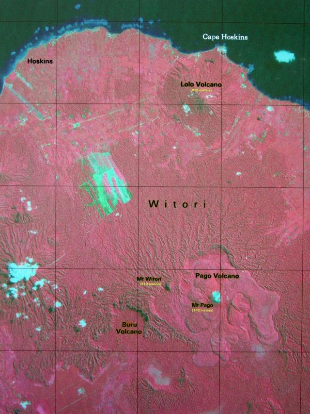 |
Figure 7. A false-color Landsat satellite image labeling some key features at Mt. Pago and its vicinity. N is upwards (parallel to the grid lines) and, for scale, Pago lies ~20 km S of the coast at Cape Hoskins. Although the settlement at Hoskins is labeled, several others also lie along the coast, including some E of Lolo volcano. Taken by LANDSAT 7 on 26 May 2002 (path 94, row 64) and provided courtesy of USGS-VDAP. |
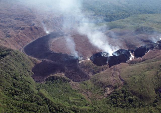 |
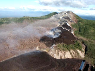
Figure 8. An overview of Pago's N sector taken on 7 October 2002 and showing middle to lower flanks and caldera. The shot was taken from the NW, sighting cross-wise to the aligned chain of recent eruptive vents. Freshly erupted lavas have thus far remained confined within the caldera. The extruded massive dacitic lavas include two lava tongues flowing towards the viewer and a larger lava flow ponded in the distance, banked up against older (1911-18) intra-caldera lavas and the caldera's topographic margins. The wide zone of discolored vegetation continues well beyond both the caldera's topographic margin and the photo's left-hand edge. This and several other features such as a zone of deformation and faulting (lower center) appear less distinct here but are highlighted on later figures. Courtesy of USGS-VDAP. |
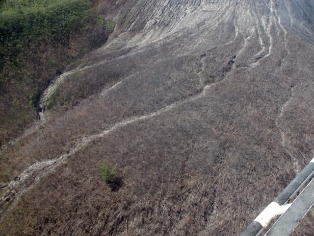 |
Figure 9. Upper NE flanks of Pago highlighting the broad zone of denuded and knocked-down vegetation there. Most of the trees have been laid flat, and there exist occasional cleared-out gullies resembling avalanche chutes, washouts, and lahar paths. Courtesy of the USGS-VDAP. |
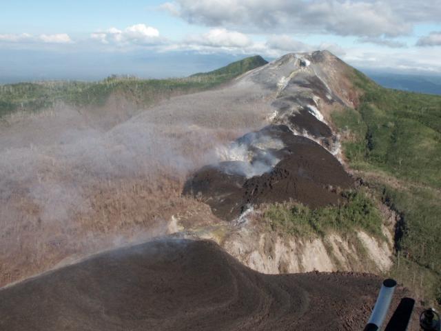 |
Figure 10. A 16 September 2002 view of Pago, as seen looking SSE towards the summit along the aligned, radial-trending chain of vents. Massive lava flows lie in the foreground. Their extrusive vent sits along the main fissure below the lowest cone, in an area of local degassing and conspicuous yellow deposits. Provided courtesy of USGS-VDAP. |
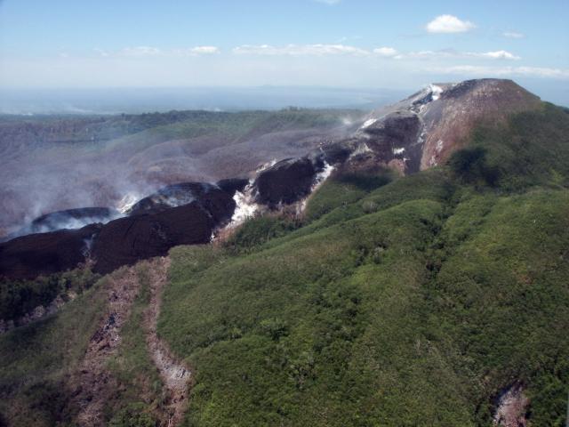 |
Figure 11. A 13 September 2002 photo of Pago's middle-to-upper flanks, including the summit crater and the higher-elevation radial-vent areas. This photo was taken from the NW; in many other photos taken during August-October 2002 white steam plumes tended to obscure the ground. Note the sub-linear swaths of denuded vegetation, particularly two swaths in the left foreground, and the broad area of discolored vegetation in the background behind the fresh lava. The swaths denote the surface traces of recent faults with significant offset, places where existing trees had fallen over. Observation flights in mid- to late September disclosed still further visible, meter-length deformations in this area. Observers inferred that these features reflected a graben formed in the upper portion of a cryptodome. Courtesy of USGS-VDAP. |
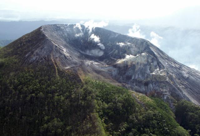 |
Figure 12. A close-up photo of Pago's ravaged summit crater taken from the N on 16 September 2002. Despite their proximity to the crater, some portions of the cone's flanks appear relatively undisturbed. Although difficult to see at the limited scale and resolution of this rendition, the original image clearly shows that a band of denuded trees remained standing within the highly disturbed zone along the breach. Many trees in a zone farther downslope were knocked flat. Courtesy of USGS-VDAP. |
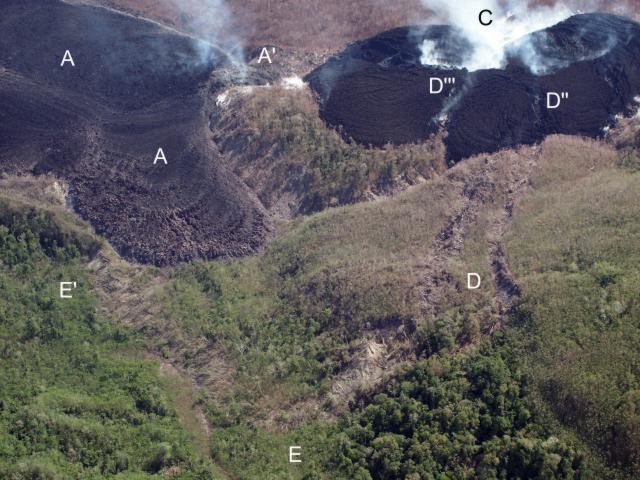 |
Figure 13. A closer view of a portion of Pago's NW outer flanks (seen in figure 3 and part of figure 5) centered on Pago's zone of intense deformation and faulting. The traces of two sub-parallel faults offset the intervening area (D) downward, forming a graben, which crosses the steep sides of older, tree-covered lavas. Farther upslope, the two faults intersect the steaming, lowermost cone (C) at several points (D'' and D'''). Downslope, the two faults join a larger system, which seems to curve back towards the massive lavas (E and E'). The massive lavas (A) discharge at the surface at a point just below A'. Courtesy of USGS-VDAP. |
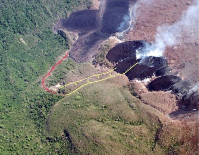 |
Figure 14. Preliminary structural interpretation by Elliot Endo of Pago's zone of intense faulting and deformation. In this interpretation, the upslope area contains a graben; the downslope area a thrust or a region of mass wasting. Courtesy of Elliot Endo, USGS-VDAP. |
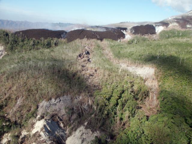 |
Figure 15. A closer view showing Pago's graben deformation feature. Earliest photographs available (~ August 15) show this feature in the early stage of development. The photo was taken looking E on 16 September 2002. For scale, mature trees midway along the fault are 10-15 m in length. Courtesy of the USGS-VDAP. |
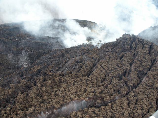 |
Figure 16. Closeup showing the extreme surface roughness of the recent Pago dacite extrusions appearing in an area near the lower vent. Large fractures sub-parallel to the vent developed during extrusion. Offsets along fractures were estimated to be as much as 5-7 m and the height of numerous adjacent points on the lava flow's surface easily varied by a meter. Courtesy of the USGS-VDAP. |
| Movie 1. Digital movie of Pago filmed from a helicopter on 6 October 2002 showing the zone of deformation and faulting followed by a views of the lava flows and vents with the summit crater in the distance towards the SSE. Courtesy of the USGS-VDAP. (30 seconds, 10.7 MB MPEG) |
During all or part of this August-October 2002 interval, lavas erupted at high rates: 10-20 m3/s. The crystal-poor dacitic lavas were roughly the same as those produced during the ancestral caldera-forming eruption. The same composition had also been consistent for the intervening lavas. By or before the end of October the current eruption had emitted ~60 x 106 m3 to ~100 x 106 m3 of magma. There was some evidence of magma mixing. Available evidence suggested that the magma rose in a dike from source depths of 6-8 km. A vital question was whether a gas-rich eruptive phase might start.
Highlighted in the August-October photos were recent faults and associated surface deformation. These had been documented by Chris McKee (Geophysical Observatory, PNG) who found that these features covered an area on Pago's mid-to-lower NW flanks. In many cases the faults left conspicuous trails marked by swaths of fallen trees across the rainforest (figures 5 and 8). Despite their clear expressions and documentation, a thermal-imaging device found that the faults and adjacent areas generally lacked anomalous high-temperature signals (Steve Saunders, RVO). The obvious exceptions to this occurred where faults cut across either vent areas and their cones or across massive lava flows in the caldera (figure 7). The inferred cause of the faulting and associated deformation was a shallow magmatic intrusion.
The USGS contributors expressed gratitude to their colleagues affiliated with Rabaul Volcano Observatory in Papua New Guinea and the West New Britain Provincial Government who had helped them with field and logistical support.
At the close of 2002 Alan Cameron (Heli Niugini) wrote Endo the following brief note. "Since you left, interest in Mt. Pago seems to have diminished; I have not flown over it for some time. Yesterday I flew a [medical evacution] past it, and smoke, etc. was still rising but the weather was bad and I did not get closer than about a half mile [(~1 km)], so I don't know what it is doing. Hoskins [airport] is still closed to aircraft, and the Talasea [air]strip is often closed due to water over it and the soft surface, so air travel is somewhat unreliable from here."
In the first week of February, Cameron sent another message. "The last time I had a close look at Pago was about a month ago. It still looked to be fairly active in most respects, however there is not much emission of ash now and the lava seems to have slowed, but I think this is on account of the flow being restricted in its exit to the [S]. To my eye it seems that the lava deposit may be increasing in height due to that restriction . . . . I do recall that there is still a great deal of heat from the lava ( I could feel its effect on the helicopter), which supports my feeling that it is building vertically and the lava is still flowing."
Reference. Cooke, R.J.S., 1981, Eruptions at Pago volcano, 1911-1933 (Compiled by R.W. Johnson), in Cooke-Ravian Volume of Volcanological Papers (editor, R.W. Johnson) Geological Survey of Papua New Guinea Memoir 10, 135-46; Printed in Hong Kong by Libra Press Ltd.
Geological Summary. The active Pago cone has grown within the Witori caldera (5.5 x 7.5 km) on the northern coast of central New Britain contains the active Pago cone. The gently sloping outer caldera flanks consist primarily of dacitic pyroclastic-flow and airfall deposits produced during a series of five major explosive eruptions from about 5,600 to 1,200 years ago, many of which may have been associated with caldera formation. Pago cone may have formed less than 350 years ago; it has grown to a height above the caldera rim, and a series of ten dacitic lava flows from it covers much of the caldera floor. The youngest of these was erupted during 2002-2003 from vents extending from the summit nearly to the NW caldera wall. The Buru caldera cuts the SW flank.
Information Contacts: Elliot Endo, John Ewert, C. Dan Miller, Andy Lockhart, Jeff Marso, and Chris Newhall, U.S. Geological Survey, David A. Johnston Cascades Volcano Observatory, Volcano Disaster Assistance Program (VDAP), 1300 SE Cardinal Ct, Building 10, Suite 100, Vancouver, WA 98683, USA; Alan Cameron, Chief Pilot, Heli Niugini Kimbe, Box 404, Kimbe WNB, Papua New Guinea; Ima Itikarai and Steve Saunders, Rabaul Volcano Observatory (RVO), Papua New Guinea; Chris Mckee, Port Moresby Geophysical Observatory, PO Box 323, Port Moresby NCD, Papua New Guinea; Hugh Davies, Earth Sciences, University of Papua New Guinea, PO Box 414, University Post Office NCD, Papua New Guinea.