Report on Manam (Papua New Guinea) — January 2003

Bulletin of the Global Volcanism Network, vol. 28, no. 1 (January 2003)
Managing Editor: Edward Venzke.
Manam (Papua New Guinea) Low-moderate seismicity after May eruption; plume on 31 October
Please cite this report as:
Global Volcanism Program, 2003. Report on Manam (Papua New Guinea) (Venzke, E., ed.). Bulletin of the Global Volcanism Network, 28:1. Smithsonian Institution. https://doi.org/10.5479/si.GVP.BGVN200301-251020
Manam
Papua New Guinea
4.08°S, 145.037°E; summit elev. 1807 m
All times are local (unless otherwise noted)
The Rabaul Volcano Observatory (RVO) reported that the Strombolian eruption from Southern Crater of Manam on 20 May (BGVN 27:05) ended the next day after the last ash-laden clouds were released. Activity then declined to emissions of very small amounts of thin white vapor. A seismograph was installed at Warisi village on the SE side of the island on 22 May 2002. This is the first seismograph to be deployed since Manam Observatory was shut down on 16 January 2001. During 22-24 May seismicity was at a moderate level, mainly associated with many low-frequency volcanic earthquakes. During 25 May-2 June seismicity declined and fluctuated at a low level. At 1351 on 31 October 2002 a pilot reported "light brown dust/smoke" from Manam drifting S toward the main coastline at an estimated height of ~3.0 km. A possible thin low-level plume was seen on satellite imagery extending ~18.5 km N at 1425 that day, but was not seen on later imagery.
MODVOLC Thermal Alerts, 2001-2002. Throughout 2001 and 2002, thermal alerts for Manam occurred only in April and May 2002. The first alert occurred on 7 April and may reflect the tail end of 14-31 March activity reported by RVO when ejection of red incandescent lava fragments was observed (BGVN 27:05). MODIS detected no thermal alerts during that period, which could be a result of cloud cover or because activity was too slight or too intermittent to have triggered an alert.
The number of alert pixels and the value of the alert ratio both increased to a peak on 20 May, the date of a moderate-sized Strombolian eruption reported by RVO. The eruption continued until about 1400 on 20 May. Subsequently, activity declined and consisted of forceful ash emission in moderate volumes (BGVN 27:05). The biggest MODIS anomaly on 20 May was detected at 1015 with 10 alert-pixels and a maximum ratio of 0.178. This is five hours after the first known report of activity. After 12 hours the anomaly was smaller with seven alert-pixels and a maximum alert ratio of -0.322. On 21 May the decreasing thermal anomaly was represented by one alert-pixel with a ratio of -0.783.
During the earlier part of May, MODIS alerts suggested noteworthy activity at Manam that has not, to our knowledge, been reported elsewhere. The anomaly dropped briefly to a minimum on 16 May, which could reflect a lull in activity or partial cloud cover.
The centers of most alert-pixels for Manam lie systematically NW of the summit (figure 11). Bearing in mind that the strongest anomaly should occur at the summit and that ejecta appears to have gone mostly to the SE (BGVN 27:05), there is likely a systematic error in geolocation for this volcano on the MODIS thermal alerts site. The shift between the reported daytime and nighttime alert locations on 20 May could be a related effect, attributable to a 20° difference in satellite zenith angle between these two passes.
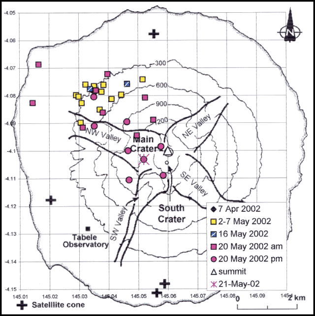 |
Figure 11. Locations of alert-pixels on Manam during 2001-2002. Grid squares are 1 km. Base map is from BGVN 21:12 (after Palfreyman and Cooke, 1976). Courtesy of Diego Coppola and David Rothery, The Open University. |
Reference. Palfreyman, W.D., and Cooke, R.J.S., 1976, Eruptive history of Manam volcano, Papua New Guinea in Johnson R.W. (ed.), Volcanism in Australasia, Elsevier, Amsterdam, p. 117-131.
Geological Summary. The 10-km-wide island of Manam, lying 13 km off the northern coast of mainland Papua New Guinea, is one of the country's most active volcanoes. Four large radial valleys extend from the unvegetated summit of the conical basaltic-andesitic stratovolcano to its lower flanks. These valleys channel lava flows and pyroclastic avalanches that have sometimes reached the coast. Five small satellitic centers are located near the island's shoreline on the northern, southern, and western sides. Two summit craters are present; both are active, although most observed eruptions have originated from the southern crater, concentrating eruptive products during much of the past century into the SE valley. Frequent eruptions, typically of mild-to-moderate scale, have been recorded since 1616. Occasional larger eruptions have produced pyroclastic flows and lava flows that reached flat-lying coastal areas and entered the sea, sometimes impacting populated areas.
Information Contacts: Ima Itikarai, Rabaul Volcano Observatory (RVO), P.O. Box 386, Rabaul, Papua New Guinea; Darwin VAAC, Bureau of Meteorology, Northern Territory Regional Office, PO Box 40050, Casuarina Northern Territory 0811 Australia (URL: http://www.bom.gov.au/info/vaac/); Diego Coppola and David A. Rothery, Department of Earth Sciences, The Open University, Milton Keynes, MK7 6AA, United Kingdom.