Report on Ulawun (Papua New Guinea) — January 2003

Bulletin of the Global Volcanism Network, vol. 28, no. 1 (January 2003)
Managing Editor: Edward Venzke.
Ulawun (Papua New Guinea) Intermittent ash plumes from August through early November 2002
Please cite this report as:
Global Volcanism Program, 2003. Report on Ulawun (Papua New Guinea) (Venzke, E., ed.). Bulletin of the Global Volcanism Network, 28:1. Smithsonian Institution. https://doi.org/10.5479/si.GVP.BGVN200301-252120
Ulawun
Papua New Guinea
5.05°S, 151.33°E; summit elev. 2334 m
All times are local (unless otherwise noted)
During mid-March 2002 through at least early February 2003, activity from the main crater and the N valley vents of Ulawun were unchanged and generally remained low. The vent in the main crater released weak-to-moderate volumes of white and white-gray vapor. The N valley vents sometimes produced very weak traces of thin white vapor. Seismicity returned to background levels after volcanic tremors ceased on 18 March 2002. Discrete low-frequency earthquakes continued to occur in small numbers. During 15-28 April the seismicity level was low, however from 29 April seismicity increased to a moderate level following an episode of continuous volcanic tremor. The tremor ceased on 25 May. In June, RVO reported that the electronic tiltmeter continued to show long-term deflation of the summit area, but the amount of change was smaller than in the previous 1-3 months. Small continuous volcanic tremors became more prominent beginning on 21 January 2003 and ceased on 27 January.
Satellite imagery showed eruption plumes on 22 and 28 August (news reports indicated continued activity that entire week), and 6-7 September 2002 (BGVN 27:08). The Darwin VAAC issued advisories about low-level ash plumes on 12 and 19 September, and an ash-and-steam cloud to ~3.7 km on 28 September. Low-level ash plumes were noted again on 2 and 16 October, with another higher plume (~3.6 km) on the 22nd. At 0630 on 3 November an Air Niugini pilot reported ash drifting ESE from the volcano at ~3 km altitude.
MODVOLC Thermal Alerts, 2001-2002. Throughout 2001 and 2002, thermal alerts for Ulawun occurred only during 26-28 April 2001. The first detected anomaly was at 2225 on 26 April and consisted of four alert-pixels with a maximum alert ratio of -0.095. By the following day the anomaly had increased in spatial dimension to eight alert-pixels although the maximum alert ratio was lower (-0.224). On 28 April at 2215 the anomaly had increased to 15 alert-pixels with a higher maximum alert ratio of -0.053. After that no more anomalies were detected.
This sequence can be related to events reported by the Rabaul Volcano Observatory (BGVN 26:06) On 26 April 2001 at 0530 a small Strombolian eruption began. This was characterized by glowing lava fragments ejected by frequent explosions followed by small pyroclastic flows. During the day activity decreased but on 27 April at 0530 another phase of Strombolian activity began. A small pyroclastic flow occurred followed by a lava flow that descended to about 500-600 m above sea-level. This is presumably the cause of the 15-pixel alert on 28 April (figure 8). A third phase of Strombolian activity began at about 0600 on 29 April. This phase was slower and more gradual, peaking at about 1800-2200 on 29 April, and did not produce a MODIS thermal alert.
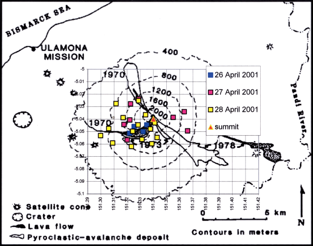 |
Figure 8. Locations of MODIS alert-pixels on Ulawun during 2001-2002. Courtesy of Diego Coppola and David Rothery, The Open University. |
Geological Summary. The symmetrical basaltic-to-andesitic Ulawun stratovolcano is the highest volcano of the Bismarck arc, and one of Papua New Guinea's most frequently active. The volcano, also known as the Father, rises above the N coast of the island of New Britain across a low saddle NE of Bamus volcano, the South Son. The upper 1,000 m is unvegetated. A prominent E-W escarpment on the south may be the result of large-scale slumping. Satellitic cones occupy the NW and E flanks. A steep-walled valley cuts the NW side, and a flank lava-flow complex lies to the south of this valley. Historical eruptions date back to the beginning of the 18th century. Twentieth-century eruptions were mildly explosive until 1967, but after 1970 several larger eruptions produced lava flows and basaltic pyroclastic flows, greatly modifying the summit crater.
Information Contacts: Ima Itikarai, Rabaul Volcano Observatory (RVO), P.O. Box 386, Rabaul, Papua New Guinea; Darwin Volcanic Ash Advisory Center (VAAC), Bureau of Meteorology, Northern Territory Regional Office, PO Box 40050, Casuarina, NT 0811, Australia (URL: http://www.bom.gov.au/info/vaac/); Diego Coppola and David A. Rothery, Department of Earth Sciences, The Open University, Milton Keynes, MK7 6AA, United Kingdom.