Report on Fuego (Guatemala) — January 2003

Bulletin of the Global Volcanism Network, vol. 28, no. 1 (January 2003)
Managing Editor: Edward Venzke.
Fuego (Guatemala) Explosive eruptions from September 2002 through January 2003
Please cite this report as:
Global Volcanism Program, 2003. Report on Fuego (Guatemala) (Venzke, E., ed.). Bulletin of the Global Volcanism Network, 28:1. Smithsonian Institution. https://doi.org/10.5479/si.GVP.BGVN200301-342090
Fuego
Guatemala
14.4748°N, 90.8806°W; summit elev. 3799 m
All times are local (unless otherwise noted)
Explosions, ash emission, and lava flows took place during January-February and July 2002 (BGVN 27:08). MODIS thermal alerts were recorded monthly throughout 2002. CONRED reported that during the last 3 months of 2002, a change in behavior at Fuego was characterized by an increase in Strombolian activity. Ash emission and pyroclastic flows threatened communities to the SW, which prepared for evacuation (figure 5). This report covers the period of 26 December 2002 through mid-January 2003.
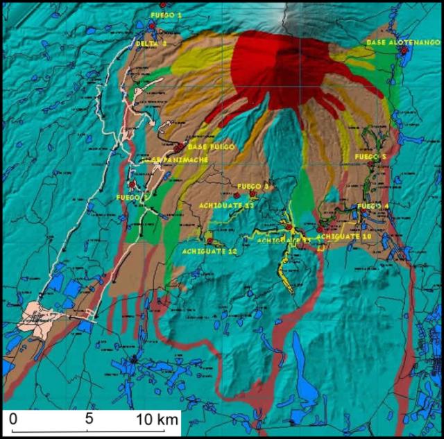 |
Figure 5. This condensed-format map of Fuego hazards was intended as a poster when created by the Guatemalan agency CONRED. North is towards the top; the original map key and credits are truncated from this version. The map shows six different hazard zones with a gradation of expected hazards, as well as some of the critical close-in population centers and their suggested departure routes. The large population center Antigua lies off the map, 17 km NE of Fuego's summit. Courtesy of CONRED. |
According to news reports, an explosive eruption and partial crater collapse occurred on 26 December 2002 around 0905. An ash cloud was generated that reached ~2 km above the volcano and drifted W toward the Yepocapa region. Neither damage nor injuries were reported.
The Washington VAAC reported that an eruption began at Fuego on 8 January 2003 around 0500. According to INSIVUMEH, as of 1100 that day the eruption continued with ash explosions and lava flow emission. A steam-and-ash column rose to 5.7 km altitude and drifted to the W. In addition, two small-to-moderate pyroclastic flows traveled down the Santa Teresa river valley. Seismic signals continued to show evidence of magma ascent, but fewer in number with 15-25 explosions per minute recorded. This suggested continued effusive emissions for a number of hours. During the eruption, ash fell in an elliptical area chiefly W of Fuego; other events included rumbling, and fumarolic activity. CONRED stated that the Alert Level was raised to Orange and several people were evacuated from the town of Sangre de Cristo. According to a news report volcanism decreased the following day, so the Alert Level was lowered from Orange to Yellow.
INSIVUMEH reported that as of 19 January moderate eruptions continued at Fuego that produced ash clouds to 1.5-3 km altitude. Ash drifted to the S and SW, depositing fine ash in the areas of Rocela, Panimache, and Palo Verde. In addition, incandescent avalanches traveled down canyons on the volcano's flanks. Table 2 shows ash advisories issued for Fuego by the Washington VAAC during January.
Table 2. Volcanic ash advisories issued for Fuego during January 2003. Courtesy Washington VAAC.
| Date | Time (UTC) | Observation |
| 08 Jan 2003 | 1640 | Satellite imagery showed a vivid hot spot. A possible ash plume was observed moving W from the summit at 1545Z. By 1615Z the narrow plume extended ~18 km to the W of the summit. |
| 08 Jan 2003 | 2010 | Satellite imagery through 1945Z showed a larger eruption occurring with ash estimated to FL200 (6 km). The bulk of the ash was moving N but some moved W. The initial ash plume had detached and was moving W toward the coast. |
| 09 Jan 2003 | 0200 | Ash was not visible in nighttime infrared or multispectral imagery. The last visible image of the day showed ash to the W and NW of the summit moving at 18-28 km/hour. Guatemala City airport reported continuing eruptions. |
| 09 Jan 2003 | 0755 | Ash was not visible in infrared of multispectral imagery through 0715Z. Imagery showed a strong and persistent hot spot. Guatemala City airport reported continuous eruptions. |
| 09 Jan 2003 | 1400 | Ash was not visible in infrared or multispectral imagery through 1315Z. A persistent strong hot spot continued in shortwave imagery. |
| 09 Jan 2003 | 1915 | Ash too thin to be detected in satellite imagery. An occasional hot spot was detected in short wave imagery. |
| 11 Jan 2003 | 1610 | Thin faint ash plume seen in satellite imagery extending W from the volcano ~83 km. |
| 11 Jan 2003 | 2150 | Ash not identifiable in satellite imagery. Surface reports from Guatemala city through 2100Z continued to indicate that the volcano was active. A hot spot continued to be observed in satellite imagery. |
| 12 Jan 2003 | 0400 | Ash not identifiable in satellite imagery. No further reports from Guatemala. Hot spot continued to be observed in satellite imagery. |
| 12 Jan 2003 | 1030 | Ash not identifiable in satellite imagery. Surface reports from Guatemala City indicated that Fuego was active. An intermittent hot spot was seen in satellite imagery. |
| 12 Jan 2003 | 1615 | Ash not identified in satellite imagery and no hotspot was seen at the summit. Surface reports indicated continuing activity. |
| 20 Jan 2003 | 0430 | A report from the Guatemala Volcano Institute indicated that ongoing activity produced an ash cloud to 2 km above the summit (~5.8 km altitude) moving S and SW. Multi-spectral imagery showed the ash in a 18-km-wide line extending ~33 km from the summit. The report also indicated that ash was falling in the areas of La Rochela, Panimache, and Palo Verde. |
| 20 Jan 2003 | 1030 | Ash plume became diffuse and difficult to see on multi-spectral imagery. Around 530Z another puff of ash was seen moving to the SW and an intermittent hotspot was visible for the past few hours. |
| 20 Jan 2003 | 1630 | Exhalation of ash and steam at 0615Z. Ash plume diffuse and difficult to see on satellite imagery. |
Observations during 3-13 January 2003. Craig Chesner and Sid Halsor reported continuous low-level volcanic activity and one larger event at Fuego during a 10-day site visit. Nearly continuous Strombolian-type spattering and fountaining were observed during the night of 3 January. Bombs and blocks, ejected up to several tens of meters above the summit vent, fell on the upper flanks. No ash was observed during this activity, although ashy trails were generated from ejecta tumbling down the steep southern and eastern slopes of the volcano. On 4 January, no lava fountaining was observed, and activity was characterized by steady and passive emission of a gas plume.
Energetic fountaining and spattering were observed during the night of 5 January from a vantage point on the summit of nearby Agua volcano. Fourteen Strombolian explosions occurred at intervals of 5-61 minutes during 5 hours of continuous observation. These explosions ejected incandescent material ~100 m above the cone, showering the upper flanks with blocks and bombs. Typically, each explosion was accompanied by a loud detonation and an ash plume, and led to several minutes of vigorous fountaining. This activity continued during the morning of 6 January, but by evening, no incandescent activity was apparent at the summit vent.
On the morning of 7 January, a new lava flow was noted on the southern flank, and ash trails generated from spalling blocks suggested that it was active. In the evening, vigorous lava fountaining and spattering had resumed, and the lava flow was seen descending from the summit area to the S. A nearly continuous cascade of pyroclasts produced incandescent rock falls on the upper flanks of the cone.
At 1030 on 8 January, an expansive plume of ash had developed over the summit area. Concurrent fountaining and pulsating eruptions of ash were observed from a vantage point near Alotenango, a few kilometers NE of the volcano. By 1100, the eruption column was broadening at its base, darkening in color, and extending to considerable height above the summit. The most intense phase of the eruption occurred roughly between 1145 and 1215 (figure 6). During this time, loud rumbling and swashing-like sounds accompanied continuous fountaining and frequent, energetic eruptions of ash. A bright incandescent fire fountain, several tens of meters high, was clearly observed at the base of the ash column. Twice during this time period, lateral ash columns, presumably associated with pyroclastic flows, were noted descending towards the W. A convective column engulfed the summit area and appeared to rise several kilometers to an altitude of ~2-3 times the height of the cone.
 |
Figure 6. Image of Fuego eruption taken on 8 January around 1200. View looking W from about 10 km away. The eruption cloud was dispersed westward and the ground-hugging smaller cloud just W from the summit area may have been associated with reported pyroclastic flows. Courtesy Sid Halsor. |
By 1245, eruptive activity appeared to subside with eruptions becoming less frequent and gradual lightening in color of the ash cloud. Throughout the afternoon, the ash cloud drifted westward and dispersed ash-laden air over a broad region. A circumnavigation of the volcano during the afternoon indicated no detectable ash fall along the dispersal axis at a distance of ~9 km. However, a slight discoloration of vegetation was noted to the E of Yepocapa. Intermittent low to moderate ash eruptions continued throughout the day and summit fountaining was observed at night. The following morning (9 January), no visible activity was noted over a brief observational period. However, the summit area surrounding the vent had clearly changed, being asymmetrically higher to the NW. From 10-13 January, activity was characterized by periodic low-level Strombolian explosions and associated ash plumes. These plumes could be seen from as far away as western El Salvador.
Geological Summary. Volcán Fuego, one of Central America's most active volcanoes, is also one of three large stratovolcanoes overlooking Guatemala's former capital, Antigua. The scarp of an older edifice, Meseta, lies between Fuego and Acatenango to the north. Construction of Meseta dates back to about 230,000 years and continued until the late Pleistocene or early Holocene. Collapse of Meseta may have produced the massive Escuintla debris-avalanche deposit, which extends about 50 km onto the Pacific coastal plain. Growth of the modern Fuego volcano followed, continuing the southward migration of volcanism that began at the mostly andesitic Acatenango. Eruptions at Fuego have become more mafic with time, and most historical activity has produced basaltic rocks. Frequent vigorous eruptions have been recorded since the onset of the Spanish era in 1524, and have produced major ashfalls, along with occasional pyroclastic flows and lava flows.
Information Contacts: Gustavo Chigna M. and Otoniel Matías, Instituto Nacional de Sismologia, Vulcanologia, Meteorologia e Hidrologia (INSIVUMEH), Ministero de Communicaciones, Transporto, Obras Públicas y Vivienda, 7a. Av. 14-57, zona 13, Guatemala City 01013, Guatemala (URL: http://www.insivumeh.gob.gt/); Juan Pablo Ligorria, Coordinadora Nacional para la Reducción de Desastres (CONRED), Av. Hincapié 21-72, Zona 13, Guatemala City, Guatemala; Washington Volcanic Ash Advisory Center, NOAA Satellite Services Division, NESDIS E/SP23, NOAA Science Center, Room 401, 5200 Auth Road, Camp Springs, MD 20746, USA (URL: http://www.ospo.noaa.gov/Products/atmosphere/vaac/); Craig A. Chesner, Geology/Geography Department, Eastern Illinois University, Charleston, IL 61920, USA; Sid P. Halsor, GeoEnvironmental Science and Engineering, Wilkes University, Wilkes-Barre, PA 18766; EFE via COMTEX, Prensa Libre, Siglo XXI.