Report on Cerro Blanco (Argentina) — May 2003
Bulletin of the Global Volcanism Network, vol. 28, no. 5 (May 2003)
Managing Editor: Edward Venzke.
Cerro Blanco (Argentina) Satellite surveys during May 1996-October 2000 indicate subsidence
Please cite this report as:
Global Volcanism Program, 2003. Report on Cerro Blanco (Argentina) (Venzke, E., ed.). Bulletin of the Global Volcanism Network, 28:5. Smithsonian Institution. https://doi.org/10.5479/si.GVP.BGVN200305-355210
Cerro Blanco
Argentina
26.7657°S, 67.746°W; summit elev. 4670 m
All times are local (unless otherwise noted)
A satellite-based interferometric synthetic aperture radar (InSAR) survey of the remote central Andes volcanic arc (Pritchard and Simons, 2002) revealed deformation in the Robledo caldera between May 1992 and October 2000 (figure 1). Subsidence was detected, with a maximum deformation rate in the radar line-of-sight of 2-2.5 cm/year. The subsidence rate seemed to be decreasing with time. The inferred source depth was 4.5-6 km below sea level. Additional details about the study and analysis are available in Pritchard and Simons (2002).
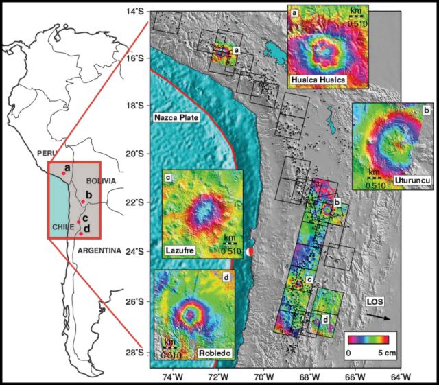 |
Figure 1. Shaded relief topographic map of the central Andes with insets showing areas of deformation detected by Pritchard and Simons (2002). Interferograms (draped over shaded relief) indicate active deformation; each color cycle corresponds to 5 cm of deformation in the radar line-of-sight (LOS). The LOS direction from ground to spacecraft (black arrow) is inclined 23° from the vertical. Black squares indicate radar frames, and black triangles show potential volcanic edifices. Courtesy of Matthew Pritchard. |
Reference. Pritchard, M., and Simons, M., 2002, A satellite geodetic survey of large-scale deformation of volcanic centres in the Central Andes: Nature, v. 418, p. 167-170.
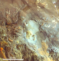
Geological Summary. The Cerro Blanco volcanic complex contains the 5-km-diameter Cerro Blanco (or Robledo) caldera in NW Argentina, 80 km SW of the Cerro Galán caldera. Cerro Blanco was the site of the largest known Holocene eruption in the Central Andes about 4,200 years BP (Fernandez-Turiel et al., 2013). The rhyolitic Plinian eruption produced ashfall over about 110 km3 and widespread ignimbrite deposits. The large Cerro Blanco del Robledo lava dome overgrew the SW rim of the caldera and is surrounded by extensive rhyolitic pumice-fall deposits. Satellite geodetic surveys in the central Andes (Pritchard and Simons, 2002) showed subsidence of the caldera in the 1990s.
Information Contacts: Matthew Pritchard and Mark Simons, Division of Geological and Planetary Sciences, California Institute of Technology, Pasadena, CA 91125, USA (URL: http://www.gps.caltech.edu/).