Report on Deception Island (Antarctica) — June 2003
Bulletin of the Global Volcanism Network, vol. 28, no. 6 (June 2003)
Managing Editor: Edward Venzke.
Deception Island (Antarctica) Fieldwork shows moderate seismicity and stable fumarole temperatures
Please cite this report as:
Global Volcanism Program, 2003. Report on Deception Island (Antarctica) (Venzke, E., ed.). Bulletin of the Global Volcanism Network, 28:6. Smithsonian Institution. https://doi.org/10.5479/si.GVP.BGVN200306-390030
Deception Island
Antarctica
62.9567°S, 60.6367°W; summit elev. 602 m
All times are local (unless otherwise noted)
While fieldwork was conducted during 1 December 2002-18 April 2003, Spanish and Argentine scientists measured Deceptions Island's seismicity, thermal activity, and gas emissions. Gravimetric field surveys, geodetic measurements, and geological studies were also carried out.
Monitoring during 2002-2003. During the 2002-2003 Antarctic summer the scientists installed two dense seismic antennas in trigger mode and four continuous-recording short-period stations (figure 19). Each of the antennae were composed of eight short-period seismometers with apertures of ~250 m. One was located at the Argentinean Base and the other in Pendulum Cove. Three vertical-component seismometers were located on the N side of Fumarole Bay, at the beach between Murature Point and Cross Hill, and near 70'Craters. Finally, a three-component seismic station was installed near the Spanish Station.
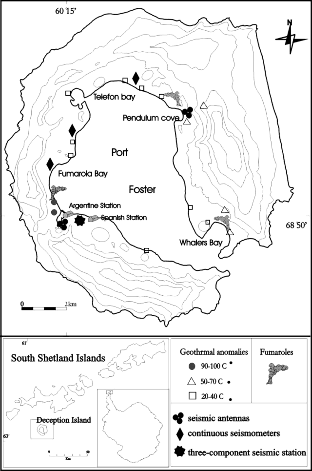 |
Figure 19. Map of Deception Island indicating seismic stations, antennas, fumaroles, and geothermal anomalies measured during 1 December 2002-18 April 2003. Courtesy of A. T. Caselli. |
The recorded seismicity included volcano-tectonic earthquakes (VT), long-period events (LP), and a few episodes of volcanic tremor. More than 56 VT and 700 LP events were recorded, 54 of them with hybrid character; 55 recorded tremor episodes had durations ranging from less than one hour to eight hours. The recording period could be divided into two different phases on the basis of the degree of activity. The first, from 22 December until the beginning of March, was characterized by a relatively high level of activity with frequent VT earthquakes, LP events, and volcanic tremors. The second phase, from the beginning of March until 4 April, was characterized by a similar rate of VT earthquakes but fewer LP events and tremor. This observation supported the idea that LP seismicity might be related to seasonal thaw water. Most earthquakes were centered on the island, in accord with their VT designation. Compared to previous surveys, the 2002-2003 level of seismicity was considered to be moderate
Temperatures of fumaroles and hot soils remained stable at 99-101°C in Fumarole Bay, 95°C in Caliente Hill, 65°C in Whalers Bay, 41°C in Telefon Bay, and 72°C in Pendulum Cove (figure 19). Fumarolic activity was also monitored, with radon measurements being made for the first time. Standard wet-analysis techniques revealed that the composition of gas obtained from the vents at Fumarole Bay was similar to that of recent years, namely H2O(v) (70-95%), CO2 (7-29%), H2S (0.12-0.39%), and SO2 (0.01-0.07%). Elemental sulfur was seen around the vent outlets, and pyrite with lapilli coatings were found at a few centimeters depth.
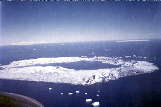
Geological Summary. Ring-shaped Deception Island, at the SW end of the South Shetland Islands, NE of Graham Land Peninsula, was constructed along the axis of the Bransfield Rift spreading center. A narrow passageway named Neptunes Bellows provides an entrance to a natural harbor within the 8.5 x 10 km caldera that was utilized as an Antarctic whaling station. Numerous vents along ring fractures circling the low 14-km-wide island have been reported active for more than 200 years. Maars line the shores of 190-m-deep Port Foster caldera bay. Among the largest of these maars is 1-km-wide Whalers Bay, at the entrance to the harbor. Eruptions during the past 8,700 years have been dated from ash layers in lake sediments on the Antarctic Peninsula and neighboring islands.
Information Contacts: A.T. Caselli, M.R. Agusto, and L. Ferreyra, Universidad de Buenos Aires-Instituto Antártico Argentino, Ciudad Universitaria, Pab.2, (1428) Buenos Aires, Argentina; Jesús Ibáñez, Daria Zandomeneghi, Daniel Stich, Francisco Carrión, and Javier Almendros, Instituto Andaluz de Geofísica, Universidad de Granada, 18071-Granada, Spain.