Report on Sierra Negra (Ecuador) — September 2004
Bulletin of the Global Volcanism Network, vol. 29, no. 9 (September 2004)
Managing Editor: Richard Wunderman.
Sierra Negra (Ecuador) 12 June-29 August 2004, GPS data indicate 77 cm of caldera-floor uplift
Please cite this report as:
Global Volcanism Program, 2004. Report on Sierra Negra (Ecuador) (Wunderman, R., ed.). Bulletin of the Global Volcanism Network, 29:9. Smithsonian Institution. https://doi.org/10.5479/si.GVP.BGVN200409-353050
Sierra Negra
Ecuador
0.83°S, 91.17°W; summit elev. 1124 m
All times are local (unless otherwise noted)
Sierra Negra volcano contains a six-station, continuously monitored GPS network. The instruments were installed in collaboration with a research consortium (UNAVCO) in May 2002 (figure 2).
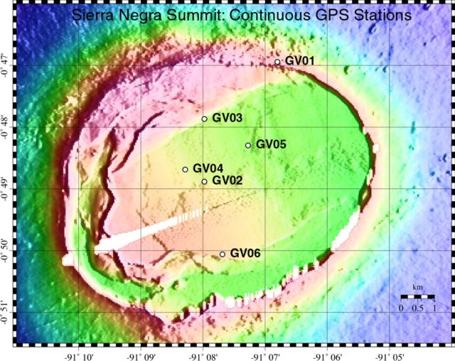 |
Figure 2. The summit of Sierra Negra has this dedicated GPS system continuously monitoring deformation. The shading reflects ground surface elevations; although a key to elevations was not provided, the map makes evident the caldera's broad floor and circular form. Courtesy of Geist, Chadwick, and Johnson. |
Starting on 12 June 2004 and continuing through at least 29 August 2004, the rate of uplift of the caldera floor, as measured by this network, had accelerated to 77 cm/year (table 1). This rate was comparable to that inferred from InSAR data in the late 1990s (Amelung and others, 2000). That late 1990's uplift was attributed to trap-door faulting of the caldera floor along its southern margin, a process presumably driven by a shallow (< 2 km) intrusion of magma. Deflation occurred during 2001-2002, and slower uplift of about 12 cm/y prevailed during March 2003-May 2004 (table 1). The 12 June-29 August interval was noteworthy for the high rates of uplift (table 1).
Table 1. A summary of the geophysically derived movement of the caldera floor at Sierra Negra. Courtesy of Dennis Geist, William Chadwick, and Dan Johnson.
| Interval | Comments | Measurement Technique |
| 1992-1998 | 240 cm of uplift punctuated by trapdoor uplift in 1997 or 1998 | InSAR (Amelung and others, 2000) |
| 1998-1999 | Inflation at 65 cm/year | InSAR (Amelung and others, 2000) |
| 2000-2001 | Deceleration of uplift to 7 cm/year | Campaign GPS (Geist and others, submitted) |
| 2001-Feb 2003 | Deflation of ~9 cm/year | Campaign and continuous GPS |
| Mar 2003-May 2004 | Inflation at ~12 cm/year | Continuous GPS |
| 12 Jun-29 Aug 2004 | Inflation at 77 cm/year | Continuous GPS |
The Instituto Geofísico in Quito, Ecuador monitors seismic activity in the Galápagos, using a network that includes a single station on Sierra Negra. Unfortunately, that network was down for the past year, in need of a variety of hardware, including the seismometer at Sierra Negra. Thus, for the interval of interest, seismic data were absent. Hugo Yepes estimated that to repair the Galápagos system would require about $9,000 (USD) in equipment and $4,000 (USD) in personnel transport and field expenses. He also said that the region requires more stable long-term logistical support.
The 12 June-29 August 2004 uplift was symmetrical about the caldera's center. The pattern and rate of uplift was well modeled as a 2.1 km deep sill intruded by about 12 x 106 m3 of magma since June 2004.
Sierra Negra last erupted in 1979, when nearly 1 km3of lava erupted from a circumferential fissure near the summit, covering its N flank./p>
References. Amelung, F., Jonsson, S., Zebker, H., Segall, P., 2000. Widespread uplift and "trapdoor" faulting on Galápagos volcanoes observed with radar interferometry. Nature 407, 993-998.
Geist, D., Chadwick, W.W., and Johnson, D., Results from new GPS and gravity monitoring networks at Fernandina and Sierra Negra volcanoes, Galápagos, 2000-2002 (submitted to the Journal of Volcanology and Geothermal Research in 2004).
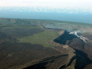
Geological Summary. The broad shield volcano of Sierra Negra at the southern end of Isabela Island contains a shallow 7 x 10.5 km caldera that is the largest in the Galápagos Islands. Flank vents abound, including cinder cones and spatter cones concentrated along an ENE-trending rift system and tuff cones along the coast and forming offshore islands. Although it is the largest of the five major Isabela volcanoes, it has the flattest slopes, averaging less than 5° and diminishing to 2° near the coast. A sinuous 14-km-long, N-S-trending ridge occupies the west part of the caldera floor, which lies only about 100 m below its rim. The Volcán de Azufre fumarolic area lies within a graben between this ridge and the west caldera wall. Lava flows from a major eruption in 1979 extend all the way to the north coast from circumferential fissure vents on the upper northern flank.
Information Contacts: Dennis J. Geist, Department of Geological Sciences, University of Idaho, Moscow, Idaho 83844-3022 USA; William W. Chadwick, Jr., Cooperative Institute for Marine Resources Studies (CIMRS), NOAA Pacific Marine Environmental Laboratory (PMEL), 2115 SE OSU Drive, Newport, OR 97365 USA; Daniel J. Johnson, University of Puget Sound, Department of Geology, 1500 N. Warner, Tacoma, WA 98416, USA; Hugo Yepes, Geophysical Institute (IG), Escuela Politécnica Nacional, Apartado 17-01-2759, Quito, Ecuador (URL: http://www.igepn.edu.ec/).