Report on Asamayama (Japan) — January 2005
Bulletin of the Global Volcanism Network, vol. 30, no. 1 (January 2005)
Managing Editor: Richard Wunderman.
Asamayama (Japan) 1 September 2004 eruption followed by others at least as late as 14 November
Please cite this report as:
Global Volcanism Program, 2005. Report on Asamayama (Japan) (Wunderman, R., ed.). Bulletin of the Global Volcanism Network, 30:1. Smithsonian Institution. https://doi.org/10.5479/si.GVP.BGVN200501-283110
Asamayama
Japan
36.406°N, 138.523°E; summit elev. 2568 m
All times are local (unless otherwise noted)
At 2020 on 1 September 2004, an explosive eruption occurred from the summit crater of Asama (BGVN 29:08 and 29:10). As previously reported, the resulting eruption cloud drifted NE, and ash fell ~250 km away. A Reuters news report stated that this was its biggest eruption in 21 years (since April 1983). A distinct plume was still discharging on 3 September, when Asia Air Surveys took a vertical aerial photograph (figures 22 and 23).
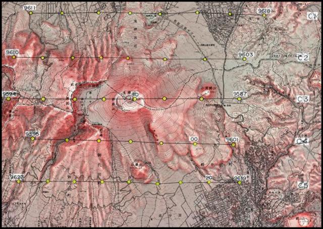 |
Figure 22. Topographic map showing the flight lines and locations of aerial photos at Asama volcano (N is towards the top), 3 September 2004. Courtesy of Asia Air Survey Co., Ltd. |
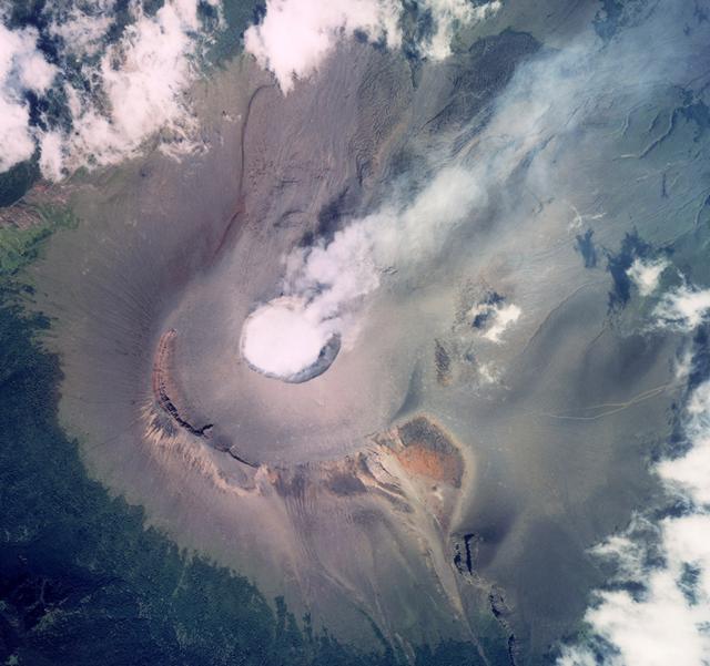 |
Figure 23. Aerial photo of Asama taken on 3 September 2004; the shot was taken at the point labeled "90" on line C3 on figure 22, in effect, from a point slightly E of the summit crater. Copyrighted photo is used here with permission of Asia Air Survey Co., Ltd. (their photo number C3-9590). |
Setsuya Nakada and Yukio Hayakawa informed Bulletin editors of Asama's eruptions by preparing reports and outlines in English, or explaining the significance of several kinds of data that were not otherwise accessible in English. Investigators plan to present data on Asama's 2004 eruptions at upcoming conferences, including The Joint Geoscience Meeting, to be held in May 2005 at Makuhari, Chiba (Japan).
A small eruption around 1530 on 14 September (figure 24) produced an ash plume that rose 1-2.5 km above the volcano. A smaller eruption earlier that day around 0328 produced a plume that rose ~300 m. A small amount of ash fell in Takasaki, ~45 km from the volcano.
 |
Figure 24. A drifting eruption cloud emitted at Asama, as seen from the Geological Society of Japan office building in Tsukuba, ~150 km E of the volcano. Taken at 1751 on 14 September. Courtesy of A. Tomiya, GSJ. |
Asama erupted almost continuously for a third straight day on 16 September (figure 25), associated with more than 1,000 earthquakes. Incandescent fragments were ejected ~300 m from the summit and ash columns rose ~1,200 m above the crater. Late that night, winds carried ash as far as central Tokyo, ~140 km SE. The frequency of the eruptions appeared to have tapered off by the afternoon of the 17th. Television footage at that time showed gray smoke mixed with ash billowing over the mountain. Minor ash eruptions occurred intermittently until 2103 on 18 September; ash clouds drifted E. Ashfall covered the southern part of the Kanto area, more than 150 km from the volcano.
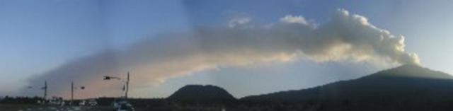 |
Figure 25. A panoramic photograph of Asama taken 16 September 2004 looking from Asama's NE flank. Courtesy of Michiko Owada, GSJ. |
By 18 September, the Japan Meteorological Agency (JMA) was reporting that ash plumes were still rising ~1,200 m, but only about 23 small eruptions and nearly 140 tremors had been recorded that afternoon, a significant change from the nearly continuous activity of the previous few days. The hazard status remained at 3 on a scale of 5, suggesting more small-to-medium eruptions might occur.
An analysis of crater morphology based on airborne radar conducted on 16 September confirmed a new lava dome there. According to JMA and the Geographical Survey Institute this was the first dome since 1973. Mid-September radar images showed the growth of a broad (pancake-shaped) layered form reaching several dozen meters high with a radius of ~100 m in the NE part of the crater; its volume was ~500,000 m3. Compelling images showcasing the side-looking airborne (SAR) radar method and depicting the dome can be seen on the GSI website (but as of early 2005 almost all the text remained in Japanese).
A moderate explosive eruption occurred at 1944 on 23 September. Small amounts of ash and lapilli were deposited NE of Asama.
Many (not all) parts of the world now have Volcanic Ash Advisory Centers (VAACs) devoted to helping aviators avoid volcanic ash. They operate through agencies closely associated with aviation meteorology. The Tokyo VAAC website presents a diagram showing some fundamental linkages in its information management networks (figure 26). The diagram is only intended to provide an introductory overview (e.g., it is not comprehensive, and it may be outdated); however, it should make the role of the Tokyo VAAC in the Asama eruption more tangible to many in the volcano-monitoring community.
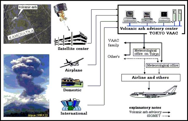 |
Figure 26. A schematic showing some paths of information flow into and out of the Tokyo VAAC. The real communication patterns are considerably more complex and involve other communication links, such as those of the air carrier, between its aircraft to its own offices, and those directly between local observatories and meteorological offices. Inputs from people monitoring a volcano pass through a system with different conventions and procedures. Modified from a diagram on the Tokyo VAAC website. |
Volcano-monitoring input can pass to the VAAC via the paths labeled Domestic (in this case, Japan) and International (including the Kamchatkhan Volcanic Eruptions Response Team, the Philippine Institute of Volcanology and Seismology, the Alaska Volcano Observatory, and adjacent VAACs of Washington, Anchorage, and Darwin). In some examples of the latter communications, one VAAC may alert others that an ash plume may soon extend beyond the boundary of VAAC's area of responsibility. Sources of incoming data include that from satellites and from aircraft. The latter includes both PIREPS, pilot reports, and AIREPs, air reports routed via airlines. The VAAC prepares output to aviators that includes both Volcanic Ash Advisories and SIGMETS. The latter, SIGnificant METeorological messages contain information about hazardous phenomena, including weather, severe icing, turbulence, or volcanic ash that, in the judgment of the forecaster, are hazardous to aviation). The system continues to undergo refinement and exists under the auspices of the International Civil Aviation Organization (ICAO).
Tokyo VAAC reported that eruptions during 23-25 September produced plumes, in some cases to unknown heights; and in one case to "FL 170" (aviation shorthand for 17,000 feet; ~5 km altitude; figure 27). In addition, minor ash eruptions occurred twice on 1 October. Afterwards a helicopter flight provided by the Nagano police (Shinshu) was carried out under conditions of clear sky with southerly winds, enabling observers to watch Asama's summit area during the hours of 0930-1100. They saw relatively weak emissions drifting N. A new vent, ~70 m in diameter and ~40 m in depth lay within the summit (Kamayama) crater. This was in accord with what had been observed on 16 and 17 September by radar (SAR image of GSI) and also photographed by the press (Eg., Yomiuri Shimbun). From the eastern rim of the vent a crack of incandescence was observed, from which a jet of volcanic gas issued intermittently. Using an infrared camera, the highest temperature JMA measured was 517°C.
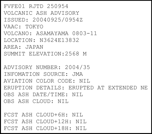 |
Figure 27. A Volcanic Ash Advisory issued by Tokyo VAAC describing a 25 September 2004 eruption at Asama that sent ash to ~5 km altitude (FL 170). Advisories such as this are the messages received on the flight deck of potentially affected aircraft and by the air carriers' dispatchers. Courtesy of the Tokyo VAAC. |
A minor explosive eruption occurred at 2310 on 10 October. Small amounts of ash and lapilli were deposited NNE of the volcano. The Tokyo VAAC reported this eruption produced a plume to an unknown height.
The Tokyo VAAC reported an eruption on 16 October at 1206; it discharged a SE-drifting ash cloud higher than 3.4 km altitude. On 18 October at 1017, a N-drifting plume rose to ~3.4 km altitude.
Asama erupted with a loud explosion on 14 November at 2059. JMA rated the eruption as mid-sized, 3 on a scale of 5, in terms of power of the explosion. The agency issued a warning of falling ash downwind of the volcano, although no ash plume was observed due to cloudy weather conditions. Following the explosion observers did see falling rocks over a large area on the volcano's slopes. There were no immediate reports of injuries or damage. Ash and lapilli were deposited E of Asama and ash-fall covered the N part of the Kanto area, reaching more than 100 km.
Other tilt, GPS, seismic, and gravity data. A tilt anomaly was observed and announced by JMA on 22 February, but no eruption occurred. That inflation took place over about 3 months, beginning 14 November 2004. The series of eruptions in September 2004 was preceded by earthquake swarms and shorter-term tilt changes. The respective anomalies became significant a few days to half a day before the explosive events. Tiltmeters of JMA and ERI are located ~3 km N and ~4 km E of the summit crater. The former are more sensitive than the latter, probably due to Asama's inferred E- to W-trending (dike-shaped) magma body. The inflationary tilt measured 3 km N of the summit crater was as small as 10-6 radians. The smaller tilt episodes remained below the detection threshold for the GPS network surrounding the volcano.
Preceding the Vulcanian explosions on 1, 23, and 29 September, observers noticed frequent B-type earthquakes. They also documented small inflations of the summit area. These inflations occurred about half day to one day before the explosions. On the other hand, the explosive events during 16-17 September followed deflation in the wake of a three-day inflation (10-13 September).
S. Okubo conducted continuous gravity measurements at the Asama Volcano Observatory (AVO) of ERI. Various explosive events of September reportedly occurred a few days after gravity shifted from an increase to a decrease. AVO's gravity station sits at 1,400 m elevation about 4 km E of the summit. Okubo proposed that the gravity changes reflected movement of magma within the conduit. Gravity decreased when the magma head rose above the observation level.
Geological Summary. Asamayama, Honshu's most active volcano, overlooks the resort town of Karuizawa, 140 km NW of Tokyo. The volcano is located at the junction of the Izu-Marianas and NE Japan volcanic arcs. The modern Maekake cone forms the summit and is situated east of the remnant of an older andesitic volcano, Kurofuyama, which was destroyed by a late-Pleistocene landslide about 20,000 years before present (BP). Growth of a dacitic shield volcano was accompanied by pumiceous pyroclastic flows, the largest of which occurred about 14,000-11,000 BP, and by growth of the Ko-Asamayama lava dome on the east flank. Maekake, capped by the Kamayama pyroclastic cone that forms the present summit, is probably only a few thousand years old and has observed activity dating back at least to the 11th century CE. Maekake has had several major Plinian eruptions, the last two of which occurred in 1108 (Asamayama's largest Holocene eruption) and 1783 CE.
Information Contacts: Yukio Hayakawa, Faculty of Education, Gunma University, Aramaki 4-2, Maebashi Gunma 371-8510, Japan (URL: http://www.hayakawayukio.jp/English.html); Setsuya Nakada, Volcano Research Center, Earthquake Research Institute (ERI), University of Tokyo, Yayoi 1-1-1, Bunkyo-ku, Tokyo 113, Japan (URL: http://www.eri.u-tokyo.ac.jp/VRC/index_E.html); Geological Survey of Japan (GSJ), National Institute of Advanced Industrial Science and Technology (GSJ AIST) (URL: https://www.gsj.jp/); Asia Air Survey Co., Ltd. (URL: http://www.ajiko.co.jp/); Geographical Survey Institute (radar and other methods), Ministry of Land, Infrastructure and Transport, Japan (URL: http://www.gsi.go.jp/); Japan Meteorological Agency (JMA), Volcanological Division, Seismological and Volcanological Department, 1-3-4 Ote-machi, Chiyoda-ku, Tokyo 100-8122; Tokyo Volcanic Ash Advisory Center, Tokyo Aviation Weather Service Center, Haneda Airport 3-3-1, Ota-ku, Tokyo 144-0041, Japan (URL: https://ds.data.jma.go.jp/svd/vaac/data/); International Civil Aviation Organization (ICAO), 999 University Street, Montreal, Quebec H3C 5H7, Canada (URL: http://www.icao.int/); Reuters.