Report on Colima (Mexico) — January 2005
Bulletin of the Global Volcanism Network, vol. 30, no. 1 (January 2005)
Managing Editor: Richard Wunderman.
Colima (Mexico) Block-lava escapes starting in September 2004 getting well down N flank by October
Please cite this report as:
Global Volcanism Program, 2005. Report on Colima (Mexico) (Wunderman, R., ed.). Bulletin of the Global Volcanism Network, 30:1. Smithsonian Institution. https://doi.org/10.5479/si.GVP.BGVN200501-341040
Colima
Mexico
19.514°N, 103.62°W; summit elev. 3850 m
All times are local (unless otherwise noted)
New emissions of block-lava flows began on 30 September 2004 after 19 months of intermittent explosive activity. During February 2002-February 2003 the lava dome extruded effusively, but it was destroyed by the July-August 2003 explosions (BGVN 28:06 and 29:05). Thus, beginning in September 2003 the upper crater lacked a visible dome.
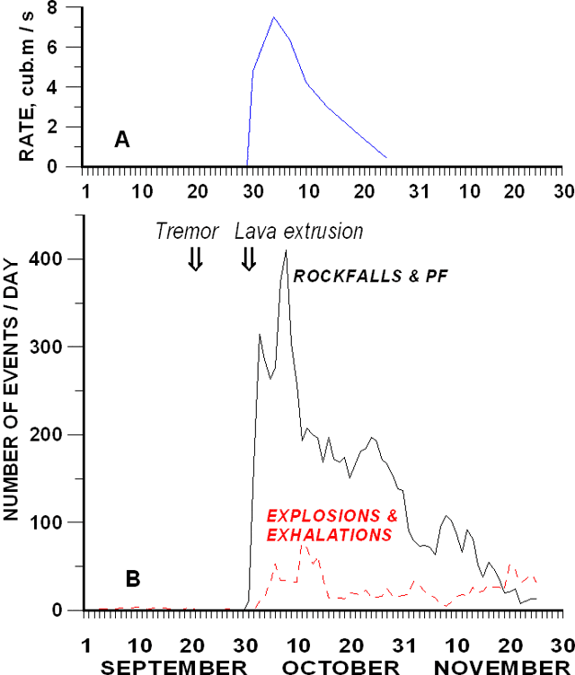
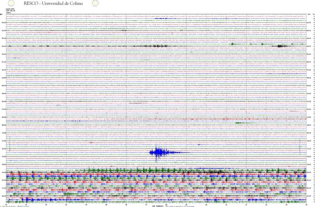
The new lava effusions that began on 30 September took place without either premonitory swarms of volcano-tectonic earthquakes or significant deformation of the volcanic edifice. A 6-hour episode of volcanic tremors was observed on 20 September (figures 72 and 73).
On 28 September, intensive fumarolic activity began in the crater, forming a 500-m-high column of white gas. An overflight that day permitted observation of a new lava extrusion that practically filled the crater. An intensive swarm of seismic events produced by rockfalls and pyroclastic flows began at about 0600 on 30 September. The seismic events indicated the overflow of lava from the crater and heralded the formation of two andesitic block-lava flows. These flows began to develop along Colima's N and WNW slopes.
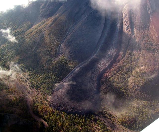
During October and November, lava emission continued at a decreasing rate (figure 72). The lava emissions were effusive and accompanied by frequent small explosions and exhalations. Numerous block-and-ash flows extended ~ 4.5 km from the summit (figure 74). Seismic intensity closely tracked with variations in the lava emission rate.
 |
Figure 74. An oblique aerial photo showing a new lobe of blocky lava emplaced on Colima's N flank. Photo was taken on 27 October 2004. Courtesy of Colima Volcano Observatory. |
By 1 December, the two lava flows stretched ~ 2,400 m long and ~ 300 m wide on the N flanks, and ~ 600 m long and 200 m wide on the WNW flanks (figure 14). The total volume of erupted material including lava and pyroclastic-flow deposits was ~ 8.3 x 10⁶ m3.
Geological Summary. The Colima complex is the most prominent volcanic center of the western Mexican Volcanic Belt. It consists of two southward-younging volcanoes, Nevado de Colima (the high point of the complex) on the north and the historically active Volcán de Colima at the south. A group of late-Pleistocene cinder cones is located on the floor of the Colima graben west and east of the complex. Volcán de Colima (also known as Volcán Fuego) is a youthful stratovolcano constructed within a 5-km-wide scarp, breached to the south, that has been the source of large debris avalanches. Major slope failures have occurred repeatedly from both the Nevado and Colima cones, producing thick debris-avalanche deposits on three sides of the complex. Frequent recorded eruptions date back to the 16th century. Occasional major explosive eruptions have destroyed the summit (most recently in 1913) and left a deep, steep-sided crater that was slowly refilled and then overtopped by lava dome growth.
Information Contacts: Observatorio Vulcanológico de la Universidad de Colima, Colima, Col., 28045, México.


