Report on Colima (Mexico) — March 2005

Bulletin of the Global Volcanism Network, vol. 30, no. 3 (March 2005)
Managing Editor: Richard Wunderman.
Colima (Mexico) Lava flows up to 2.4 km long; March 2005 explosions; collapse on summit
Please cite this report as:
Global Volcanism Program, 2005. Report on Colima (Mexico) (Wunderman, R., ed.). Bulletin of the Global Volcanism Network, 30:3. Smithsonian Institution. https://doi.org/10.5479/si.GVP.BGVN200503-341040
Colima
Mexico
19.514°N, 103.62°W; summit elev. 3850 m
All times are local (unless otherwise noted)
The recent extrusion of block-lava that began on 30 September 2004 continued through November 2004. Lava flows formed on the N and WNW flanks, with the respective dimensions ~ 2,400 m long by ~ 300 m wide, and ~ 600 m long by ~ 200 m wide. The total volume of erupted material, including lava and pyroclastic flows, was about 8.3 x 10⁶ m3 (BGVN 30:01). The termination of lava effusion was followed by intermittent explosive activity represented mainly by small gas-and-ash Vulcanian explosions. Their number gradually decreased during December 2004-March 2005 (figure 75).
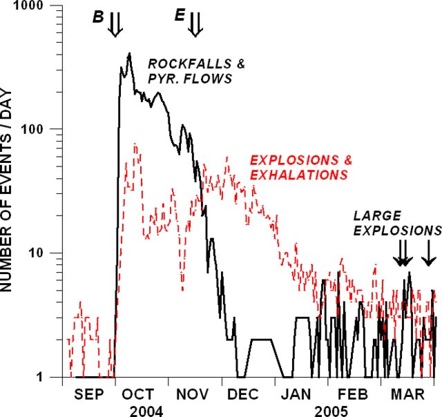 |
Figure 75. Eruptive activity of at Colima during September 2004-March 2005. The variations in the number of earthquakes produced by rockfalls and pyroclastic flows (heavy line) and by explosions and exhalations (dashed line) are shown. Double arrows show the beginning (B) and the end (E) of lava extrusion; three single arrows indicate the explosions of 10, 13, and 26 March. Courtesy of Colima Volcano Observatory. |
Three relatively large explosions occurred in March (on the 10th, the 13th, and the 26th). Those of 10 and 13 March formed eruptive columns with heights of ~ 5 km above the crater and were accompanied by pyroclastic flows down the S flank. The lengths of associated pyroclastic flows did not exceed 2.8 km. The largest explosion to take place on 13 March generated fallout that included lapilli with a diameter of up to 2 cm. Ash fell at a distance of 12.5 km to the NE of the volcano (in the village of Los Mazos, Jalisco).
Scientists made E-W topographic profiles on 12 October 2004 and 18 March 2005 (figure 76). The profiles crossed an area on the summit's S flank. They disclosed that during this intervening interval there had been a collapse over an area of ~ 2,500 m2.
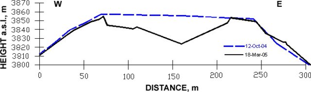 |
Figure 76. Two topographic profiles across the summit of Colima from the S flank made on 12 October 2004 and 18 March 2005. Courtesy of Colima Volcano Observatory. |
Geological Summary. The Colima complex is the most prominent volcanic center of the western Mexican Volcanic Belt. It consists of two southward-younging volcanoes, Nevado de Colima (the high point of the complex) on the north and the historically active Volcán de Colima at the south. A group of late-Pleistocene cinder cones is located on the floor of the Colima graben west and east of the complex. Volcán de Colima (also known as Volcán Fuego) is a youthful stratovolcano constructed within a 5-km-wide scarp, breached to the south, that has been the source of large debris avalanches. Major slope failures have occurred repeatedly from both the Nevado and Colima cones, producing thick debris-avalanche deposits on three sides of the complex. Frequent recorded eruptions date back to the 16th century. Occasional major explosive eruptions have destroyed the summit (most recently in 1913) and left a deep, steep-sided crater that was slowly refilled and then overtopped by lava dome growth.
Information Contacts: Observatorio Vulcanológico de la Universidad de Colima, Colima, Col., 28045, México (URL: https://portal.ucol.mx/cueiv/).