Report on Vailulu'u (United States) — April 2005
Bulletin of the Global Volcanism Network, vol. 30, no. 4 (April 2005)
Managing Editor: Richard Wunderman.
Vailulu'u (United States) ALIA cruise discloses new cone in the summit crater
Please cite this report as:
Global Volcanism Program, 2005. Report on Vailulu'u (United States) (Wunderman, R., ed.). Bulletin of the Global Volcanism Network, 30:4. Smithsonian Institution. https://doi.org/10.5479/si.GVP.BGVN200504-244000
Vailulu'u
United States
14.215°S, 169.058°W; summit elev. -592 m
All times are local (unless otherwise noted)
According to Hubert Staudigel (Scripps Institution of Oceanography) and Stanley Hart (Woods Hole Oceanographic Institute), Vailulu'u seamount, the most active Samoan submarine volcano, erupted between April 2001 and April 2005. It formed a 293-m-tall lava cone, which was named Nafanua after the Samoan Goddess of War. This new cone had been growing inside the 2-km-wide caldera of Vailulu'u at a minimum rate of about 20 cm/day since April 2001. Nafanua was discovered during a 2005 diving expedition with the National Oceanic and Atmospheric Agency (NOAA) research submersible Pisces V, launched from the University of Hawaii research vessel Kaimikai O Kanaloa (KOK). It is located in the originally 1,000-m-deep W crater of Vailulu'u (figures 5 to 8).
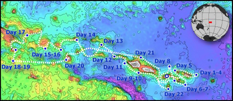 |
Figure 5. The route of the 2005 cruise of the research vessel Kilo Moana. Vailulu'u, towards the E end of the Samoan hotspot trail was visited on cruise days 1-4, 4-8 April 2005. Courtesy of H. Staudigel and S. Hart. |
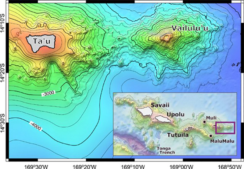 |
Figure 6. Bathymetry of Vailulu'u and nearby Ta'u Island, based on a SeaBeam bathymetric survey performed during R/V Melville's AVON 2 and 3 cruises, augmented with satellite-derived bathymetry from Smith and Sandwell (1996). The inset shows the general location of Vailulu'u with respect to the Samoan Archipelago; two other newly mapped and dredged seamounts (Malumalu and Muli, AVON 3 cruise) are shown as well. Scale: 10' = 18 km. From Hart and others (2000). |
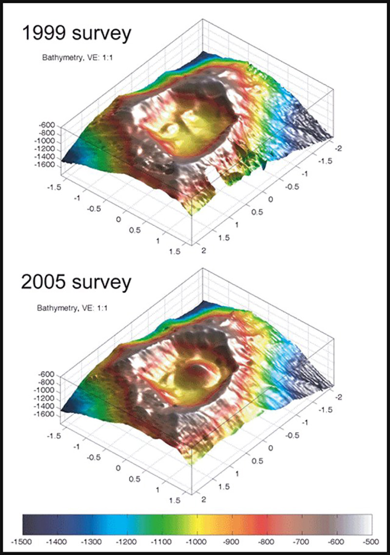 |
Figure 7. Bathymetry of the Vailulu'u crater between the 1999 and 2005 surveys, showing the emergence of Nafanua. Courtesy of H. Staudigel and S. Hart. |
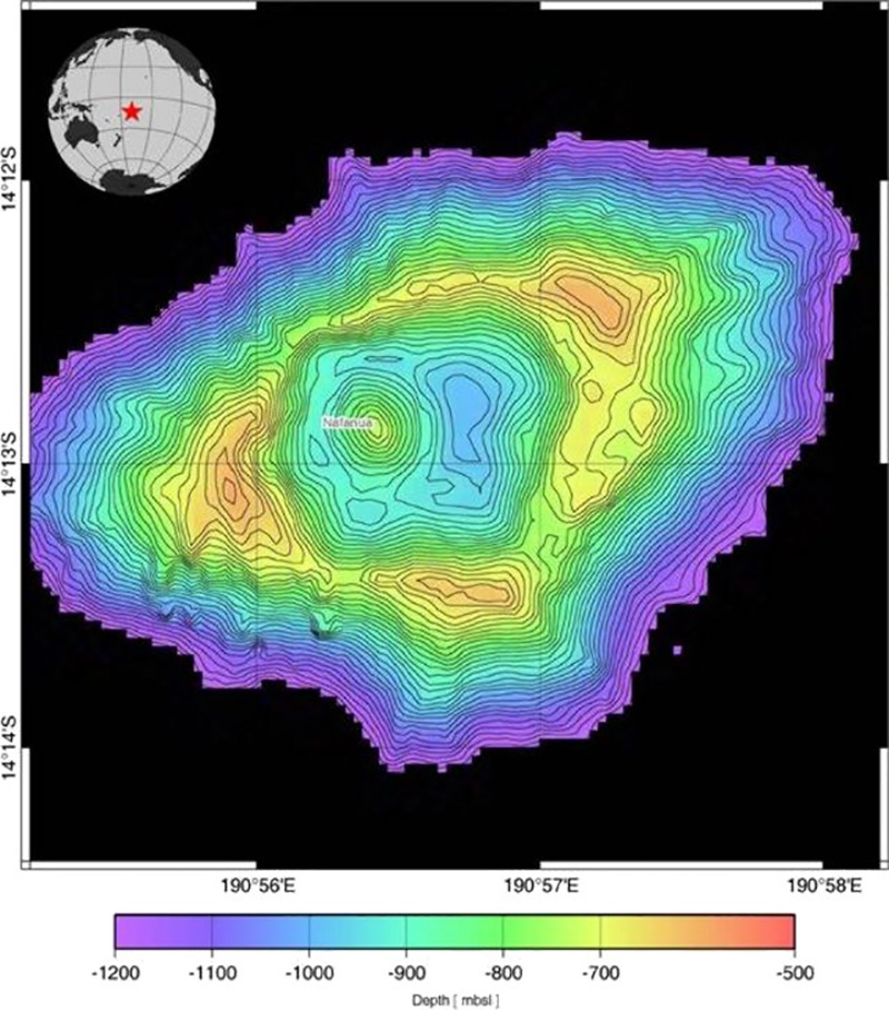 |
Figure 8. Bathymetric map of the Vailulu'u seamount from multibeam data during the April 2005 survey. Note the new inner cone named Nafanua. Contour interval is 20 m. Courtesy of H. Staudigel and S. Hart. |
Seismic monitoring during April-June 2000 showed substantial seismicity, ~ 4 earthquakes per day with hypocenters beneath Nafanua (Konter and others, 2004; BGVN 26:06), which can now be interpreted as pre-eruption seismic activity. These observations are consistent with previous reports highlighting the volcanic and hydrothermal activity of Vailulu'u (Hart and others, 2000; Staudigel and others, 2004). The scientists suggested that continued volcanic activity could bring the summit region of Vailulu'u to a water depth of ~ 200 m. At that point, Nafanua would overtop the crater rim and further growth would require a build-up of the lower flanks, areas that rise from the 5,000-m-deep floor of the ocean.
Staudigel and Hart teamed up in April 2005 on the Hawaiian Research Vessel Kilo Moana to study the Samoan hotspot thought to underlie Vailulu'u. They named their expedition ALIA after the ancient twin-hulled canoe that Samoan warriors used to explore the SW Pacific. The Kilo Moana left Pago Pago on 4 April 2005 to study active and extinct underwater volcanoes along the chain of Samoan islands. The expedition investigated previously uncharted seamounts and the submarine portions of some islands, scattered over almost 600 nautical miles, from its most recent and quite active Vailulu'u submarine volcano in the E to Combe Island in the W.
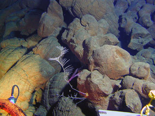
The Nafanua cone was first mapped by using the center beam of the research vessel KOK in several crossings of the W crater. An active hydrothermal system was apparent from evidence such as the murky water that limited visibility during two submersible dives, several microbial biomats covering pillow lavas that were centimeters thick, and a large number of diffuse vents. A dive on 30 March 2005 to examine Nafanua reported "that it must have grown in the last 4 years because CTD (conductivity-temperature-depth) crossings in 2001 still were consistent with the old crater morphology ... the basal portion of the cone displayed relatively large pillows, and higher up pillows look almost like very fluid pahoehoe that collapsed and/or transitioned into aa flows. Nafanua . . . grew very fast with abundant breccia material from collapsing and draining pillows, in particular in the summit region."
On 1 April, another dive along the outer flanks of Vailulu'u found that during the up-slope transit, observers saw a few additional areas of active venting and many sites where there had been venting in the past. Large and perfectly formed pillow lavas were present in most sites, with a few areas being dominated by broken talus fragments and some having completely black glassy pillows with no oxidation, apparent evidence for relatively recent formation. The topography was extremely rough, the slope being punctuated with numerous fissure systems and edifices of pillow lava.
A primary plan for the ALIA expedition was to study the water in and around the seamount for several days using a CTD probe. To sample the inside of the volcano for a full tidal cycle, the scientists varied the depth of the CTD between 40 and 930 m (almost to the crater floor), collecting various data, including visibility. At Vailulu'u, the particulates given off by hydrothermal venting are flushed out of its caldera during each tidal cycle into the surrounding water. In 2005, a dense layer of particulates was found in the water within the crater, but the water was clear outside the crater rim. This contrasts with observations seen from the cruise in 2000, when there was a dense ring of particulates around the whole volcano. It appears that in 2005 the particulates were rising above the crater and then later sinking, instead of forming the widespread ring observed in 2000.
In addition, the expedition crew conducted dredging of the new summit of Nafanua. Staudigel and Hart noted that the rocks from the first dredge haul were quite newly formed, containing pristine olivine-phyric volcanic rocks. Abundant large vesicles in the rocks from Nafanua suggest a volatile-rich magma capable of submarine lava fountaining and explosive outgassing in shallower water. Dredging from a second site, outside of Vailulu'u, recovered rocks that were both much older and far less fragile.
References. Hart, S.R., Staudigel, H., Koppers, A.A.P., Blusztajn, J., Baker, E.T., Workman, R., Jackson, M., Hauri, E., Kurz, M., Sims, K., Fornari, D., Saal, A., and Lyons, S., 2000, Vailulu'u undersea volcano: The new Samoa: Geochemistry, Geophysics, Geosystems (G3), American Geophysical Union, v. 1, no. 12, doi: 10.1029/2000GC000108.
Konter, J.G., Staudigel, H., Hart, S.R., and Shearer, P.M., 2004, Seafloor seismic monitoring of an active submarine volcano: Local seismicity at Vailulu'u Seamount, Samoa: Geochemistry, Geophysics, Geosystems (G3), American Geophysical Union, v. 5, no. 6, QO6007, doi: 10.1029/2004GC000702.
Lippsett, L., 2002, Voyage to Vailulu'u: Searching for Underwater Volcanoes. Woods Hole Oceanographic Institution, Fathom online magazine (URL: http://www.fathom.com/feature/122477/).
Staudigel, H., Hart, S.R., Koppers, A., Constable, C., Workman, R., Kurz, M., and Baker, E.T., 2004, Hydrothermal venting at Vailulu'u Seamount: The smoking end of the Samoan chain: Geochemistry, Geophysics, Geosystems (G3), American Geophysical Union, v. 5, no. 2, QO2003, doi: 10.1029/2003GC000626.
Geological Summary. Vailulu'u, a massive basaltic seamount discovered in 1975, rises 4,200 m from the sea floor to a depth of 590 m. Located about one-third of the way between Ta'u and Rose islands at the E end of the American Samoas, it is considered to mark the current location of the Samoan hotspot. The summit contains an oval-shaped crater that is 2 km wide and 400 m deep. Two principal rift zones extend E and W from the summit, parallel to the trend of the hotspot; a third rift extends SE. The rift zones and escarpments produced by mass wasting phenomena give the seamount a star-shaped pattern. On 10 July 1973 explosions were recorded by SOFAR (hydrophone records of underwater acoustic signals). An earthquake swarm in 1995 may have been related to an eruption. Eruptive activity between April 2001 and April 2005 formed a cone almost 300 m high, named Nafanua. Repeated bathymetric mapping surveys showed depth changes, including height and width increases of Nafanua after 2005, that suggest at least intermittent activity during 1999-2017; a 2019 survey showed no further changes since 2017.
Information Contacts: Hubert Staudigel, Institute of Geophysics and Planetary Physics, Scripps Institution of Oceanography, Univ. of California, San Diego, La Jolla, CA 92093-0225, USA (URL: https://earthref.org/whoswho/ER/hstaudigel/, https://igpp.ucsd.edu/); Stanley R. Hart, Woods Holes Oceanographic Institute, Geology and Geophysics Dept., Woods Hole, MA 02543, USA; ALIA Expedition, Samoan Seamounts, R/V Kilo Moana (KM0506), supported by the San Diego Supercomputer Center and the Scripps Institution of Oceanography (URL: https://earthref.org/ERESE/projects/ALIA/).