Report on Manam (Papua New Guinea) — May 2005

Bulletin of the Global Volcanism Network, vol. 30, no. 5 (May 2005)
Managing Editor: Richard Wunderman.
Manam (Papua New Guinea) Aircraft encounters airborne gas from 27 January 2005 eruption; infrasonics
Please cite this report as:
Global Volcanism Program, 2005. Report on Manam (Papua New Guinea) (Wunderman, R., ed.). Bulletin of the Global Volcanism Network, 30:5. Smithsonian Institution. https://doi.org/10.5479/si.GVP.BGVN200505-251020
Manam
Papua New Guinea
4.08°S, 145.037°E; summit elev. 1807 m
All times are local (unless otherwise noted)
Manam erupted several times during October to December 2004 and January 2005. A strong eruption on 24 October 2004, preceded by a buildup in seismicity and a felt earthquake, was described in BGVN 29:10. This eruption generated pyroclastic flows, and its plume was imaged from space. The eruption sent ash and condensed water in the form of ice to a maximum height of ~ 15 km altitude. On 10-11 November 2004, a Strombolian eruption occurred; the ash column was estimated to have risen ~ 5-6 km above the crater. On 23-24 November 2004 Manam's main crater ejected glowing lava and discharged an ash cloud that rose ~ 10 km high. A lava flow was also reported to be heading for two villages on the island. Details and reports of eruptions in November and December 2004 were included in BGVN 29:11.
The eruption at Manam on the evening of 27 January 2005 (BGVN 30:02) was more severe than the previous ones during the current eruptive period. During 27-28 January 2005 there were 14 people injured and one person killed at Warisi village. The reports of the Rabaul Volcano Observatory (RVO) and the Darwin VAAC, and an analysis of the Manam eruption clouds by Andrew Tupper of the Darwin VAAC, were summarized in BGVN 30:02. In late January, five commercial flights were cancelled from Rabaul, East New Britain, delaying about 100 passengers.
Documented occurrence of olfactory fatigue. A report received from Andrew Tupper discussed an encounter of an aircraft with an airborne gas plume that took place about 2300 UTC on 29 January (0800 on the 30th, East Timor time) reported to him by a pilot. The encounter took place at a considerable distance from Manam, and a map is helpful to visualize the region's geography (figure 21). The incident involved entry into a visibly anomalous, hazy-blue cloud that turned out to contain sulfurous odor (figure 22). Although Tupper and the pilot discussed other possibilities for the cloud's origin, Tupper came to the conclusion that the cloud was volcanic fog (vog) erupted from Manam.
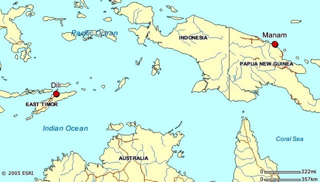 |
Figure 21. The airport at Dili, East Timor (Indonesia), located about 2,200 km WSW of Manam. |
Key portions of the pilot's message conveyed to us by Tupper follow.
"On descent into Dili, approaching 10,000 feet at 12 nautical miles [~ 3 km altitude and ~ 22 km from the airport] aircraft control levers were pulled back to flight idle just prior to entering a thin layer of smooth stratus cloud [figure 22].
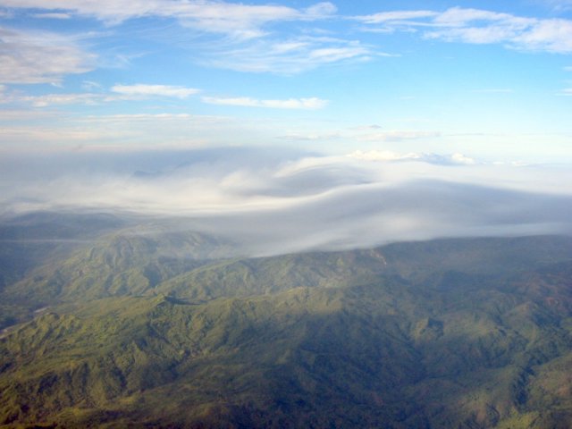 |
Figure 22. The hazy blue cloud that produced a sulfur smell in the cockpit of the plane approaching Dili. The photo was taken by the air crew (names not given). |
"Shortly after passing into the cloud, a strange smell was soon noticed in the cockpit; once the accusations of responsibility had passed, it quickly became apparent that the smell was not the result of a bodily function. The smell became very strong, with high sulfur content. As a precaution the Captain directed the First Officer to don his oxygen mask. The smell persisted but began to weaken on descent, and landing was accomplished without incident. After landing, First Officer removed the oxygen mask and noted the smell had remained. The captain had by this time become desensitized to the smell. Upon shutdown, unloading was halted, until such time as the cargo hold could be examined for a source of the smell. No smell remained."
Tupper and the pilot discussed possible sources for the smell. The cloud displayed a distinct blue haze (Tupper commented that "it's difficult to tell from the attached photo whether the blue is all that out-of-the-ordinary, but obviously they thought it interesting enough to take a photo!"). The cloud sat on the hills and appeared to have fog-like characteristics. The pilot described the odor as sharper and more metallic than the smell of H2S (a description consistent with SO2, the odor of which is sometimes described as metallic or akin to a struck-match.
What caused the sulfurous-smelling stratus cloud? The sulfur content may have come from either nearby volcanoes, none of which have been reported as active, or from industrial production (possibly Kupang). Due to a serious dengue outbreak in East Timor, it may have been the result of chemical mosquito control. Many chemical methods of mosquito control are based on sulfur products. Malathion is one such product; it contains mercaptan, which has a strong noxious odor. (Organic compounds with HS bound to carbon are called mercaptans or thiols and those of low molecular weight have strong smells. Small doses of mercaptan are often used to give natural gas a distinctive odor.) One possible way to explain the sulfurous gases was morning fog moving up the hills of Dili in response to anabatic (upslope-blowing) winds, which also carried residual insecticide.
Tupper spoke to or emailed the pilot several more times to get the following other details. The aircraft was an Embraer E120, a 30 seat turbo prop, with 20-25 people on board. The cabin attendant also noticed the smell, but no passengers commented. Despite the speculation about chemicals above, this was the only trip on which the smells had been noticed by the pilot.
According to Claire Witham, human perception of SO2 odor varies depending on the individual's sensitivity, but SO2 is generally perceived between 0.3-1.4 ppm and is easily noticeable at 3 ppm. This is generally below the level where health effects (e.g. respiratory response) might be noted. In general an exposure limit of 1-5 ppm is the threshold for respiratory response in healthy individuals upon exercise or deep breathing, whilst at 3-5 ppm the gas is easily noticeable and may cause a fall in lung function in persons at rest, and increased airway resistance. Asthmatic individuals may respond at much lower concentrations, and prolonged exposure to low concentrations carries increased risk for those with pre-existing heart and lung diseases. A more detailed review of gas hazards and guidelines has just gone online on the International Volcanic Health Hazard Network.
Significant in this event is that the flight crew thought that the smell had dissipated. The First Officer, who was wearing an oxygen mask, remained able to detect that the smell persisted. This indicates that the others in the crew lost their ability recognize that the sulfurous odors remained, a well-know effect of sulfurous gases called olfactory fatigue ('bombarded nerve receptors'), a potentially confusing situation for pilots focused on escaping from a volcanic plume (Wunderman, 2004).
Tupper conducted dispersion modeling of the 27 January 2005 Manam eruption (figure 23). The results suggested that the SO2 cloud from the volcano probably passed over East Timor on the night before the incident and at higher altitudes. This is supported to a limited extent by the preliminary ozone and SO2 monitoring results (figure 24), which suggest that the bulk of the cloud went N, but that part of the cloud traveled over the Banda Sea and passed over East Timor. The low level winds are highly unlikely to have carried the SO2 to East Timor, but there was significant storm activity on the night when the cloud would have passed over. Excluding other explanations on the grounds that the eruption / encounter timing are unlikely to be mere coincidence, the most likely explanation for the flight crew's experience is that some eruption products from Manam were rained out over East Timor on the night of 29 January 2005. If SO2 had been incorporated into ice particles, which then rained out, the particles would have melted and released SO2 at about the level of the encounter, where the temperature was a bit above freezing. According to this scenario, the plane then flew through the resultant vog/stratus the next morning.
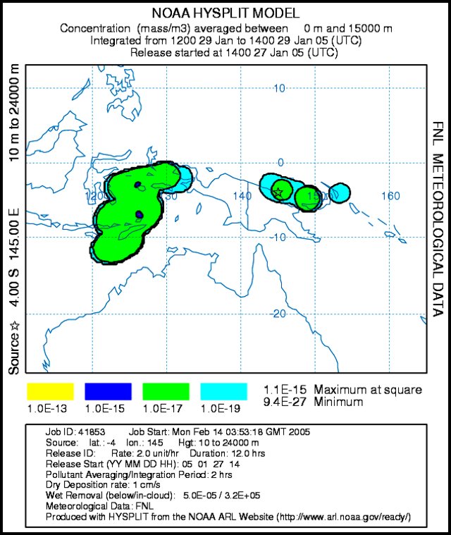 |
Figure 23. An ash dispersion model for the eruption cloud associated with the eruption of Manam on 27 January 2005. The model takes into account wind at various altitudes and other meteorological data, and predicts the movement of material injected in the atmosphere. The model used, NOAA hysplit, adopted the boundary condition that material was above the volcano between 10 and 24 km altitude starting at 1400 on 27 January. The results shown predict the dispersal for the interval 1200-1400 on 29 January. The model indicates that some material from Manam's 27 January eruption traveled WSW to where the aircraft-gas plume encounter took place. The model is a product of the NOAA Air Resources Lab with this particular run provided by Andrew Tupper. |
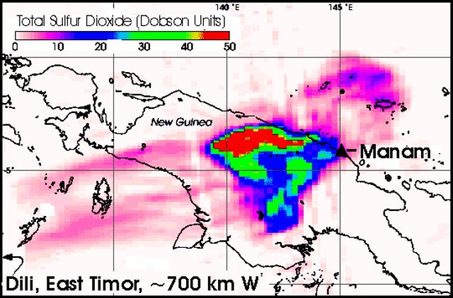 |
Figure 24. A satellite image of atmospheric SO2 burden from Manam made about 12 hours after the 27-28 January 2005 eruption. The image resulted from the NASA Ozone Monitoring Instrument (OMI), which flew over the region on NASA's new Aura satellite. This image was produced from preliminary, uncalibrated data provided by the OMI. The OMI detected a large cloud of SO2 drifting W over the island of New Guinea. The gas is measured in Dobson Units (DU), a reflection of the number of molecules in a square centimeter of the atmosphere. Darker pixels cover the areas of highest concentration, while the lowest concentrations are represented by lighter ones (red and pink, respectively, on the colored electronic version of the Bulletin). If you were to compress all of the SO2 in a column of the atmosphere into a flat layer at standard temperature and pressure, one Dobson Unit would be 0.01 mm (millimeters) thick and would contain 0.0285 grams of SO2 per m2. On January 28, the atmosphere over New Guinea contained up to 50 Dobson Units (red regions), or 1.425 grams of SO2 per square meter. NASA image and caption courtesy Simon Carn, Joint Center for Earth Systems Technology. |
Infrasound reports. The Comprehensive Nuclear Test Ban Treaty Organisation (CTBTO) is installing a world-wide network of 60 infrasound stations as part of the International Monitoring System (IMS) for detection of nuclear tests. The stations, some of which are already functioning, use microbarographs (acoustic pressure sensors) to detect very low-frequency (0.01-10 Hz) sound waves in the atmosphere produced by natural and anthropogenic events.
The eruption at Manam on 27 January at about 1400 UTC was detected at several infrasound stations around the Pacific (table 3). In one case a signal was received at a distance exceeding 10,000 km. The sound of the explosion took more than ten hours to reach that most distant station, located in Washington state (USA). The difference in the calculated and measured signal azimuths is likely caused by high atmosphere winds, and is reasonable given the great distances that the signal traveled.
Table 3. Arrival times and great circle paths for infrasound signal from Manam eruption on 27 January 2005 received at CTBTO infrasound stations. Azimuth and Distance data are for the calculated great circle path from the station to the volcano. Courtesy of Robert North.
| CTBTO Infrasound Station | Azimuth (°E of N) | Distance (km) | Measured signal azimuth (°E of N) | Date | Arrival time |
| I07AU Warramunga, Central Australia | 35 | 2079 | 32 | 27 Jan 2005 | 16:00 UTC |
| I22FR New Caledonia | 311 | 3091 | -- | -- | -- |
| I05AU Tasmania, Australia | 356 | 4270 | 350 | 27 Jan 2005 | 18:30 UTC |
| I55US Windless Bight, Antarctica | 336 | 8303 | 335 | 27 Jan 2005 | 22:07 UTC |
| I53US Fairbanks, Alaska | 247 | 9358 | 252 | 27 Jan 2005 | 23:12 UTC |
| I56US Newport, Washington | 273 | 10920 | 276 | 28 Jan 2005 | 00:34 UTC |
Subsequent RVO observations. Although it remained active, Manam calmed considerably during February-May 2005. During the first two weeks of February 2005, emissions from Manam continued. On 15 February 2005, the alert level was reduced from 3 to 2. Mild eruptive activity was observed from Manam's Southern crater during the third week of February. Weak-to-moderate ash explosions rose a few hundred meters above the crater and drifted E and SE, depositing fine ash in areas downwind. Throughout February, seismicity was at low levels, with small low-frequency earthquakes occurring and no volcanic tremor. Throughout March, weak-to-moderate emissions from both the Main and Southern craters continued to produce occasional ash clouds during most days. On 15 March, a thin plume from Manam was visible on satellite imagery. On 24 March, emissions from Main crater rose to ~ 1 km above the summit. On 28 March, a moderate explosion produced an ash plume to a height of ~ 1.2 km above the summit. Ash plumes drifted N, depositing ash on the island. Seismic activity fluctuated between low and moderate, with low-frequency earthquakes recorded.
During April and May 2005, mild eruptive activity continued at the volcano. Manam remained at alert level 2 from February 2005 through at least late May. A thin plume extending 55 km NW on 4 May was seen on satellite imagery by the Darwin VAAC. The ash cloud remained below 3 km altitude.
Reference. Wunderman, R., 2004, Sulfurous odors: A signal of entry into an ash plume—perhaps less reliable for escape, Second International Conference on Volcanic Ash and Aviation Safety (Alexandria, Virginia, USA), 21-24 June 2004 (Plenary Session 1: Encounters, Damage, and Socioeconomic Consequences, poster P 1.2, Socioeconomic consequences) (http://www.ofcm.gov/ICVAAS/Proceedings2004/ICVAAS2004-Proceedings.htm).
Geological Summary. The 10-km-wide island of Manam, lying 13 km off the northern coast of mainland Papua New Guinea, is one of the country's most active volcanoes. Four large radial valleys extend from the unvegetated summit of the conical basaltic-andesitic stratovolcano to its lower flanks. These valleys channel lava flows and pyroclastic avalanches that have sometimes reached the coast. Five small satellitic centers are located near the island's shoreline on the northern, southern, and western sides. Two summit craters are present; both are active, although most observed eruptions have originated from the southern crater, concentrating eruptive products during much of the past century into the SE valley. Frequent eruptions, typically of mild-to-moderate scale, have been recorded since 1616. Occasional larger eruptions have produced pyroclastic flows and lava flows that reached flat-lying coastal areas and entered the sea, sometimes impacting populated areas.
Information Contacts: Andrew Tupper, Darwin Volcanic Ash Advisory Centre, Australian Bureau of Meteorology (URL: http://www.bom.gov.au/info/vaac); Rabaul Volcano Observatory (RVO), P.O. Box 386, Rabaul, Papua New Guinea; David Innes, Flight Safety Office, Air Niugini, PO Box 7186, Boroko, Port Moresby, National Capital District, Papua New Guinea (URL: http://www.airniugini.com.pg/); International Volcanic Health Hazard Network (URL: http://www.ivhhn.org/); Simon Carn, TOMS Volcanic Emissions Group, Univ. of Maryland, 1000 Hilltop Circle, Baltimore, MD 21250, USA (URL: https://so2.gsfc.nasa.gov/); Claire Witham, Meteorology Office, FitzRoy Road, Exeter, EX1 3PB, UK; Robert North, SAIC Monitoring Systems Division, 1953 Gallows Rd., Vienna, VA 22182, USA; NOAA Air Resources Lab (ARL), Room 3316, 1315 East-West Highway, Silver Spring, MD 20910, USA (URL: http://www.arl.noaa.gov/ready/).