Report on Ambrym (Vanuatu) — May 2005
Bulletin of the Global Volcanism Network, vol. 30, no. 5 (May 2005)
Managing Editor: Richard Wunderman.
Ambrym (Vanuatu) Steady emissions of SO2 create health problems, destroy crops, and contaminate water
Please cite this report as:
Global Volcanism Program, 2005. Report on Ambrym (Vanuatu) (Wunderman, R., ed.). Bulletin of the Global Volcanism Network, 30:5. Smithsonian Institution. https://doi.org/10.5479/si.GVP.BGVN200505-257040
Ambrym
Vanuatu
16.25°S, 168.12°E; summit elev. 1334 m
All times are local (unless otherwise noted)
Jenifer Piatt, a meteorologist with the Air Force Weather Agency in the Satellite Applications Branch, notified Bulletin staff on 17 June 2005 that haze had appeared near Ambrym on MODIS imagery over the past few days. Over the past several months, this volcano had been emitting SO2 and sometimes light ash. She informed us of several recent news articles that addressed this event and provided several satellite images (figure 14).
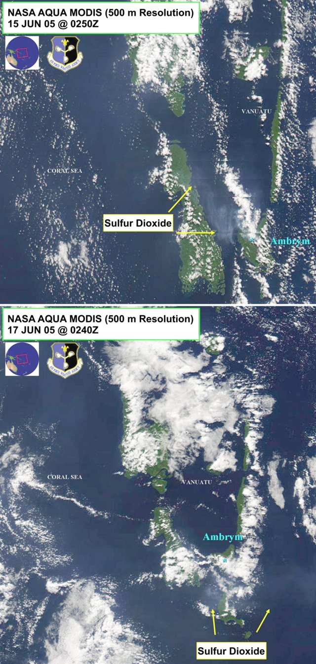 |
Figure 14. Images for 0250 UTC 15 June 2005 (top), and 0240 UTC 17 June 2005 (bottom) disclosing the area around Vanuatu including Ambryn. The images came from NASA's AQUA MODIS satellite with a resolution of 500 m. SO2 plumes from Ambrym are labeled. NASA image courtesy of USAF Weather Agency. |
Tony Ligo wrote on 1 June 2005 in the Port Villa Presse that acid rain continued to fall in W Ambrym Island in Vanuatu, even after ash from the volcano had stopped falling. This prompted the provincial secretary general to discuss the need for new water sources. The Vanuatu government, through the department of Rural Water Supply, agreed to provide a drilling rig to the Malampa provincial government to drill on W Ambrym as soon as possible.
The government also recognized the value of scientific and technical data; in order to effectively respond to such environmental problems the government needs to get more young people studying in this area. The article noted that Vanuatu only has one volcanologist, Charley Douglas, with enough background to give accurate data on current activity.
Aid and food have been sent to affected areas on the western coast of the island, and a contingency evacuation plan is required for resettling people should this be necessary in the future. Health issues have been raised regarding hygiene, respiratory problems, asthma, and malnutrition over the past couple of months. Of great concern are health problems particular to children, including exposure to excess fluoride and the consequent risk of bone disease.
The National Aeronautics and Space Administration (NASA) Earth Observatory web site reported that Ambrym volcano was the strongest point source of SO2 on the planet for the first months of 2005; it had been steadily emitting SO2 for at least 6 months, and satellite images produced using data collected by the Ozone Monitoring Instrument (OMI) on NASA's Aura satellite during the first 10 days of March 2005 show high concentrations of SO2 drifting NW.
The web site article noted that "Ambrym is not erupting in the traditional sense with thick ash plumes and explosive bursts of lava, rather it is leaking SO2 gas from active lava lakes in what scientists call 'passive' or 'non-eruptive' emissions. Despite these gentle names, the volcano still threatens the local population. SO2 has a strong smell and can irritate the eyes and nose and make breathing difficult. Higher in the atmosphere, SO2 combines with water to create rain laced with sulfuric acid. On Ambrym, acid rain has destroyed staple crops and contaminated the water supply, leaving communities in need of food aid." In the past, satellites have been able to monitor SO2 emissions only from large eruptions or the most powerful passive degassing. All other SO2 emissions remain at low altitudes and have low SO2 concentrations that were hard to see from space.
On 15 July 2004, NASA launched its Aura satellite carrying the OMI, which is part of a collaboration between the Netherlands' Agency for Aerospace Programs, the Finnish Meteorological Institute, and NASA. With greater spatial resolution (the ability to "zoom-in" to see greater detail) and higher sensitivity to SO2 than any previous space-borne sensor, OMI allows scientists to study passive volcanic degassing on a daily basis for the first time.
The image in figure 15 is an example of the instrument's preliminary, uncalibrated, and unvalidated data. This new view of passive volcanic emissions could lead to significant advances in understanding both volcanic eruptions and the impact of SO2 on climate. Changes in passive emissions can be a precursor to explosive eruptions, and thus provide a warning signal that activity may be changing.
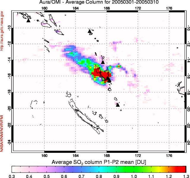 |
Figure 15. A zone of elevated atmospheric SO2 from Ambrym during the interval 1-10 March 2005. The units on the scale bar reflect SO2 in terms of Dobson Units (DU). (A Dobson Unit represents the physical thickness of the SO2 gas if a 1 cm2 column of the atmosphere were brought to 0EC and 1 atmosphere pressure. A value of 300 Dobson Units equals three millimeters.) To process the OMI spectrometer data, two different pairs of measured UV wavelengths are averaged. The mean of pairs 1 and 2 is written as "P1-P2 mean" on the scale bar. Courtesy of Simon Carn. |
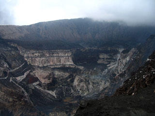
Geological Summary. Ambrym, a large basaltic volcano with a 12-km-wide caldera, is one of the most active volcanoes of the New Hebrides Arc. A thick, almost exclusively pyroclastic sequence, initially dacitic then basaltic, overlies lava flows of a pre-caldera shield volcano. The caldera was formed during a major Plinian eruption with dacitic pyroclastic flows about 1,900 years ago. Post-caldera eruptions, primarily from Marum and Benbow cones, have partially filled the caldera floor and produced lava flows that ponded on the floor or overflowed through gaps in the caldera rim. Post-caldera eruptions have also formed a series of scoria cones and maars along a fissure system oriented ENE-WSW. Eruptions have apparently occurred almost yearly during historical time from cones within the caldera or from flank vents. However, from 1850 to 1950, reporting was mostly limited to extra-caldera eruptions that would have affected local populations.
Information Contacts: Jenifer E. Piatt, HQ Air Force Weather Agency Satellite Applications Branch; Simon Carn, TOMS Volcanic Emissions Group, University of Maryland, 1000 Hilltop Circle, Baltimore, MD 21250, USA (URL: https://so2.gsfc.nasa.gov/); NASA Earth Observatory Natural Hazards web page (URL: http://earthobservatory.nasa.gov/NaturalHazards/).