Report on Colima (Mexico) — June 2005

Bulletin of the Global Volcanism Network, vol. 30, no. 6 (June 2005)
Managing Editor: Richard Wunderman.
Colima (Mexico) Explosions through June 2005, with repeated dome growth and destruction
Please cite this report as:
Global Volcanism Program, 2005. Report on Colima (Mexico) (Wunderman, R., ed.). Bulletin of the Global Volcanism Network, 30:6. Smithsonian Institution. https://doi.org/10.5479/si.GVP.BGVN200506-341040
Colima
Mexico
19.514°N, 103.62°W; summit elev. 3850 m
All times are local (unless otherwise noted)
Small to moderate explosive eruptions have been common at Colima since 1999, some blasting material as high as 11 km altitude and at times sending pyroclastic flows to 5 km runout distances. Between these explosive eruptions, andesitic lava from the main intracrater vent sometimes formed small, short-lived lava domes. The feeder lavas, cryptodomes, and occasional domes were blasted out during subsequent eruptions. A table of significant eruptive events at Colima during July 1999 to June 2005 (Luhr and others, in press) produced this tally for the number of days where plumes went over 2 km above the summit (~6 km altitude): in the latter half of 1999, three days; 2000, one day; 2001, four days; 2002, four days; 2003, 15 days; 2004, ~ 24 days; and in the first half of 2005, 31 days. Eruptions discussed in aviation reports from the Washington Volcanic Ash Advisory Center (VAAC) became a significant source of data starting in 2003, and formed the basis of many entries in the subsequent years.
Extrusions during September-November 2004 formed a new lava dome in the active crater, and two lava flows descended from that crater along the N and WNW flanks (BGVN 30:01). After lava effusion ceased, intermittent explosions and exhalations followed. In the same pattern mentioned above, the dome was later destroyed by Vulcanian-style explosions that produced eruption plumes and in some cases, pyroclastic flows (BGVN 30:03).
The number of seismic events decreased during December 2004-February 2005 (figure 77), and with some important exceptions, remained under 10 events per day until as late as the end of June 2005. During this reporting interval, April-June 2005, intermittent explosions continued (figure 77). Explosions that generated pyroclastic flows were known to have continued through at least 5 July.
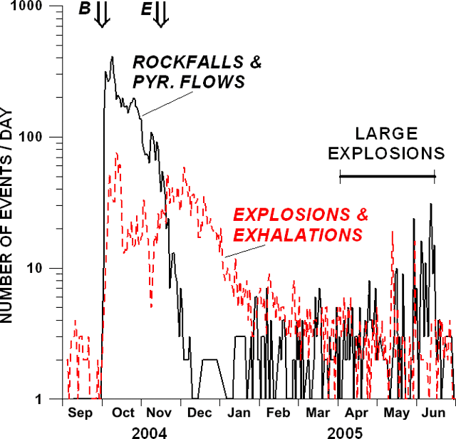 |
Figure 77. The number of daily earthquakes ascribed to rockfalls and pyroclastic flows (heavy line) and to explosions and exhalations (dashed line) at Colima during September 2004-June 2005. Double arrows show the beginning (B) and the end (E) of the lava extrusion in late 2004. A label indicates the period when occasional large explosions took place (an interval that began on 10 March and continued through June 2005). Courtesy of Colima Volcano Observatory. |
Comparatively large explosions began to occur starting 10 March 2005 (BGVN 30:03). The largest, accompanied by pyroclastic flows, were particularly vigorous from 24 May to 5 June. As in March 2004 the explosions consisted of Vulcanian-style gas-and-ash explosions. Some of the April-June explosions issued material that reached as high as ~ 10 km altitude, and pyroclastic flow runout distances reached up to ~ 5.1 km, an increase over those in March 2004 (when maximum runout distances only reached ~ 2.8 km).
When photographed on 25 May 2005 the dome and unconsolidated material filled much of the crater, although the intracrater area was anything but flat (figure 78). By comparison, a photo of the crater taken on 16 June 2005, following many large Vulcanian explosions, shows its upper portion to be essentially empty (figure 79).
 |
Figure 78. At Colima on 25 May 2005 the crater contained considerable dome and unconsolidated material, filling it to near the rim. Several weeks later, after further explosions had driven considerable material out, the upper crater was left with substantial open space (see next photo). Courtesy of Colima Volcano Observatory. |
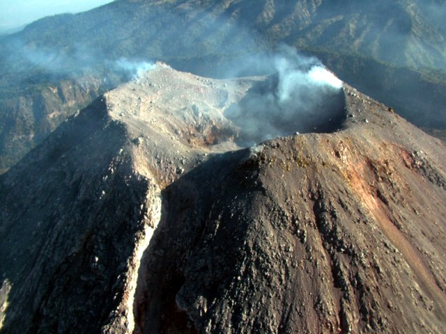 |
Figure 79. Photo of Colima's crater after the comparatively large explosions that began in March 2005. This photo was taken on 16 June looking from the S. Eruptions had removed much of the crater fill and a small dome from the upper crater. Small impact craters pocked the crater floor. An erosion channel had developed across crater's S rim, presumably due to the passage of pyroclastic flows associated with the recent explosions. The notch in the rim has been prominent since 2004 and has emptied and perhaps grown considerably since the photo taken 25 May 2005. Despite the changes seen in this photo, the explosions had left the crater walls intact and without evidence of fractures. Courtesy of Colima Volcano Observatory. |
The March-June explosive sequence removed the 2004 lava dome, and left a crater ~ 260 m across and ~ 30 m deep (figure 79). No significant deformation of the volcanic edifice was recorded before or during the large explosions (table 17). After the explosion of 5 June, residents were evacuated from Juan Barragán, a small village ~ 10 km SE of the summit. Smaller explosions at Colima typically take place at the rate of several per day.
Table 17. Main characteristics of the largest explosions seen at Colima during May-June 2005. Column heights and ash cloud velocities came from remote-sensing data and reports furnished by the Washington VAAC. The highest velocity, 15 m/s, corresponds to 54 km/hour. Courtesy of Colima Volcano Observatory.
| Date | Time (UTC) | Altitude of the column | Direction and average horizontal velocity of plume | Length of plume | Length of pyroclastic flows |
| 24 May 2005 | 0009 | 9.7 km | W (7.7 m/s) | 204 km | 3.5 km |
| 30 May 2005 | 0826 | 8.5 km | SE (15 m/s) | 102 km | 4 km |
| 02 Jun 2005 | 0449 | 6 km | S (5.1 m/s) | 74 km | 4.5 km |
| 05 Jun 2005 | 1920 | 7.6 km | W-SE (7.7 m/s) | 222 km | 5.1 km |
Reference. Luhr, J., Navarro-Ochoa, C., and Savov, I., (in press), Petrology and mineralogy of lava and ash erupted from Volcán Colima, México, during 1999-2005: Special Volume on the Colima Volcano, from the University of Guadalajara (edited by Francisco Nuñez-Cornú).
Geological Summary. The Colima complex is the most prominent volcanic center of the western Mexican Volcanic Belt. It consists of two southward-younging volcanoes, Nevado de Colima (the high point of the complex) on the north and the historically active Volcán de Colima at the south. A group of late-Pleistocene cinder cones is located on the floor of the Colima graben west and east of the complex. Volcán de Colima (also known as Volcán Fuego) is a youthful stratovolcano constructed within a 5-km-wide scarp, breached to the south, that has been the source of large debris avalanches. Major slope failures have occurred repeatedly from both the Nevado and Colima cones, producing thick debris-avalanche deposits on three sides of the complex. Frequent recorded eruptions date back to the 16th century. Occasional major explosive eruptions have destroyed the summit (most recently in 1913) and left a deep, steep-sided crater that was slowly refilled and then overtopped by lava dome growth.
Information Contacts: Observatorio Vulcanológico de la Universidad de Colima, Colima, Col., 28045, México; Washington Volcanic Ash Advisory Center (VAAC), NOAA-NESDES, Satellite Analysis Branch, 5200 Auth Road, Camp Springs, MD 20746, USA.