Report on Heard (Australia) — May 2006
Bulletin of the Global Volcanism Network, vol. 31, no. 5 (May 2006)
Managing Editor: Richard Wunderman.
Heard (Australia) 2006 imagery indicates renewed volcanism
Please cite this report as:
Global Volcanism Program, 2006. Report on Heard (Australia) (Wunderman, R., ed.). Bulletin of the Global Volcanism Network, 31:5. Smithsonian Institution. https://doi.org/10.5479/si.GVP.BGVN200605-234010
Heard
Australia
53.106°S, 73.513°E; summit elev. 2745 m
All times are local (unless otherwise noted)
Matt Patrick observed from MODIS (Moderate Resolution Imaging Spectroradiometer) images analyzed by the HIGP MODVOLC algorithm that relatively new activity began in March 2006 at Heard Island. Two isolated alerts occurred on 11-12 March 2006, and sustained alerts occurred from 7-18 May, 28 May-5 June, and 13-20 June (table 1). Alerts were 1-3 pixels in size. The pixel locations all appeared to be clustered generally near the summit of Big Ben, suggesting central vent (lava lake?) activity rather than lava flows. Advanced Spaceborne Thermal Emission and Reflection Radiometer (ASTER) images over the last several months have all been cloudy and therefore unable to reinforce or support the MODVOLC results. However, a nighttime ASTER image on 29 May 2006 at 0110 showed the new activity (figure 9).
Table 1. MODVOLC alerts for 2006 through 21 June. Courtesy of Hawai'i Institute of Geophysical and Planetology (HIGP) Thermal Alerts Team.
| Date | Time (local) | Pixels | Satellite |
| 11 Mar 2006 | 2315 | 1 | Terra |
| 12 Mar 2006 | 0100 | 2 | Aqua |
| 07 May 2006 | 0100 | 1 | Terra |
| 07 May 2006 | 2305 | 1 | Terra |
| 08 May 2006 | 0150 | 1 | Aqua |
| 09 May 2006 | 2255 | 1 | Terra |
| 10 May 2006 | 0140 | 1 | Aqua |
| 11 May 2006 | 2335 | 1 | Terra |
| 18 May 2006 | 2250 | 2 | Terra |
| 28 May 2006 | 2325 | 1 | Terra |
| 29 May 2006 | 0110 | 2 | Aqua |
| 02 Jun 2006 | 2345 | 3 | Terra |
| 03 Jun 2006 | 0130 | 2 | Aqua |
| 05 Jun 2006 | 0115 | 1 | Aqua |
| 13 Jun 2006 | 2325 | 2 | Terra |
| 14 Jun 2006 | 0110 | 4 | Aqua |
| 15 Jun 2006 | 0010 | 2 | Terra |
| 16 Jun 2006 | 0100 | 1 | Aqua |
| 20 Jun 2006 | 2330 | 1 | Terra |
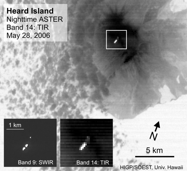 |
Figure 9. ASTER image of Heard Island taken at 0110 on 29 May 2006. The main image is the thermal infrared Band 14 (90 m pixel size), with the inserts showing the shortwave infrared (SWIR Band 9; 30 m pixel size) and thermal infrared (TIR Band 14) closeups. This a nighttime image with no visible bands with 15 m pixel size was difficult to interpret. The N-most segment of the summit anomaly, seen clearly in the Band 9 image, may be the vent, with the remainder of the anomaly possibly representing a ~900-m-long lava flow to the S. Alternatively, the segmentation of the anomaly may reflect different vents. Courtesy Matt Patrick, HIGP Thermal Alert Team. |
The previous phases of activity spanned May 2000-February 2001 and June 2003-June 2004 (BGVN 29:12).
Geological Summary. Heard Island on the Kerguelen Plateau in the southern Indian Ocean consists primarily of the emergent portion of two volcanic structures. The large glacier-covered composite basaltic-to-trachytic cone of Big Ben comprises most of the island, and the smaller Mt. Dixon lies at the NW tip of the island across a narrow isthmus. Little is known about the structure of Big Ben because of its extensive ice cover. The active Mawson Peak forms the island's high point and lies within a 5-6 km wide caldera breached to the SW side of Big Ben. Small satellitic scoria cones are mostly located on the northern coast. Several subglacial eruptions have been reported at this isolated volcano, but observations are infrequent and additional activity may have occurred.
Information Contacts: Matt Patrick, HIGP Thermal Alerts Team, Hawai'i Institute of Geophysics and Planetology (HIGP) / School of Ocean and Earth Science and Technology (SOEST), University of Hawai'i, 2525 Correa Road, Honolulu, HI 96822, USA (URL: http://modis.higp.hawaii.edu/); Andrew Tupper, Darwin Volcanic Ash Advisory Centre, Bureau of Meteorology, Australia.