Report on Mayon (Philippines) — July 2006

Bulletin of the Global Volcanism Network, vol. 31, no. 7 (July 2006)
Managing Editor: Richard Wunderman.
Mayon (Philippines) New eruptive pulse starting 13 July; lava flows; thousands evacuated
Please cite this report as:
Global Volcanism Program, 2006. Report on Mayon (Philippines) (Wunderman, R., ed.). Bulletin of the Global Volcanism Network, 31:7. Smithsonian Institution. https://doi.org/10.5479/si.GVP.BGVN200607-273030
Mayon
Philippines
13.257°N, 123.685°E; summit elev. 2462 m
All times are local (unless otherwise noted)
Mayon was last reported on in March 2006 (BGVN 31:03), discussing an eruption in February 2006. Low-level activity and seismicity prevailed through early July. This report covers an eruptive pulse that began on 13 July 2006 and continued through August 2006. On 13 July there were phreatic eruptions that produced light ashfall in the areas of Calbayog and Malilipot. At 2200 on 14 July, authorities raised the Alert Level from 1 to 3 due to moderate white steam drifting NE and lava flows extending 0.7-1.0 km from the summit onto the SE slopes. On 15 July, the lava flow continued its SE progression towards Bonga gully.
On 16 July, the 6 km radius hazard zone known as the Permanent Danger Zone (PDZ) established around the SE area, was extended to 7 km and during the period covered by this report the radius of the danger zone around the southern sector was extended to 8 km. On 18 July, the Philippine Institute of Volcanology and Seismology (PHIVOLCS) reported that the lava flow had reached 1 km in length and incandescent boulders had rolled 3 km towards the Bonga gully. Seismicity, reported SO2 fluxes, and posted alert levels appear in table 8.
Table 8. Mayon's reported seismicity, SO2 fluxes, and alert levels during 15 July 2006 to 24 August 2006. "?" indicates information not available. Courtesy of PHIVOLCS.
| Date | Volcanic earthquakes | Tremor episodes | SO2 flux (t/d) | Alert Level |
| 15 Jul 2006 | -- | 111 | 2,211 | 3 |
| 17 Jul 2006 | -- | 314 | 1,513 | 3 |
| 18 Jul 2006 | -- | -- | -- | 3 |
| 19 Jul 2006 | -- | 250 | 2,157 | 3 |
| 20 Jul 2006 | -- | -- | -- | -- |
| 21 Jul 2006 | -- | -- | -- | -- |
| 22 Jul 2006 | -- | -- | -- | -- |
| 23 Jul 2006 | -- | -- | -- | -- |
| 24 Jul 2006 | 11 | 324 | 7,020 | 3 |
| 25 Jul 2006 | 12 | 564 | 5,886 | 3 |
| 26 Jul 2006 | 7 | 316 | 9,275 | 3 |
| 27 Jul 2006 | 6 | 421 | 4,550 | 3 |
| 28 Jul 2006 | 8 | 423 | 8,724 | 3 |
| 29 Jul 2006 | 4 | 394 | 6,099 | 3 |
| 31 Jul 2006 | -- | 388 | 12,548 | 3 |
| 01 Aug 2006 | -- | 354 | 7,418 | 3 |
| 02 Aug 2006 | 16 | 450 | 7,050 | 3 |
| 03 Aug 2006 | 51 | 343 | 4,760 | 3 |
| 04 Aug 2006 | 18 | 354 | 2,965 | 3 |
| 05 Aug 2006 | 18 | 354 | 2,965 | 3 |
| 06 Aug 2006 | 12 | 371 | 1,919 | 3 |
| 07 Aug 2006 | -- | -- | -- | -- |
| 08 Aug 2006 | 109 | 344 | 12,745 | 4 |
| 09 Aug 2006 | 21 | 294 | 7,829 | 4 |
| 10 Aug 2006 | 3 | 501 | 6,573 | 4 |
| 11 Aug 2006 | 6 | 213 | 6,876 | 4 |
| 12 Aug 2006 | 6 | 191 | 3,423 | 4 |
| 13 Aug 2006 | 13 | 158 | 5,427 | 4 |
| 14 Aug 2006 | 16 | 152 | 3,493 | 4 |
| 16 Aug 2006 | 15 | 154 | 8,086 | 4 |
| 17 Aug 2006 | 5 | 130 | 2,937 | 4 |
| 18 Aug 2006 | 32 | 307 | 2,937 | 4 |
| 19 Aug 2006 | 22 | 240 | 2,712 | 4 |
| 20 Aug 2006 | 15 | 253 | 6,634 | 4 |
| 21 Aug 2006 | 15 | 274 | 5,390 | 4 |
| 22 Aug 2006 | 24 | 431 | 2,445 | 4 |
| 23 Aug 2006 | 10 | 316 | 5,215 | 4 |
| 24 Aug 2006 | 18 | 451 | 6,328 | 4 |
Pyroclastic flows on the SE slopes prompted approximately 100 families to evacuate on 20 July. On 22 July, lava flows advanced NE towards the Mabinit channel. By 24 July, lava flows had traveled SSE, ~4 km from the summit toward Bonga gully, and branched off to the W and E. Incandescent blocks shed from the toe and margins of the flows traveled SE and were visible at night. Additionally, on 24 July seismographs recorded more than 324 tremor episodes and 11 volcanic earthquakes. SO2 emissions from the summit crater reached 7,000 metric tons per day, several times larger than fluxes reported earlier.
PHIVOLCS reported lava flow advance in terms of straight-line distances, which progressed as follows: 26 July, 4.45 km; 27 July, 4.7 km; and 29 July, 5.4 km. During this time, SO2 rates remained high (table 8), suggesting fresh magma at shallow levels in the volcano. The number of tremor episodes and earthquakes also remained high. Tremor was thought to indicate near-continuous lava blocks detaching from the lava flows. Volcanic earthquakes were thought to reflect ascending magma. Figure 11 shows the lava flow front on 29 July.
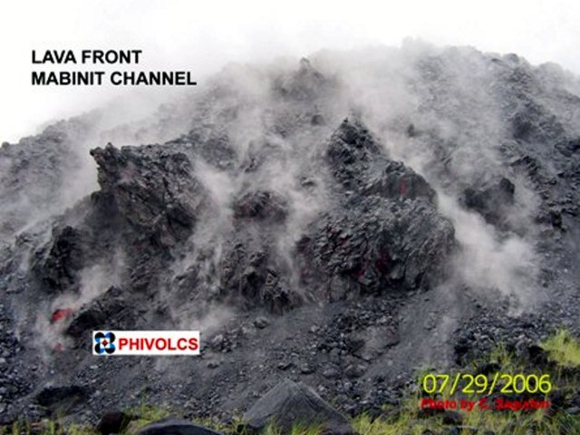 |
Figure 11. Photograph taken on 29 July 2006 at Mayon showing the lava front as it continued to advance down the Mabinit channel. Courtesy of C. Sagution, PHIVOLCS. |
On 29 July, light ash accumulation was reported about 12 km S and SE, in Daraga municipality and Legazpi City and vicinity, respectively. Emissions of sulfur-dioxide reached ~ 12,500 tons per day on 31 July, a record high for this reporting interval. By 1 August, in the SE sector of the Bonga gully, lava flows had advanced ~1.35 km, and in the SSE sector they had advanced a maximum distance of 5.8 km from the summit.
According to a Philippine Information Agency (PIA) press report, military and police checkpoints were set up on 2 August around the 6-km-radius PDZ to prohibit entry. A large lava deposit had grown on the SE flanks. The lava which faced Legazpi and Daraga, had piled up during the initial two weeks of the eruption and threatened to cross the PDZ. PHIVOLCS had reported that the advancing incandescent front of the lava flow was ~20 m high and 50 m wide (figure 12). PHIVOLCS estimated that the lava front could breach the 6-km-radius PDZ within two to three days.
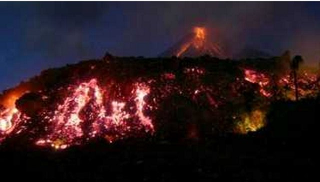 |
Figure 12. On the evening of 3 August 2006, lava advancing down the Mayon's Mabinit channel formed this impressive front. For scale, note tree at right. Although the government had issued an evacuation warning, many tourists flocked to the scene to watch the lava flows. Courtesy of Romeo Ranoco (Reuters). |
An overflight of Mayon on 6 August revealed that lavas discharging from the summit crater extended along the Mabinit channel and spilled into the Bonga gully, E of the Mabinit channel. Due to the decreased supply of lava to the Mabinit channel, the flow there was expected to cease a short distance beyond the 6-km-radius PDZ. Six ash explosions sent ash columns up to 800 m above the summit, prompting PHIVOLCS to raise the alert level from 3 to 4, indicating an eruption is imminent. According to the Manila Bulletin Online, as many as 50,00 people in the Albay province were evacuated.
On 7 August, an advancing lava flow crossed 100 m beyond the 6-km-radius PDZ. According to the Manila Standard Today, authorities warned residents of more lava and fires as the lava flows crept along the Mabinit and Bonga gullies.
During 9-15 August, explosive activity continued at Mayon after a brief respite on 8 August. Based on interpretations of seismic data, minor explosions during 9-11 and 13-15 August were accompanied by lava extrusion and collapsing lava flow fronts that released blocks and small fragments. A drop in SO2 emissions on 9 August worried volcanologists that something had blocked the flow of magma in Mayon's conduit and could therefore cause a build up in pressure resulting in a larger eruption. Visual observations were commonly obscured by clouds. On 11 August an ash plume was seen drifting ESE. On 12 August, four explosions occurred; one produced a pyroclastic flow that traveled over the SE and E slopes and generated a plume that rose to an altitude of 500 m and then drifted NE. On 15 August, a brief break in the clouds allowed for a view and confirmed the presence of fresh pyroclastic deposits from activity in the previous days. Approximately 40,000 people remained in evacuation centers and authorities maintained an Extended Danger Zone at 8 km from the summit in the SE sector.
PHIVOLCS reported that explosions from Mayon continued during 16-19 August. On 17 August, ash-and-steam plumes drifted at least 5.3 km NE and reached the town Calbayog, where light ashfall was reported. Lava extrusion continued and on the SE slopes lava-flow fronts shed blocks and small fragments. On 18 August, the Mibinit and Bonga gully lava flows reached ~ 6.8 km SE from the summit. PHIVOLCS estimated the volume of erupted materials at between 36 and 41 million cubic meters.
Geological Summary. Symmetrical Mayon, which rises above the Albay Gulf NW of Legazpi City, is the most active volcano of the Philippines. The steep upper slopes are capped by a small summit crater. Recorded eruptions since 1616 CE range from Strombolian to basaltic Plinian, with cyclical activity beginning with basaltic eruptions, followed by longer periods of andesitic lava flows. Eruptions occur predominately from the central conduit and have also produced lava flows that travel far down the flanks. Pyroclastic density currents and mudflows have commonly swept down many of the approximately 40 ravines that radiate from the summit and have often damaged populated lowland areas. A violent eruption in 1814 killed more than 1,200 people and devastated several towns.
Information Contacts: Philippine Institute of Volcanology and Seismology (PHIVOLCS), PHIVOLCS Building, C.P. Garcia Avenue, U.P. Campus, Diliman, Quezon City, Philippines, Reuters Alert Network (URL: http://www.alertnet.org/thenews/newsdesk/MAN212904.htm); The Associated Press (URL: http://www.ap.org/); Manila Standard Today (URL: http://manilastandard.net/); Manila Bulletin Online (URL: http://www.mb.com.ph/).