Report on Lopevi (Vanuatu) — February 2007
Bulletin of the Global Volcanism Network, vol. 32, no. 2 (February 2007)
Managing Editor: Richard Wunderman.
Lopevi (Vanuatu) Three eruptive episodes between October 2005 and August 2006
Please cite this report as:
Global Volcanism Program, 2007. Report on Lopevi (Vanuatu) (Wunderman, R., ed.). Bulletin of the Global Volcanism Network, 32:2. Smithsonian Institution. https://doi.org/10.5479/si.GVP.BGVN200702-257050
Lopevi
Vanuatu
16.507°S, 168.346°E; summit elev. 1413 m
All times are local (unless otherwise noted)
Volcanic activity from Lopevi has continued intermittently since November 1998 (BGVN 24:02). Though there are no permanent residents on the island, which is known as Vanei Vollohulu in the local language, the nearby islands of Epi (~ 17 km SW) and Paama (~ 10 km WNW) are heavily populated. Ambrym, another active volcanic island 18 km NNW, is also at risk of ashfall from Lopevi. Ash plumes during active periods are often reported by aviators, and thermal anomalies are frequently detected by the MODIS instrument on the Terra and Aqua satellites. Ash plumes and lava flows have most recently been reported in January, May, and July 2006.
Activity during 2006. Vertical plumes were observed by aviators reaching altitudes of 2.1-2.4 km on the morning of 24 January, and ~ 2.7 km the next morning. Further advisories issued by the Wellington VAAC reported that "smoke" plumes with a "steady rate of growth" rose to ~ 2.1 km on the morning of 26 January and drifted S. Lava flowing down the S flank was also reported on the 26th.
Based on information from a pilot report, the Wellington VAAC reported that on 7 May 2006 a small ash plume was visible below an altitude of ~ 3 km and an active lava flow was observed. On 10 May, a slow moving plume reached 3 km altitude. The next day a plume rose to 4.6 km and trended SE. During 12-13 May, the plume heights lessened to 3 km as the eruption vigor reportedly decreased. News media also reported heavy ashfall on Ambrym and Paama from an eruption on 15 May. An official spokesperson for Vanuatu's National Disaster Management Office reported no new ashfall during 17-22 May.
A situation report from the UN Office for the Coordination of Humanitarian Affairs (OCHA) noted that the May eruptive episode caused heavy ashfall on Paama and SE Ambrym, affecting water supplies and crops. The total population of Paama is 1,572, comprised of 23 villages and 511 households. On the island of Paama, the two main cash crops of vanilla and pepper were damaged badly. On both islands, staple foods such as wild yams, kumala, taros, bananas, and coconut trees were either damaged or destroyed. Residents experienced health problems caused by the consumption of contaminated food and water as well as the inhalation of ash. Head pain, skin infections, diarrhea, vomiting and respiratory difficulties were reported.
The Wellington VAAC received pilot reports of an eruption plume on 5 July that reached an unknown altitude. Another pilot report indicated that the eruption may have started on 27 June. The eruption continued over the next few days, with dark ash plumes reaching altitudes of 3.7 km and drifting E and SE. No plumes were reported after the morning of 10 July.
MODIS thermal anomalies during 2005-2006. Thermal anomalies were detected by MODIS during 26-31 March 2005, though no corresponding explosive activity was reported. No hot spots were identified at Lopevi again until 27 October 2005, after which anomalies were present on most days through 26 January 2006; ash plumes were not reported until the end of this period, 24-26 January.
Later in 2006, thermal anomalies were detected by MODIS on most days during 25-28 April, 2-16 May, 25-28 May, 26 June-9 July, and 18 July-1 August 2006. The largest number of alert pixels (24) during this time occurred at 2225 on 2 May. These data indicated two significant episodes of activity that included both explosive activity and probably lava emission during 25 April-28 May and 26 June-1 August. Two periods of plumes observations discussed previously, during 7-15 May and 27 June-10 July, fall within these longer episodes defined by the thermal data. No MODIS thermal anomalies were detected between 2 August 2006 and mid-March 2007.
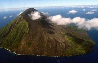
Geological Summary. The small 7-km-wide conical island of Lopevi, known locally as Vanei Vollohulu, is one of Vanuatu's most active volcanoes. A small summit crater containing a cinder cone is breached to the NW and tops an older cone that is rimmed by the remnant of a larger crater. The basaltic-to-andesitic volcano has been active during historical time at both summit and flank vents, primarily along a NW-SE-trending fissure that cuts across the island, producing moderate explosive eruptions and lava flows that reached the coast. Historical eruptions at the 1413-m-high volcano date back to the mid-19th century. The island was evacuated following major eruptions in 1939 and 1960. The latter eruption, from a NW-flank fissure vent, produced a pyroclastic flow that swept to the sea and a lava flow that formed a new peninsula on the western coast.
Information Contacts: Wellington Volcanic Ash Advisory Centre (VAAC), Meteorological Service of New Zealand Ltd (MetService), PO Box 722, Wellington, New Zealand (URL: http://www.metservice.com/vaac/, http://vaac.metservice.com/); MODVOLC Alerts Team, Hawai'i Institute of Geophysics and Planetology (HIGP), SOEST, University of Hawaii and Manoa, 168 East-West Road, Post 602, Honolulu, HI 96822, USA (URL: http://modis.higp.hawaii.edu/); Department of Geology, Mines, and Water Resources, PMB 01, Port-Vila, Vanuatu (URL: http://www.suds-en-ligne.ird.fr/fr/volcan/vanu_eng/lopevi1.htm); Port Vila Presse, PO Box 637, Port Vila, Efate, Vanuatu (URL: http://www.news.vu/en/); ReliefWeb, Office for the Coordination of Humanitarian Affairs, United Nations, New York, NY 10017, USA (URL: https://reliefweb.int/).

