Report on Ruapehu (New Zealand) — March 2007

Bulletin of the Global Volcanism Network, vol. 32, no. 3 (March 2007)
Managing Editor: Richard Wunderman.
Ruapehu (New Zealand) Crater lake tephra dam bursts on 18 March 2007
Please cite this report as:
Global Volcanism Program, 2007. Report on Ruapehu (New Zealand) (Wunderman, R., ed.). Bulletin of the Global Volcanism Network, 32:3. Smithsonian Institution. https://doi.org/10.5479/si.GVP.BGVN200703-241100
Ruapehu
New Zealand
39.28°S, 175.57°E; summit elev. 2797 m
All times are local (unless otherwise noted)
A moderate hydrothermal eruption at Ruapehu on 4 October 2006 (BGVN 32:02) renewed concerns about a lahar that could be generated from breakout of the summit crater lake through a weak dam composed of tephra. The dam, ~ 8 m high, was formed during eruptions in 1995 and 1996. In 1953, a similar dam failed and 15 lives were lost when the resulting lahar destroyed a rail bridge at Tangiwai. As reported by the New Zealand Institute of Geological & Nuclear Sciences (GNS Science), on 18 March 2007 at about 1100 the tephra dam failed and such a lahar was initiated. The resulting discolored region of sediment deposit was visible from space (figure 30).
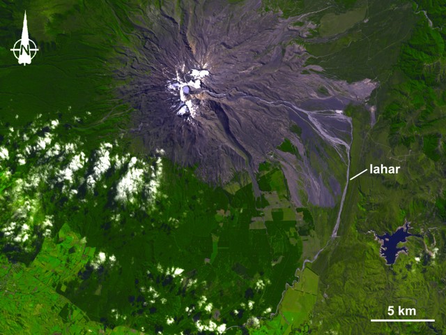 |
Figure 30. The Advanced Spaceborne Thermal Emission and Reflection Radiometer (ASTER) on NASA's Terra satellite captured this image of Mount Ruapehu and the path of its recent lahar on 25 March 2007. In the colored image, green indicates vegetation, dark blue indicates water, and purplish-gray indicates bare rock. The splotches of white at the summit show snow cover, and the billowy white balls nearby are clouds. S of the volcano, straight lines and sharp angles outlining patches of green indicate cultivated crops. The lahar appears as a rivulet of pale grayish-lavender that flows from the summit toward the E, then turns S. Near the base of the volcano, the lahar path separates briefly into two streams. Courtesy of NASA Earth Observatory. |
GNS Science reported that on 18 March 2007 step-wise failure of the dam by headward scarp retreat above seeps in its downstream face was initiated at 1055, followed by catastrophic failure and breaching at 1122. Heavy rain likely played a role in triggering the lahar by raising the surface of Ruapehu's Crater Lake above a critical level. The lake was ~ 1.2 m below the crest of the dam when it failed. A GNS Science fixed camera recorded a time-lapse sequence of images of the dam collapse and the outflow through a 40-m breach in the dam (figure 31). The outflow entered the steep rocky gorge of the upper Whangahu River where it rapidly entrained silt- to boulder-sized particles to become a non-cohesive debris flow within a few kilometers of the lake. The resultant flood (lahar) reached variable stage heights depending on the topography of the 155-km long river system, often exceeding 6-8 m and overtopping the banks. At one point the lahar topped a bridge across the river about 49 km downstream.
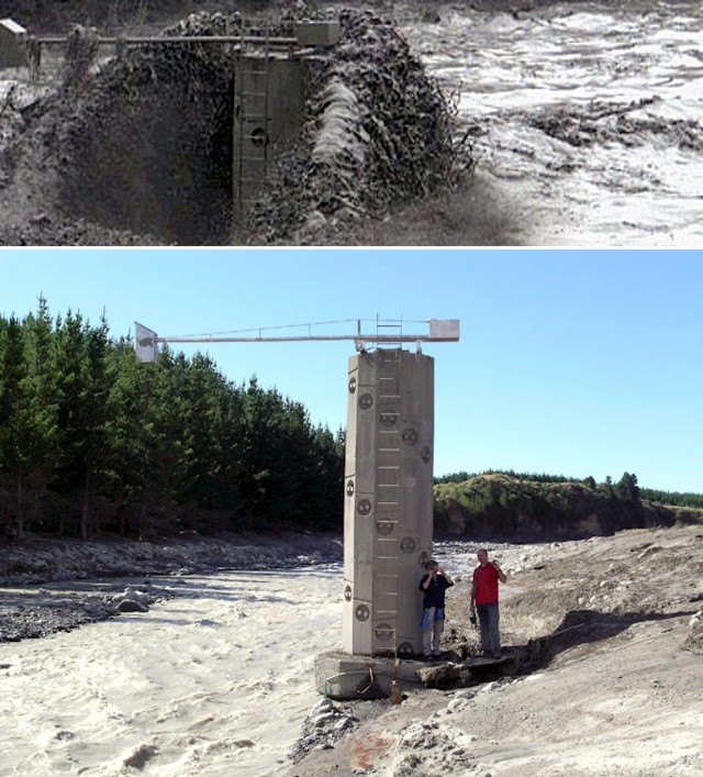 |
Figure 31. Comparative photos of the 6.2-m high OnTrack (New Zealand Railway Corporation) lahar warning tower, located in the Whangaehu river 28 km downstream from Crater Lake. The tower was installed following the 1953 Tangiwai disaster to provide 15-min warning for the railway bridge 11 km downstream. The arm on the tower supports a radar stage gauge to measure flow depth. Images were captured by a Horizon Regional Council web cam. (top) Tower in the path of the lahar flow at 1255 on 18 March 2007. (bottom) Examining lahar deposits on 21 March 2007, with researchers providing scale of the tower and its inscribed scale marks. Courtesy of GNS Science and Vern Manville. |
Lahar chronology. News releases from GNS Science and other agencies were issued on 18 March 2007. Some preliminary derivative reports were sent to us by Roger Matthews. These items provided a chronological series of observations indicating that the dam's failure was initiated at 1045 and climaxed at 1122 on 18 March.
News released at 1203 stated that, prior to the burst, police received indications that the tephra dam confining the Crater Lake was close to overflowing. Alarms from acoustic flow monitors (vibration sensors) installed in the dam at the Crater Lake outlet went off a number of times before the primary dam failure. The three monitoring sites on the crater rim, all activated with the dam failure.
A lahar [called 'moderate' by the New Zealand Department of Conservation (DOC)] was making its way down Mount Ruapehu after Crater Lake dam burst at about 1100 (figure 32). Ruapehu District Council said the lahar was expected to arrive at the Tangiwai road and rail bridges at about 1405 on 18 March. Spokesperson Paul Weetcroft said that the lahar's travel down the Whangaehu River was being monitored, and that the emergency management plan was working well; there were no reports of anyone in danger. He said that at this stage the lahar was expected to travel down the Whangeahu valley and out to sea. Roads were closed in the immediate area and rail transport was stopped. The Minister of Civil Defence, Rick Barker, says the systems set up to warn people about the lahar seem to have worked very well.
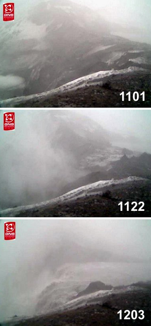 |
Figure 32. A camera installed by GNS Science near the summit of Ruapehu captured the failure of the tephra dam holding back Crater Lake and the lahar's onset. The fixed, digital still camera was installed overlooking the downstream side of the tephra dam in early January 2006. It had been taking pictures at 1-min intervals during daylight. Erosion scarps developed in the downstream face of the dam as a result of seepage through porous tephra layers in early 2007. Growth of these features culminated in dam failure on 18 March 2007. (top) Intact tephra dam at 1101. (middle) Crater Lake waters starting to flood through the breached dam at 1122. (bottom) Crater Lake waters pouring out through the extensive breach in the tephra dam at 1203. Courtesy of GNS Science lahar project, led by Vern Manville. |
The Minister of Conservation stated that the lahar traveled down the predicted path, and the early warning response system worked as planned. An earthen dam (bund, or levee) built to divert the lahar's path toward the S withstood the lahar. As a result, the lahar continued down the Whangaehu valley away from the Tongariro catchment (which drains to the N into Lake Taupo). The lahar also continued safely down the valley and underneath the Tangiwai bridge.
The New Zealand Department of Conservation (DOC) reported at 1545 that the major peak of the lahar had passed. DOC believed the moderate-sized mudflow began when Mt Ruapehu's Crater Lake dam started to collapse between 11 and noon today, releasing the water over a 45-minute period. DOC's Dave Wakelin noted that the water kept within the channels and over the next couple of hours traveled safely down the Whangaehu River and under the Tangiwai bridges. The lahar was almost over by this time (1545), but some material was still moving down the river. No major infrastructure was damaged except for a small DOC footbridge between Tukino Mountain road and Rangipo. The tephra dam which was impounding the new crater lake was fully broken.
Aftermath observations. On 19 March 2007, GNS issued a Science Alert Bulletin concerning increased hydrothermal activity possible at Ruapehu's Crater Lake. Volcanologist Brad Scott of GNS Science said there had been an increase in volcanic earthquakes up to M 1 at the summit following the 18 March partial emptying of Crater Lake. Lowering of the lake could destabilize that hydrothermal system and lead to increased heating and steam-driven eruptions.
Scientists from the Department of Conservation (DOC) and GNS Science visited Mt. Ruapehu's crater lake on 19 March 2007 and confirmed that the tephra dam had eroded back down to the hard rim that formed the pre-1995 lake outlet. Water cascaded across a hard rock rim where once there was a 7.6-m-high dam. Prior to the previous day's collapse, the dam itself was 80-m long. Harry Keys of DOC stated in a press release that the breach was about 50- to 60-m wide at the top and 40-m wide at the hard rock rim, wider than scientists initially thought. The post-lahar lake level was 2,529.4 m elevation, a drop of 6.3 m from the pre-lahar level. The outlet continued to drain and the 'river' was about knee deep. The volume of water lost from the lake was is believed to be in the order of 1.3 x 10⁶ m3. Keys commented further that "One misconception we have heard is that now the lahar has happened there is no longer a Crater Lake! We have now reverted back to pre-1995 conditions with a Crater Lake of about 10x106 m3 that is emptying over its natural outlet on the crater rim into the Whangaehu river." DOC emphasized that conditions either near or on the remains of the tephra dam were unstable and therefore hazardous.
Multi-agency Efforts. The Ruapehu Lahar Emergency Management Plan (Southern) was developed under the leadership of the Ruapehu District Council. Participants included officials from the Southern Ruapehu Lahar Planning Group, New Zealand Department of Conservation, New Zealand Ministry of Civil Defence and Emergency Management, police, and Horizons Regional Council, along with other key agencies including the Army, the New Zealand Fire Service, and GNS Science.
Reference. Keys, H.J.R., (date unknown), Lahars from Mount Ruapehu—mitigation and management; NZ Dept. of Conservation website (a poster conveyed as a PDF file; creation/publication date unknown) (URL: http://www.doc.govt.nz/templates/summary.aspx?id=42442).
Geological Summary. Ruapehu, one of New Zealand's most active volcanoes, is a complex stratovolcano constructed during at least four cone-building episodes dating back to about 200,000 years ago. The dominantly andesitic 110 km3 volcanic massif is elongated in a NNE-SSW direction and surrounded by another 100 km3 ring plain of volcaniclastic debris, including the NW-flank Murimoto debris-avalanche deposit. A series of subplinian eruptions took place between about 22,600 and 10,000 years ago, but pyroclastic flows have been infrequent. The broad summait area and flank contain at least six vents active during the Holocene. Frequent mild-to-moderate explosive eruptions have been recorded from the Te Wai a-Moe (Crater Lake) vent, and tephra characteristics suggest that the crater lake may have formed as recently as 3,000 years ago. Lahars resulting from phreatic eruptions at the summit crater lake are a hazard to a ski area on the upper flanks and lower river valleys.
Information Contacts: Institute of Geological & Nuclear Sciences (GNS), Private Bag 2000, Wairakei, New Zealand (URL: http://www.gns.cri.nz/, https://www.geonet.org.nz/); Brad Scott, Institute of Geological & Nuclear Sciences (GNS); New Zealand Department of Conservation, Private Bag, Turangi, New Zealand (URL: http://www.doc.govt.nz/); Roger Matthews, North Shore City Council, Private Bag 93500 Takapuna, North Shore City 1331, New Zealand (URL: http://www.northshorecity.govt.nz); The Press (URL: http://www.stuff.co.nz/thepress); National Aeronautics and Space Administration (NASA), Earth Observatory (URL: http://earthobservatory.nasa.gov/).