Report on Ritter Island (Papua New Guinea) — March 2007
Bulletin of the Global Volcanism Network, vol. 32, no. 3 (March 2007)
Managing Editor: Richard Wunderman.
Ritter Island (Papua New Guinea) Small eruptions, in 2002 and another in October 2006
Please cite this report as:
Global Volcanism Program, 2007. Report on Ritter Island (Papua New Guinea) (Wunderman, R., ed.). Bulletin of the Global Volcanism Network, 32:3. Smithsonian Institution. https://doi.org/10.5479/si.GVP.BGVN200703-251070
Ritter Island
Papua New Guinea
5.519°S, 148.115°E; summit elev. 75 m
All times are local (unless otherwise noted)
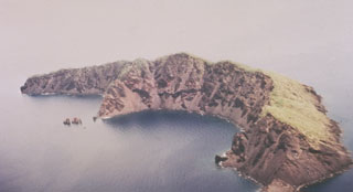
Submarine eruptions occurred at Ritter Island in 1972 and 1974 (CSLP Card 1973). More recently, small eruptions were reported during 2002 and 2006. The island, which sits off the W end of New Britain Island (figure 1), is composed of a ~ 1.9-km-long arc-shaped segment of the caldera rim. The inner, concave side of the island faces W. In clear weather villagers in Kampalap village, ~ 13.5 km SSW on Umboi Island, can see and monitor Ritter Island.
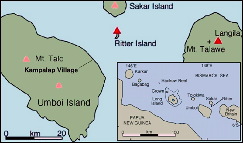 |
Figure 1. Location sketch maps showing the context of Ritter Island, which sits just E of New Britain Island and N of the main island. Many of the islands shown contain Holocene volcanoes along the same arc as New Britain Island. Courtesy of VolcanoWorld. |
On 2 August 2002, an advisory was issued by the Darwin VAAC based on a pilot observation indicating an ash cloud to ~ 3 km altitude, although satellite data was unable to confirm the presence of ash.
In what began as an ambiguous case, the Darwin VAAC issued an advisory for a 17 October 2006 eruption at Ritter Island. The initial report was confusing because a pilot had reported the eruption to the Rabaul Volcano Observatory (RVO) as being from Langila. The VAAC report noted that there was no plume at Langila in satellite imagery, but instead could see one farther W at Ritter Island. The plume was low and seen on MTSAT imagery (at 0133 UTC on 17 October); the presence of ash was not mentioned.
A report to RVO from Kampalap village, passed through the Langila observer, confirmed unusual activity on 17 October. RVO reported occasional small earthquakes followed by white vapor and diffuse ash clouds. The Kampalap observer saw occasional rock slides from the inner crater wall. Fine ash fell at Kampalap that the reporter indicated was not from Langila. No similar eruptive episodes were recorded through 1 November. Throughout this interval the RVO relied on seismic instrumentation in West New Britain, but an instrument was being prepared for possible deployment at Ritter Island.
Geological Summary. Prior to 1888, Ritter Island was a steep-sided, nearly circular island about 780 m high between Umboi and Sakar Islands. Several historical explosive eruptions had been recorded prior to 1888, when large-scale slope failure destroyed the summit of the conical basaltic-andesitic volcano, leaving the arcuate 140-m-high island with a steep west-facing scarp. Devastating tsunamis were produced by the collapse and swept the coast of Papua New Guinea and offshore islands. Two minor post-collapse explosive eruptions, during 1972 and 1974, occurred offshore within the largely submarine 3.5 x 4.5 km breached depression formed by the collapse.
Information Contacts: Herman Patia, Rabaul Volcanological Observatory (RVO), Department of Mining, Private Mail Bag, Port Moresby Post Office, National Capitol District, Papua New Guinea; VolcanoWorld (URL: http://volcano.oregonstate.edu/).