Report on Raoul Island (New Zealand) — April 2007
Bulletin of the Global Volcanism Network, vol. 32, no. 4 (April 2007)
Managing Editor: Richard Wunderman.
Raoul Island (New Zealand) Update on March 2006 eruption; new submarine volcanoes discovered
Please cite this report as:
Global Volcanism Program, 2007. Report on Raoul Island (New Zealand) (Wunderman, R., ed.). Bulletin of the Global Volcanism Network, 32:4. Smithsonian Institution. https://doi.org/10.5479/si.GVP.BGVN200704-242030
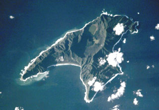
Raoul Island
New Zealand
29.27°S, 177.92°W; summit elev. 516 m
All times are local (unless otherwise noted)
This report discusses evidence for the end of the March 2006 eruption, and press releases announcing newly acquired multibeam bathymetry that disclosed submarine calderas on the flanks of Raoul Island and some adjacent volcanoes.
End of the March 2006 eruption. After the 17 March 2006 eruption (BGVN 31:03), volcanic activity decreased significantly. On 18 September 2006 the Alert Level was lowered to 0.
GeoNet Science (GNS) summarized the decreased activity in their Volcano Alert Bulletin of 18 September 2006. The report noted an absence of significant earthquakes within ~ 30 km of Raoul Island. The water level in Green Lake had continued to drop and was close to the pre-eruption level by 18 September. On 27 August the lake temperature was 20.3°C, well within the seasonal range. The level of ongoing hydrothermal activity (upwelling in Green Lake, nearby hot pools, and steaming ground) was commensurate with that expected six months after an eruption like that seen in March. Chemical analyses of samples recently collected from some of the thermal features were typical of volcano-hydrothermal features in this environment.
GNS reported that the water level in Green Lake, which had risen significantly during the week after the March 2006 eruption and had drowned several new steam vents, still remained above pre-eruption levels as of July 2006, but thereafter dropped slowly. Upwelling and bubbling of springs indicated the volcanic-hydrothermal system was still weakly active 3 months after the eruption. The water temperature, obtained from a thermal infrared satellite image taken on 11 April 2006, was 39.2°C, was 7°C above the average water temperature in April, but had returned to seasonal temperatures by August 2006.
Only 1 to 5 earthquakes were recorded per day in the months following the eruption. The number of earthquakes 30-40 km offshore was slightly higher than normal.
New submarine volcanoes discovered. Marine geologists who had investigated two volcanoes in the Kermadec Arc during May 2007, discovered two new submarine volcanoes near Raoul Island. The geologists were on a scientific expedition mounted by New Zealand's National Institute of Water & Atmospheric Research (NIWA) and the University of Auckland aboard NIWA's deepwater research vessel Tangaroa. They investigated volcanoes on the two largest Kermadec Islands (Raoul and Macauley) and their submerged flanks.
A 22 May 2007 press release by NIWA reported that new seafloor observations revealed for the first time the presence of two submerged calderas. Both calderas were relatively small, ~ 4 km in diameter. One caldera was very deep, measuring ~ 1 km from the rim to the crater floor. Both volcanoes appeared geologically young, on the order of thousands of years old, but laboratory analysis of sediments will be needed to better quantify their age.
The expedition took sediment samples and mapped the contours of the volcanoes both above and below sea level (the latter using multibeam sonar). A series of sediment cores taken from E and W of both islands revealed at least six eruptions from the two islands, recorded as centimeter-thick layers up to 100 km from the islands.
Geological Summary. Anvil-shaped Raoul Island is the largest and northernmost of the Kermadec Islands. During the past several thousand years volcanism has been dominated by dacitic explosive eruptions. Two Holocene calderas exist, the older of which cuts the center the island and is about 2.5 x 3.5 km wide. Denham caldera, formed during a major dacitic explosive eruption about 2200 years ago, truncated the W side of the island and is 6.5 x 4 km wide. Its long axis is parallel to the tectonic fabric of the Havre Trough that lies W of the volcanic arc. Historical eruptions during the 19th and 20th centuries have sometimes occurred simultaneously from both calderas, and have consisted of small-to-moderate phreatic eruptions, some of which formed ephemeral islands in Denham caldera. An unnamed submarine cone, one of several located along a fissure on the lower NNE flank, has also erupted during historical time, and satellitic vents are concentrated along two parallel NNE-trending lineaments.
Information Contacts: Steve Sherburn, GeoNet Science (GNS), Wairakei Research Centre, Private Bag 2000, Taupo, New Zealand; Ian Wright, Ocean Geology group, National Institute of Water & Atmospheric Research (NIWA), PO Box 14901, Wellington, New Zealand (URL: http://www.niwascience.co.nz); Roger Matthews, North Shore City Council, 1 The Strand, Takapuna Private Bag 93500, Takapuna, North Shore City, New Zealand (URL: http://www.northshorecity.govt.nz/).