Report on Lopevi (Vanuatu) — May 2007

Bulletin of the Global Volcanism Network, vol. 32, no. 5 (May 2007)
Managing Editor: Edward Venzke.
Lopevi (Vanuatu) New eruptive episode with ash plumes and thermal anomalies during April-May
Please cite this report as:
Global Volcanism Program, 2007. Report on Lopevi (Vanuatu) (Venzke, E., ed.). Bulletin of the Global Volcanism Network, 32:5. Smithsonian Institution. https://doi.org/10.5479/si.GVP.BGVN200705-257050
Lopevi
Vanuatu
16.507°S, 168.346°E; summit elev. 1413 m
All times are local (unless otherwise noted)
No eruptive activity was evident from Lopevi following the June-July 2006 episode (BGVN 32:02) until 21 April 2007. Between 21 April and 14 May 2007 thermal anomalies detected by satellites again became an almost daily event. This was the fourth eruptive episode since October 2005 (table 2). No anomalies were observed after 14 May through 26 June 2007.
Table 2. Summary of MODIS thermal anomaly measurements at Lopevi from 27 October 2005 to 26 June 2007. "Nearly daily anomalies" indicate gaps in measurements of no more than 3-4 days, unless otherwise noted; these may be due to obscuring cloud cover. Courtesy of Hawai'i Institute of Geophysics and Planetology (HIGP) Thermal Alert System.
| Period | Observations |
| 27 Oct 2005-25 Jan 2006 | Nearly daily anomalies except for two 8-day and two 7-day periods; 1-4 pixels per satellite measurement (8 pixels on 21 December). |
| 26 Jan 2006-24 Apr 2006 | No thermal anomalies measured for about 90 days. |
| 25 Apr 2006-28 May 2006 | Nearly daily anomalies except for one 7-day period; 1-5 pixels per satellite measurement (12 pixels on 13 May, 23 pixels on 2 May). |
| 29 May 2006-25 Jun 2006 | No thermal anomalies measured for about 28 days. |
| 26 Jun 2006-31 Jul 2006 | Nearly daily anomalies except for one 7-day period; 1-7 pixels per satellite measurement (11 pixels on 28 June, 10 pixels on 7 July). |
| 01 Aug 2006-20 Apr 2007 | No thermal anomalies measured for about 260 days. |
| 21 Apr 2007-14 May 2007 | Nearly daily anomalies; 1-7 pixels per satellite measurement (9 pixels on 22 April, 11 pixels on 23 April, 10 pixels on 24 April, 11 Pixels on 26 April, 10 pixels on 28 April, and 9 pixels on 31 April). |
| 15 May 2007-26 Jun 2007 | No thermal anomalies measured for about 40 days. |
Based on pilot reports and satellite imagery, the Wellington VAAC reported that ash plumes rose to altitudes of 2.4-4.6 km during 21-24 April 2007. The plume on the 22nd was described as being a very dense dark gray ash plume with a steady growth rate. On 25 April a pilot reported that an ash plume covered the vent. A light brown eruption cloud over the island that drifted E from Lopevi on 3-4 May was detected by the Moderate Resolution Imaging Spectroradiometer (MODIS) on NASA's Aqua satellite (figure 23). The gray-brown plume became more diffuse downwind, with a pale gray plume spreading SE and N. Aviation notices from the Wellington VAAC noted that wind models indicated light easterly winds below 3 km, tending northerly above 1.8 km altitude. A pilot reported that the plume rose to 2.1 km altitude. The U.S. Air Force Weather Agency reported an extensive area of vog (volcanic smog) resulting from the eruption.
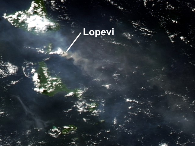 |
Figure 23. Satellite image of an ash plume from Lopevi, 3 May 2007. The plume appears as a small, mostly opaque gray-beige puff. The area of vog, which appears as a more transparent, dingy-gray haze, dwarfs the diminutive plume. Courtesy of NASA Earth Observatory. |
Geological Summary. The small 7-km-wide conical island of Lopevi, known locally as Vanei Vollohulu, is one of Vanuatu's most active volcanoes. A small summit crater containing a cinder cone is breached to the NW and tops an older cone that is rimmed by the remnant of a larger crater. The basaltic-to-andesitic volcano has been active during historical time at both summit and flank vents, primarily along a NW-SE-trending fissure that cuts across the island, producing moderate explosive eruptions and lava flows that reached the coast. Historical eruptions at the 1413-m-high volcano date back to the mid-19th century. The island was evacuated following major eruptions in 1939 and 1960. The latter eruption, from a NW-flank fissure vent, produced a pyroclastic flow that swept to the sea and a lava flow that formed a new peninsula on the western coast.
Information Contacts: NASA Earth Observatory (URL: http://earthobservatory.nasa.gov/); Hawai'i Institute of Geophysics and Planetology (HIGP) Thermal Alerts System, School of Ocean and Earth Science and Technology (SOEST), Univ. of Hawai'i, 2525 Correa Road, Honolulu, HI 96822, USA (URL: http://modis.higp.hawaii.edu/); Wellington Volcanic Ash Advisory Centre (VAAC), Meteorological Service of New Zealand Ltd (MetService), PO Box 722, Wellington, New Zealand (URL: http://vaac.metservice.com/).