Report on Ruapehu (New Zealand) — June 2007

Bulletin of the Global Volcanism Network, vol. 32, no. 6 (June 2007)
Managing Editor: Richard Wunderman.
Ruapehu (New Zealand) Follow up on the 18 March 2007 lake burst and lahar
Please cite this report as:
Global Volcanism Program, 2007. Report on Ruapehu (New Zealand) (Wunderman, R., ed.). Bulletin of the Global Volcanism Network, 32:6. Smithsonian Institution. https://doi.org/10.5479/si.GVP.BGVN200706-241100
Ruapehu
New Zealand
39.28°S, 175.57°E; summit elev. 2797 m
All times are local (unless otherwise noted)
This material supplements our most recent Bulletin report on Ruapehu (BGVN 32:03). There we indicated that the tephra dam at Crater lake burst on 18 March 2007, initiating a lahar. Only a portion of the lake drained, a body that contains ~ 9 x 10⁶ m3 of hot acidic water at 2,530 m elevation (Manville and others, 2007). Recent pictures taken before and after the event show a portion of the lahar channel (figures 33 and 34). This lahar was among the best studied and carefully instrumented to date and may shed light on how volcano dams fail. Vernon Manville coordinated the science response to the lahar and noted that the large boulder that serves as a scale in figures 33 and 34 is "a large chunk of older (probably pre-glacial) lahar deposits. Its long axis is about 10 m, which would give 10-15 m of aggradation in the channel as a result of the 2007 lahar."
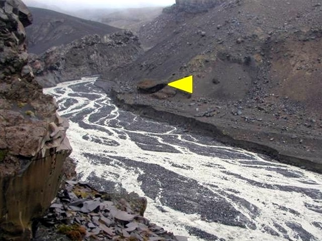 |
Figure 33. Ruapehu's lahar channel just before the collapse of Crater Lake's walls on 18 March 2007. Point of triangle indicates a large boulder to the right of the river channel; it's long axis is ~ 10 m in length. Courtesy of Vern Manville and Rebecca Carey, and the U.S. National Science Foundation. |
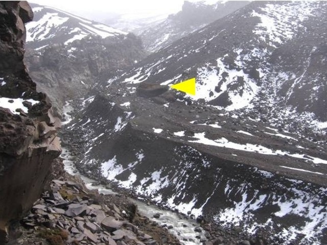 |
Figure 34. Ruapehu's lahar channel just after the collapse of Crater Lake's walls on 18 March 2007. Point of triangle indicates the same boulder as in the previous figure. Courtesy of Vern Manville, Sarah Fagents, and the U.S. National Science Foundation. |
An article in Science (Bohannon, 2007) described the technology used by the New Zealand Department of Conservation to warn of an impending lahar and to predict its path. Prior to the failure, direct current (dc) resistivity surveys were made across the tephra dam in 2005, 2006, and 2007 (Turner and others, 2007). Investigators found the dam's electrical conductivity, which is sensitive to the degree of water saturation, dropped as the lake water level rose and water infiltrated into the tephra dam. The January 2007 measurement found a large increase in conductivity, suggesting that the dam had become close to saturated.
The early warning system included geophones at the lake's rim and on the slopes, a buried wire set to trip when the dam burst, and a meter in the lake to record sudden drops in the lake level. On 18 March, the instruments recorded a breach in the tephra dam and the resulting lahar, which generated an alarm message transmitted automatically to scientists, police, and highway authorities. No one was injured and damage was minor, even though the lahar traveled 155 km to the ocean. According to the article, data indicated that the surging lahar may have produced a soliton, a standing wave that is able to propagate over great distances without losing energy or changing shape.
The Science article also indicated that researchers are developing "before" and "after" landscape images to gain insight into possible future lahar routes. To accomplish this, researchers have collected samples and used Global Positioning System measurements and light detection and ranging (LIDAR) technology to map the composition and distribution of material on the slopes and to develop three-dimensional models of land features.
According to a US National Science Foundation press release (NSF, 2007), a University of Hawaii volcanologist, Sarah Fagents, is using the data from Ruapehu to develop a computer model to simulate the route a future lahar would take and to predict the associated hazards. The model would eventually consider different lahar triggering mechanisms, and incorporate allowances for different locations, to make it widely applicable.
References. Bohannon, J., 2007, Geophysics—Stalking a volcanic torrent: Science v. 316, p. 1562-1563, 15 June 2007 (URL: http://www.sciencemag.org/).
Manville, V.R., Hodgson, K.A., and Nairn, I.A., 2007, A review of break-out floods from volcanogenic lakes in New Zealand: New Zealand Journal of Geology and Geophysics, v. 50, no. 2, p. 131-150.
National Science Foundation, 2007, Geologists Witness Unique Volcanic Mudflow in Action in New Zealand, 13 July 2007: NSF press release 07-077.
Turner, G., Ingham, M., and Bibby, H., 2007, Electrical resistivity monitoring of seepage and stability of the tephra barrier at Crater Lake, Mt Ruapehu, New Zealand: Geophysical Research Abstracts, v. 9, p. 11630.
Geological Summary. Ruapehu, one of New Zealand's most active volcanoes, is a complex stratovolcano constructed during at least four cone-building episodes dating back to about 200,000 years ago. The dominantly andesitic 110 km3 volcanic massif is elongated in a NNE-SSW direction and surrounded by another 100 km3 ring plain of volcaniclastic debris, including the NW-flank Murimoto debris-avalanche deposit. A series of subplinian eruptions took place between about 22,600 and 10,000 years ago, but pyroclastic flows have been infrequent. The broad summait area and flank contain at least six vents active during the Holocene. Frequent mild-to-moderate explosive eruptions have been recorded from the Te Wai a-Moe (Crater Lake) vent, and tephra characteristics suggest that the crater lake may have formed as recently as 3,000 years ago. Lahars resulting from phreatic eruptions at the summit crater lake are a hazard to a ski area on the upper flanks and lower river valleys.
Information Contacts: Vern Manville, Institute of Geological & Nuclear Sciences (GNS), Wairakei Research Centre, Private Bag 2000, Taupo 2730, New Zealand; Sarah Fagents and Rebecca Carey, School of Ocean and Earth Science and Technology (SOEST), University of Hawaii at Manoa; National Science Foundation, 4201 Wilson Boulevard, Arlington, VA 22230, USA (URL: https://www.nsf.gov/news/news_summ.jsp?cntn_id=109702).