Report on Batu Tara (Indonesia) — December 2007
Bulletin of the Global Volcanism Network, vol. 32, no. 12 (December 2007)
Managing Editor: Richard Wunderman.
Batu Tara (Indonesia) Thermal anomalies beginning January 2007; ash plumes during March-October
Please cite this report as:
Global Volcanism Program, 2007. Report on Batu Tara (Indonesia) (Wunderman, R., ed.). Bulletin of the Global Volcanism Network, 32:12. Smithsonian Institution. https://doi.org/10.5479/si.GVP.BGVN200712-264260
Batu Tara
Indonesia
7.791°S, 123.585°E; summit elev. 633 m
All times are local (unless otherwise noted)
On 1 July 2006 a pilot reported an ash cloud from Batu Tara drifting NW at 1.5 km altitude, but the Darwin VAAC could not identify ash in MTSAT satellite imagery around the same time. No other evidence or reports could confirm a renewal of activity at this small uninhabited island volcano, which last erupted during 1847-1852. Starting in January 2007, there were satellite thermal anomalies suggesting an eruption. Two months later observers issued reports of ash plumes from explosive activity.
MODIS infrared satellite data, compiled and analyzed by the Hawai'i Institute of Geophysics and Planetology (HIGP) Thermal Alerts System, first showed anomalies at Batu Tara on 17 January 2007. For almost a year thermal signatures typically were detected every 1-3 days, sometimes every 4-5 days, with rare gaps of 6-7 days. After no anomalies during 9-17 January 2008, regular hotspots returned and were continuing at the end of the month.
The Darwin VAAC reported that an ash cloud seen in MTSAT and Terra MODIS imagery at 1633 on 13 March 2007 reached an altitude of 4.3 km and drifted N. By 0833 on 14 March the plume was seen extending about 90 km NE, after which it dissipated. Later that day the low-level plume was 55 km long towards the ENE.
A continuous low-level plume, at or below summit level, was observed on imagery on 15 March extending SE from the summit to a distance of 65 km. The plume later shifted around towards the E, to a distance of ~ 37 km, on 16 March. Imagery on 17 March showed another direction change, to the NE, extending a maximum of 74 km. Government officials, residents, and fishermen on Lembata Island (formerly known as Lomblen), ~ 50 km S, observed plumes rising from Batu Tara during 17-19 March, but there was no night glow. The plumes on 19 March were reportedly 500-1,500 m high and blowing E. Although meteorological clouds interfered with satellite observations, the Centre of Volcanology and Geological Hazard Mitigation (CVGHM) reported continuous eruptions with ash to 500 m above the summit on 20 March. A continuous thin plume was also seen on satellite imagery extending 37 km NE on 20 March. Similar activity continued through 21-22 March, with low-level plumes identified in imagery out to distances of 46-56 km towards the E and SE.
High waves on 22 March prevented a science team from landing on the island, where CVGHM had hoped to install instruments that could be monitored from the observation post at Lewotolo volcano, ~ 52 km SSW. Observations on 22 March described ash plumes from the summit crater rising as high as 2 km and ashfall killing trees within a 500-m radius of the summit on the southern and eastern slopes. White emissions with intermittent dense gray plumes also originated from a location on the E foot of the mountain, with the clouds rising up to 250 m. A small cone grew there with a crater diameter of ~ 10 m. From a vantage point on Lembata, other observers reported minor ashfall, smelled sulfur odors, heard explosion noises, and saw incandescent blocks ejected to heights of ~ 500 m that landed in the sea.
Meteorological clouds continued to intermittently obscure satellite observations during 23-30 March, but available clear imagery and CVGHM reports indicated continuing plumes at low altitudes extending as far as 90 km downwind (figures 1 and 2). Infrared anomalies also continued to be recorded during this time. On the morning of 31 March a plume was seen extending about 150 km NNW.
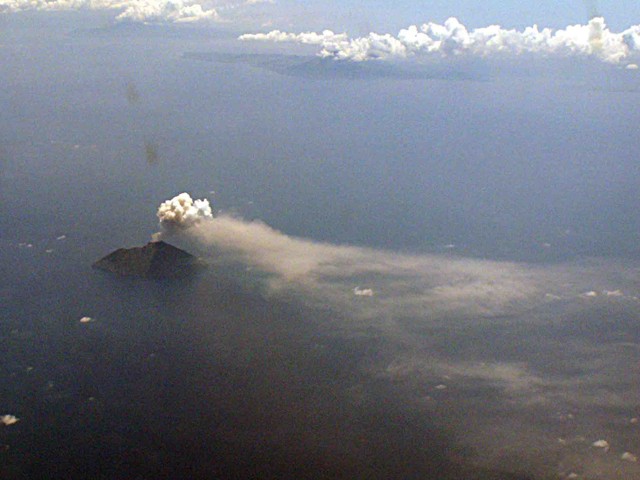 |
Figure 1. Aerial photograph of Batu Tara erupting in late March 2007 with an ash plume blowing NE. View is towards the SSE from a Garuda Boeing 737 flight between Timika, Papua New Guinea and Bali, Indonesia. Lembata Island is in the right background. Courtesy of Michael Thirnbeck. |
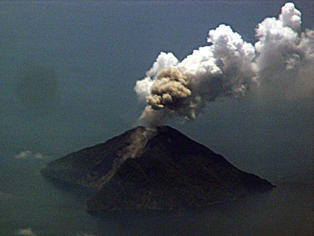 |
Figure 2. Aerial photograph of Batu Tara erupting in late March 2007 showing a steam plume and a smaller ash puff. View is towards the SE from a Garuda Boeing 737 flight between Timika, Papua New Guinea and Bali, Indonesia. The bay on the left opens to the E. Courtesy of Michael Thirnbeck. |
CVGHM reported observations from 30 March that indicated the E side of the volcano had been most impacted by recent activity. Plant life on the E side was affected by hot ashfall. White plumes rose from the summit to an altitude of ~ 1.7 km and drifted E. Incandescent rockslides and cooled lava flows were observed at the E foot of the volcano. Steam and occasional ash plumes rose from the area where hot material interacted with the sea.
Semi-continuous eruptions through 3 April produced low-level plumes, generally to altitudes of 1.5-3 km, reported by ground observers and seen in satellite imagery to distance of 37-56 km downwind in various directions. On 5 April, plumes rose to 3 km altitude. Based on satellite imagery the CVGHM reported that on 5 April a lava flow on the E slope created a central levee with debris fans on either side. The delta-like shape spanned about 450 m across. A lava flow also extended 100 m into the water. Diffuse plumes seen in satellite imagery rose to altitudes of 1.5 km and drifted W and NW during 4-11 April. Explosive activity producing noticeable ash plumes generally declined in April, and on the 12th the hazard status was lowered to Alert Level 2. However, hotspots continued to be recorded on an almost daily basis.
A pilot reported a low-level ash plume extending 90 km W on 27 April, but ash could not be identified in satellite data. Based on satellite imagery and CVGHM, the Darwin VAAC issued reports of diffuse low ash plumes drifting W during 5 and 10-12 May. On 19 June an ash plume rose to an altitude of 1.7 km. Clouds inhibited visual observations on the other days during 18-25 June. However, on 19 June, a dense white plume rising to 1,000 m high was observed. Between 28 June and 1 July, diffuse white plume was observed rising to 50-150 m. An ash column reached 750 m above the summit.
Based on observations of satellite imagery, the Darwin VAAC reported that on 18 September, diffuse ash plumes rose to an altitude of 2.4 km and drifted W for 140 km. CVGHM lowered the Alert Level to 1 on 9 October. During 3 September-9 October, plumes rose to an altitude of approximately 1.4 km, 700 m above the summit. Satellite imagery showed an ash plume on 13 October that rose to an altitude of 3 km and drifted N and W. Despite time gaps when plumes were not seen and the decreased frequency of explosion plumes, MODIS data recorded thermal anomalies at least every few days throughout April-October 2007, and continuing into February 2008.
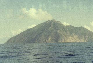
Geological Summary. The small isolated island of Batu Tara in the Flores Sea ~50 km N of Lembata (fomerly Lomblen) Island and the main volcanic arc. A scarp on the eastern side reaches the sea, and vegetation covers the other flanks to within 50 m of the summit. This volcano is noted for its potassic leucite-bearing basanitic and tephritic rocks. The first recorded eruption, during 1847-52, produced explosions and a lava flow.
Information Contacts: Center of Volcanology and Geological Hazard Mitigation (CVGHM), Diponegoro 57, Bandung, Jawa Barat 40122, Indonesia (URL: http://vsi.esdm.go.id/); Darwin Volcanic Ash Advisory Centre (VAAC), Bureau of Meteorology, Northern Territory Regional Office, PO Box 40050, Casuarina, Northern Territory 0811, Australia (URL: http://www.bom.gov.au/info/vaac/); Michael Thirnbeck, Jakarta, Indonesia (URL: http://www.flickr.com/photos/thirnbeck/); Hawai'i Institute of Geophysics and Planetology (HIGP) Thermal Alerts System, School of Ocean and Earth Science and Technology (SOEST), Univ. of Hawai'i, 2525 Correa Road, Honolulu, HI 96822, USA (URL: http://modis.higp.hawaii.edu/).