Report on Fuego (Guatemala) — December 2007

Bulletin of the Global Volcanism Network, vol. 32, no. 12 (December 2007)
Managing Editor: Richard Wunderman.
Fuego (Guatemala) Moderate Strombolian eruptions, including pyroclastic flows, continue into early 2008
Please cite this report as:
Global Volcanism Program, 2007. Report on Fuego (Guatemala) (Wunderman, R., ed.). Bulletin of the Global Volcanism Network, 32:12. Smithsonian Institution. https://doi.org/10.5479/si.GVP.BGVN200712-342090
Fuego
Guatemala
14.4748°N, 90.8806°W; summit elev. 3799 m
All times are local (unless otherwise noted)
Eruptive activity has continued at Fuego between January 2007 and early February 2008. Typical activity during this interval consisted of explosions that generated ash plumes up to ~ 2 km above the summit (~ 6 km altitude) and caused local ashfall (reported up to ~ 15 km away, but from one eruption, ~ 25 km away). Strombolian eruptions, avalanches, and lava flows up to ~ 1.5 km long were also commonly reported. Pyroclastic flows traveled up to ~ 2 km. Blocks detaching from the front of the flows and bouncing downslope were often incandescent. Satellite imagery often detected hotspots. Shock waves and rumbling or loud noises, sometimes described as similar to a passing airplane, were commonly noticed. Out last report discussed events through December 2006 (BGVN32:11).
Details included in the text below were provided by the Instituto Nacional de Sismologia, Vulcanología, Meteorología e Hidrologia (INSIVUMEH), the Coordinadora Nacional para la Reducción de Desastres (CONRED), and the Washington Volcanic Ash Advisory Center (VAAC).
The photographs included in this report are by Richard Roscoe, who on his website (www.photovolcanica.com) features more Fuego photos than we can include here. He also includes a brief animation of a small Fuego eruption. His site also provides a beginner's guide to volcano photography as well as cautions about safety and trekking in the area. All of his photos are used with his permission. They were taken during 29-31 December 2007. A companion site by his colleagues M. Rietze and Th. Boeckel also describes their photo excursion. Figures 8-10 are broadly representative of the kinds of eruptions common at Fuego during the reporting interval, and they provide a feel for the regional setting and geography.
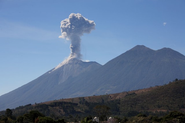 |
Figure 8. A view of Fuego in eruption as seen from the city of Antigua. Note twin church spires along the photo's lower margin. Fuego (erupting at left) is only one of several volcanoes in this photo; progressively farther towards the right peaks consist of Meseta, Acatenango (highest), and Yepocapa. This copyrighted photo is from around 29-31 December 2007. Used with permission of photographer Richard Roscoe. |
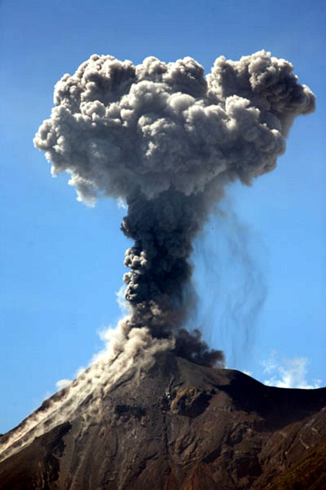 |
Figure 9. An explosive plume rising vertically above Fuego's summit on 29 December 2007, with wisps of falling ash visible on the right side. The photo was taken from Antigua. Copyrighted photo by Richard Roscoe. |
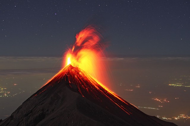 |
Figure 10. Incandescent ejecta from Strombolian eruptions of Fuego taken from the N on Acatenango volcano (~ 4 km elevation). The exact date was surmised from text as 30 December 2007. The shape of Fuego's summit has been modified by the growth of a sharp peak, presumably due to the accumulation of spatter and cinder. The night-time exposure also captured in the background the lights of towns on the Pacific coastal plain to the S. Copyrighted photo by Richard Roscoe. |
During 4-5 January 2007 gas-and-ash clouds rose to 4.2-4.8 km altitude and constant incandescent avalanches from the central crater and a lateral crater ~ 70 m from the S edge of the central crater descended SW towards Taniluyá ravine. Fine ashfall was noted in areas S and ~ 9-15 km SW of the summit. On 12 January there was explosive ejecta and ash plumes up to 4 km altitude. Incandescent material was propelled up to 75 m above the summit and incandescent blocks rolled W towards Taniluyá ravine and Santa Teresa ravine, and S towards Cenizas ravine. Explosive activity was reported again during 21-29 January when incandescent material and blocks were ejected 100 m above the summit; blocks rolled ~ 500 m S and SW. On 26 and 29 January glowing blocks from lava-flow fronts rolled S towards Cenizas ravine. During an overnight visit to a neighboring summit, Craig Chesner and Sid Halsor saw Strombolian eruptions at roughly half-hour intervals.
No activity was reported after late January until 9-13 March 2007, when lava flows were noted extending ~ 100-150 m W toward Taniluyá ravine and explosive ash plumes rose to 4-4.2 km altitude. On 12 March glowing material was ejected ~ 15-20 m above the central crater. Lava flows on 15 March and explosive incandescent ejecta thrown 200 m above crater rim were accompanied by an ash plume. The longest lava flows traveled ~ 1.5 km W toward Taniluya ravine. Similar activity continued the next day, with previous lava flows advancing and new flows seen in different ravines. Pyroclastic flows also occurred, ash plumes rose to 4-6 km altitude. Shockwaves were felt ~ 15 km away, and Strombolian eruptions propelled glowing tephra 300 m above the summit. Two pyroclastic flows traveled about 800 m; one NW, and another W and SW. During most days 21-27 March Fuego emitted explosive gas-and-ash plumes that rose to ~ 4.7-5.1 km altitude, causing ashfall in areas 5-8 km SSE and 9 km W. On 24 March explosions were followed by lava blocks rolling down the W flank toward Taniluyá ravine. Similar activity on 26 March caused ashfall in areas 10-25 km to the W and SE.
The next reports of activity, during 20-23 April, were of lava flows, pyroclastic flows, explosive incandescent ejecta 50-75 m above the vent, and a gas-and-ash plume up to 4 km altitude. Incandescent material descended 300 m down the S and W flanks. The Washington VAAC reported that an intense hotspot seen on satellite imagery on 21 April was likely caused by a lava flow to the SW. On 23 April a pyroclastic flow and incandescent avalanches traveled down SE and SW ravines; ash explosions caused light ashfall in areas S.
Observations during 17-19 May were of fumarolic emissions ~ 600 m high along with active lava flows extending ~ 100 m SW toward the Taniluyá ravine and ~ 500 m SW toward the Cenizas ravine. The lava flow from the edge of the central crater continued on the S flank (~ 150 m long); landslides of blocks of incandescent material spalled from the front of the flow into the Taniluya ravine. Activity the following week, 26-27 May, consisted of explosive ejecta ~ 100 m above vent, gray steam-and-ash plumes up to 4-4.6 km altitude, and block avalanches to the S and SW. On 28 May the lava flow on the S flank continued to advance and produce incandescent blocks that rolled W in Taniluya ravine. Explosive incandescent ejecta was seen on 29 May, along with lava flows that extended ~ 400 m SW toward Cenizas ravine and incandescent material rising tens of meters above the vent.
On 1-2 August, pyroclastic flows occurred and explosive ejecta was thrown 50-75 m above the crater rim; an ash plume rose to 5.3 km altitude. Incandescent avalanches traveled 500-700 m down the S and W flanks. On 2 August, a moderate eruption produced a pyroclastic flow that traveled ~ 2 km SSW down the Cenizas ravine. A resultant plume produced ashfall S, SW, and W for several minutes.
On 8-9 August, pyroclastic flows and explosive Strombolian activity occurred with a gas-and-ash cloud to 4.4-5.6 km altitude. This eruption was visible from the city of Antigua, even though the resulting lava flows primarily traveled down the S and W flanks, which were on the side opposite from Antigua. Clouds obscured the view of possible E-flank lava flows. Ashfall was reported in areas to the W. Lava flows and related detached blocks traveled 1.5 km down Cenizas ravine to the SW. Several pyroclastic flows descended the flanks. Ashfall was reported in villages to the W, SW, and S.
On 10-13 August, small explosions and ash plumes rose up to 4.3 km altitude. 11 August behavior was characterized by weak explosions that expelled gray ash to 500 m above the crater. On 27 August, lahars carried tree trunks, branches, and blocks down the Lajas drainage to the SE. On 28 August, explosive ash plumes rose to 4.1 km altitude. On 31 August, a lahar 8 m wide and 1.5 m thick descended W down the Santa Teresa ravine.
On 3-4 September, explosive ash plumes rose to 4.5 km altitude. On 3 September, fumarolic plumes rose to 4 km altitude and a 300 m lava flow traveled W down the Taniluya drainage. There were also avalanches in the Cenizas ravine. On 21 September explosions of gray ash rose to ~ 5.8 km altitude and incandescent pulses in the crater rose to 75 m with avalanches in the S and SW flank. On 24 September 2007, moderate and strong explosions occurred, accompanied by ash plumes extending up to 900 m above the crater, and constant degassing sounds for periods of up to 20 min. On 5 October, weak to moderate incandescent explosions occurred, accompanied by ash plumes up to 800 m above the crater, and degassing sounds. Block avalanches were noted in the Taniluyá and Santa Teresa ravines.
On 10 October, weak to moderate explosions occurred, the largest accompanied by ash plumes that rose to 4-5 km altitude. Avalanches from cone building in the inner crater went W into the Taniluyá and Santa Teresa ravines.
On 12 October, INSIVUMEH reported that explosions from Fuego produced ash plumes that rose to altitudes of 4.2-4.8 km and caused ashfall in areas to the W. The explosions were accompanied by rumbling, and degassing sounds; shock waves were detected up to15 km away. The Washington VAAC reported a thermal anomaly on satellite imagery along with ash plumes that drifted W and NW.
According to Washington VAAC, satellite imagery detected multiple ash "puffs" emitting from the volcano between 24-30 October. They also reported ash plumes on 20 November (4.6 km in altitude) and 29 November. Additional weak to moderate explosions occurred on 7 December and 12 December, expelling ash and causing degassing sounds. Shock waves were noticed up to 15 km away.
On 15 December, Fuego generated a significant ash-and-steam plume that was observed from Antigua and Guatemala. It also produced a considerable flow of ash (and possibly lava) down its E slopes. According to the Washington VAAC, satellite imagery detected a thermal anomaly on 15-16 December. Thereafter, Fuego's activity declined to normal levels, although a few moderate explosions continued, along with an occasional ash plume. An ash cloud from Fuego was observed on 21 December and 26 December 2007.
For 11 January and 24 January 2008, INSIVUMEH reported weak explosions from Fuego that produced ash plumes that rose to altitudes of 4-5 km. Small avalanches of blocks traveled W toward the Taniluyá ravine. Based on reports from INSIVUMEH, CONRED reported on 28 January that the Alert Level was lowered to Green. On 30 January, satellite imagery detected a narrow plumes of gas and possible ash. On 4 February, satellite imagery detected ash plumes that rose to an altitude of 5 km.
Geological Summary. Volcán Fuego, one of Central America's most active volcanoes, is also one of three large stratovolcanoes overlooking Guatemala's former capital, Antigua. The scarp of an older edifice, Meseta, lies between Fuego and Acatenango to the north. Construction of Meseta dates back to about 230,000 years and continued until the late Pleistocene or early Holocene. Collapse of Meseta may have produced the massive Escuintla debris-avalanche deposit, which extends about 50 km onto the Pacific coastal plain. Growth of the modern Fuego volcano followed, continuing the southward migration of volcanism that began at the mostly andesitic Acatenango. Eruptions at Fuego have become more mafic with time, and most historical activity has produced basaltic rocks. Frequent vigorous eruptions have been recorded since the onset of the Spanish era in 1524, and have produced major ashfalls, along with occasional pyroclastic flows and lava flows.
Information Contacts: Instituto Nacional de Sismologia, Vulcanología, Meteorología e Hidrologia (INSIVUMEH), Ministero de Communicaciones, Transporto, Obras Públicas y Vivienda, 7a. Av. 14-57, zona 13, Guatemala City 01013, Guatemala (URL: http://www.insivumeh.gob.gt/); Coordinadora Nacional para la Reducción de Desastres (CONRED), Av. Hincapié 21-72, Zona 13, Guatemala City, Guatemala; Washington Volcanic Ash Advisory Center (VAAC), Satellite Analysis Branch (NOAA/NESDIS), 4700 Silver Hill Road, Stop 9910, Washington, DC 20233-9910, USA (URL: http://www.ssd.noaa.gov/); Richard Roscoe (URL: http://www.photovolcanica.com/); M. Rietze, R. Roscoe, and Th. Boeckel, (website) Volcanoes of Central America, Volcan Fuego, Guatemala 29th-31st of Dec. 2007 (URL: http://www.tboeckel.de/EFSF/efsf_wv/fuego_07/fuego_07_e.htm); Craig Chesner, Eastern Illinois University, Charleston, Illinois, USA; Sid Halsor, Wilkes Barre University, Wilkes Barre, PA 18766, USA.