Report on Batu Tara (Indonesia) — July 2008
Bulletin of the Global Volcanism Network, vol. 33, no. 7 (July 2008)
Managing Editor: Richard Wunderman.
Batu Tara (Indonesia) Frequent ash plumes continued during March-August 2008
Please cite this report as:
Global Volcanism Program, 2008. Report on Batu Tara (Indonesia) (Wunderman, R., ed.). Bulletin of the Global Volcanism Network, 33:7. Smithsonian Institution. https://doi.org/10.5479/si.GVP.BGVN200807-264260
Batu Tara
Indonesia
7.791°S, 123.585°E; summit elev. 633 m
All times are local (unless otherwise noted)
Our last report on Batu Tara (BGVN 33:02), also known as Palau Komba, covered eruptive activity from 13 October 2007 through 12 March 2008. Satellite imagery during that period revealed near daily thermal anomalies and frequent plumes, at least some of which were ash-bearing. Ash or ash-and-steam plumes continued to be seen between 12 March and 25 August 2008 (table 1).
Table 1. Ash or ash-and-steam plume activity from Batu Tara, based on observations of satellite imagery and pilot reports. Courtesy of the Darwin Volcanic Ash Advisory Centre (VAAC).
| Date | Plume top altitude (km) | Drift direction(s) | Remarks |
| 12 Mar 2008 | 2.1 | SE | -- |
| 13 Apr 2008 | 2.4 | NW | -- |
| 14 Apr 2008 | 2.4 | NW, W | -- |
| 20-21 Apr 2008 | -- | -- | -- |
| 25-26 Apr 2008 | -- | -- | -- |
| 03 May 2008 | 3 | NW | -- |
| 07 May 2008 | 3 | NW | -- |
| 11-13 May 2008 | 1.8 | NW, W | Thermal anomaly on 12-13 May |
| 29 May-1 Jun 2008 | 1.8-3 | WNW, NW | Thermal anomaly on 1 June |
| 14-15 Jun 2008 | 2.1 | NW | Thermal anomaly on 14 June |
| 19-22 Jun 2008 | 1.5 | NW, W | Thermal anomaly on 20 June |
| 28 Jun 2008 | 1.8 | W, WNW | -- |
| 30 Jun 2008 | 1.8 | W, WNW | -- |
| 01 Jul 2008 | 1.8 | W, WNW | -- |
| 02-05 Jul 2008 | 1.8 | W, NW | -- |
| 08-09 Jul 2008 | 1.8 | W, NW | -- |
| 09-15 Jul 2008 | 1.8 | WNW | Thermal anomaly on 9 July |
| 16-18 Jul 2008 | 1.8 | W | Thermal anomaly on 16 July |
| 24-29 Jul 2008 | 1.5-3.7 | WSW, W, NW, N | -- |
| 30-31 Jul 2008 | 1.5 | W | -- |
| 06-08 Aug 2008 | 1.5 | W, NW | -- |
| 10-11 Aug 2008 | 1.5 | W, NW | -- |
| 14-17 Aug 2008 | 1.5 | W | -- |
| 25 Aug 2008 | 1.1-1.5 | W | Also see Tristan Burley's observations in text. |
Tristram Burley, a marine geophysicist, was on the 67-m-long motor vessel MV Bergen Surveyor passing 24 km to the N of Batu Tara on 25 August (figures 3 and 4). He observed six distinct eruptions of ash plumes from the westernmost area of the summit crater during a 45-minute period. The plumes were produced periodically roughly every 7 minutes. They rose to an estimated 350-750 m above the summit and drifted W. The N side of the island, the only part visible to him, showed no visible evidence of either lava flows or pyroclastic density currents accompanying the eruption plumes.
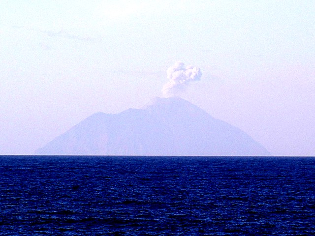 |
Figure 3. Photo of an ash plume erupting from Batu Tara on 25 August 2008, as taken from the MV Bergen Surveyor, which was about 24 km N of the volcano. Courtesy of Tristan Burley and Kenneth Rae. [Note that color has been adjusted to enhance visibility of the volcano.] |
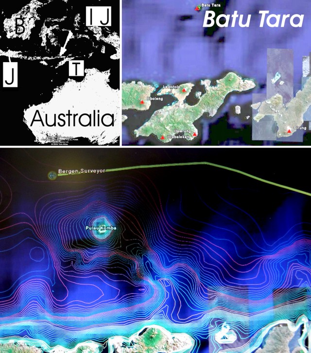 |
Figure 4. A series of maps to illustrate the setting and location of Batu Tara in the Lesser Sunda Islands of Indonesia. At upper left is a large-scale index map centered on Batu Tara (arrow tip), identifying Australia, Timor Island (T), Irian Jaya (IJ), Java (J), and Borneo (B). The map at upper right (from Google Earth) indicates Holocene volcanoes (small triangles). For scale, Batu Tara lies ~47 km N of the coast of Lembata Island (formerly Lomblen Island). At bottom is a bathymetric map of Batu Tara ("Palau Komba") and the W-traveling path of the MV Bergen Surveyor on 25 August 2008. Courtesy of Tristan Burley and Kenneth Rae. |
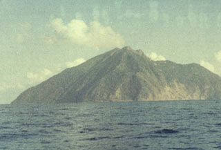
Geological Summary. The small isolated island of Batu Tara in the Flores Sea ~50 km N of Lembata (fomerly Lomblen) Island and the main volcanic arc. A scarp on the eastern side reaches the sea, and vegetation covers the other flanks to within 50 m of the summit. This volcano is noted for its potassic leucite-bearing basanitic and tephritic rocks. The first recorded eruption, during 1847-52, produced explosions and a lava flow.
Information Contacts: Darwin Volcanic Ash Advisory Centre, Bureau of Meteorology, Commonwealth of Australia (URL: http://www.bom.gov.au/info/vaac); Tristram Burley, Benfield UCL Hazard Research Centre, Department of Earth Sciences, UCL, 136 Gower Street (Lewis Building), London, WC1E 6BT UK (URL: https://www.ucl.ac.uk/hazardcentre).