Report on Klyuchevskoy (Russia) — March 2009
Bulletin of the Global Volcanism Network, vol. 34, no. 3 (March 2009)
Managing Editor: Richard Wunderman.
Klyuchevskoy (Russia) Eruption in 2007 changed summit crater; ongoing 2008-2009 lava flows
Please cite this report as:
Global Volcanism Program, 2009. Report on Klyuchevskoy (Russia) (Wunderman, R., ed.). Bulletin of the Global Volcanism Network, 34:3. Smithsonian Institution. https://doi.org/10.5479/si.GVP.BGVN200903-300260
Klyuchevskoy
Russia
56.056°N, 160.642°E; summit elev. 4754 m
All times are local (unless otherwise noted)
Significant eruptions resumed in mid-February 2007. Our last report on Kliuchevskoi (BGVN 32:06) chronicled activity during April 2005-July 2007. This report covers the period from August 2007 to April 2009.
An eruptive period from February to July 2007 reached peak intensity on 29 June 2007 (BGVN 32:06). The ash column was sustained and reached an estimated 8 km high during an 8 hour interval. Plumes reached 2,000 km long. This energetic eruption produced substantial changes to the summit morphology, including removal of the cinder cone on the floor of the summit crater, leaving a deeper crater there. This followed a pattern of earlier substantial morphological change in the summit region during the interval 1968-2007.
Figure 8 shows the pattern of changes during 1968 to mid-2007, but does not show events beyond the time of the 29 June 2007 eruption. Alexey Ozerov (Institute of Volcanology and Seismology, IVS) flew over the volcano during August 2007 and was the first to observe that, following the large eruption, the cinder cone was gone and the crater floor had dropped to an extent that the crater had developed an open capacity of 0.5 km3. The earlier events shown on figure 8 documents over 600 m of vertical change in the position of the crater floor or the tops of cinder cones on the floor.
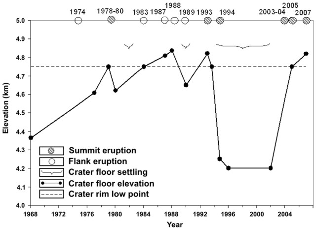 |
Figure 8. A plot showing the height of the crater floor and intra-crater cones at Kliuchevskoi during 1968-2007. The date of the 29 June 2007 eruption was added by editors, but the extent of post-eruptive topographic changes is not shown. Symbols at the top describe eruption types; crater floor elevation was measured at the dots. After Zharinov and Demyanchuk, 2008. |
Activity during 2008. Preceding the next eruption, increasing seismic activity and thermal alerts were seen during June to October 2008. On 7 August the color code was raised from Green to Yellow due to increased earthquakes and intermittent tremor. A thermal anomaly was registered over the volcano.
Beginning on 8 October observers noted an explosive-effusive summit eruption that included mainly Strombolian activity. On that day the color code was raised to Orange.
During October-November 2008 analysis of satellite imagery revealed a thermal anomaly in the crater. Lava began filling the crater. Nighttime observers saw the crater rim glowing and lava fountains at least 300 m tall. Extensive lava flows developed by late October (figure 9). From 28 October to 4 November bursting sounds from the volcano were heard in Klyuchi, about 30 km to the NE.
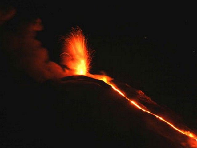 |
Figure 9. Strombolian eruption and associated lava flow down the NW flank seen at Kliuchevskoi on 31 October 2008. Photo by Yuri Demyanchuk. |
On 21 November 2008, lava flows advanced on the NW slope. They descended to 3 km elevation. Gas-and-steam plumes drifted 80 km NW on 24 November and 20-40 km SE during 25-26 November.
The mostly active period continued from late November 2008 to early January 2009. During 28 November-10 December, Strombolian activity ejected bombs 500 m above the crater and lava effusion on the NW flank continued. Analysis of satellite imagery revealed large daily thermal anomalies in the crater. On 8 December the front of the lava flow made contact with the thick portion of the Erman Glacier, causing phreatic bursts and mudflows (figure 10). A very similar process occurred during the 2007 eruption (BGVN 32:06), and the December line of descent was also the same as in 2007. During 8-10 December, ash plumes rose to altitudes of 7.5-8 km, and drifted about 700 km E.
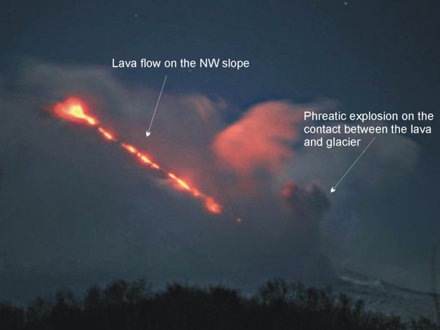 |
Figure 10. Lava descending Kliuchevskoi's NW slope. Lava from the crater descended over glaciers and where ice was thick in mid-flank areas, phreatic eruptions occurred. Undated photo by Yuri Demyanchuk. |
During the final phase of the eruption (16 January-16 April 2009) the magnitude of volcanic tremor rapidly decreased. The volcano generated ash plumes extending 80-90 km to the NE. Fumarolic activity was seen during last days of April (figure 11).
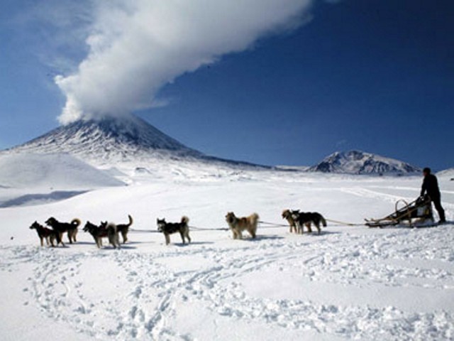 |
Figure 11. Crossing alpine snow fields at the foot of Kliuchevskoi, a dogsled team pauses as the mountain emits gas and steam plumes on 9 April 2009. Photo by Yuri Demyanchuk. |
As noted by Zharinov and Demyanchuk (2008), Shirokov (1985) studied the timing of Kliuchevskoi's volcanic eruptions with respect to lunar cycles. He found that eruptions were associated with a Moon-Earth rotational cycle of 18.6 years duration. According the Zharinov and Demyanchuk (2008), Shirokov (1985) forecast an eruptive interval during May 2006-May 2009.
References. Shirokov, V.A., 1985, Some questions method forecast flank eruption at Kliuchevskoi (Kamchatka): Volcanology and Seismology, no. 6, p. 48-58 (in Russian).
Zharinov, N.A., and Demyanchuk, Yu.V., 2008, The summit eruption of Kliuchevskoi volcano in 2007 (Kamchatka): Conference proceedings, dedicated to the day of volcanologists, on 27-29 March, 2008, Petropavlovsk-Kamchatsky: Insitute of Volcanology and Seismology, Far East Division, Russian Academy of Sciences, p. 81-89 (in Russian).
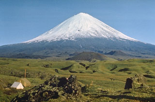
Geological Summary. Klyuchevskoy is the highest and most active volcano on the Kamchatka Peninsula. Since its origin about 6,000 years ago, this symmetrical, basaltic stratovolcano has produced frequent moderate-volume explosive and effusive eruptions without major periods of inactivity. It rises above a saddle NE of Kamen volcano and lies SE of the broad Ushkovsky massif. More than 100 flank eruptions have occurred during approximately the past 3,000 years, with most lateral craters and cones occurring along radial fissures between the unconfined NE-to-SE flanks of the conical volcano between 500 and 3,600 m elevation. Eruptions recorded since the late 17th century have resulted in frequent changes to the morphology of the 700-m-wide summit crater. These eruptions over the past 400 years have originated primarily from the summit crater, but have also included numerous major explosive and effusive eruptions from flank craters.
Information Contacts: Kamchatka Volcanic Eruptions Response Team (KVERT), Institute of Volcanology and Seismology (IVS), Kamchatka Branch of the Geophysical Service of the Russian Academy of Sciences (KB GS RAS), Far East Division, Russian Academy of Sciences, Piip Ave. 9, Petropavlovsk-Kamchatsky, 683006, Russia (URL: http://www.kscnet.ru/ivs/kvert/); Olga Girina and Yuri Demyanchuk, KVERT, Institute of Volcanology and Seismology (IVS); Alexei Ozerov, Active Volcanism Laboratory, Institute of Volcanology and Seismology (IVS).