Report on Deception Island (Antarctica) — March 2009
Bulletin of the Global Volcanism Network, vol. 34, no. 3 (March 2009)
Managing Editor: Richard Wunderman.
Deception Island (Antarctica) Absence of seismicity, deformation, and soil temp flux during late 2008-early 2009
Please cite this report as:
Global Volcanism Program, 2009. Report on Deception Island (Antarctica) (Wunderman, R., ed.). Bulletin of the Global Volcanism Network, 34:3. Smithsonian Institution. https://doi.org/10.5479/si.GVP.BGVN200903-390030
Deception Island
Antarctica
62.9567°S, 60.6367°W; summit elev. 602 m
All times are local (unless otherwise noted)
Alicia Garcia forwarded to us a report of the geophysical monitoring conducted during December 2008 to February 2009 (the 2008-2009 austral summer). This field work included measurements of seismicity, deformation, and soil temperature. Little if any unrest was detected.
The volcanic alert remained Green during the 2008-2009 campaign. The volcano last erupted in 1970 (and several uncertain eruptions were indicated since then). Seven seismic stations, and a seismic array determined that seismicity was low. During January and February 2009 instruments detected some earthquakes attributed to hydrothermal processes and ice melting. Geodetic leveling surveys were carried out over benchmarks along six lines of an existing network (known as RENID). Only superficial deformation was detected.
The Thermometric Monitoring Network (THONET) was initiated in 2006. It consists of a set of stations monitoring micro-meteorological variables including wind velocity, air temperature and humidity, upward and downward solar and terrestrial radiation, diffuse solar radiation, soil heat flow, soil temperature at several depths and snow depth cover. Not all variables are recorded at all stations or constantly. Measurements indicated that soil thermal behavior was the result of solar and atmospheric forcing.
Ibanez and others (2003) noted both long-period (LP) and volcano-tectonic (VT) earthquakes since 1986, with greatest intensity during 1992 and 1999. This means that in ~ 15 years of seismic monitoring, two intense volcanic crises have been observed. No permanent monitoring stations exist on the island, and seismic measurements are conducted only during 3 months/year (from December to February); thus, similar periods of elevated volcanic seismicity might have occurred more often than detected.
Benitez and others (2007) described a seismic-event classification and monitoring system for Deception. The system, based on hidden Markov modeling (HMM) techniques, enabled monitoring by careful discriminating among different signal types.
As late as 30 April 2009, MODIS/MODVOLC thermal alert satellite measurements showed no anomalies over the island since at least 2000.
References. Benítez, M.C., Ramírez, J., Segura, J.C., Ibáñez, J.M., Almendros, J., García-Yeguas, A., and Cortés, G., 2007, Continuous HMM-Based Seismic-Event Classification at Deception Island, Antarctica, IEEE Transactions on Geoscience and Remote Sensing, v. 45, no. 1, p. 138-146.
Ibáñez, J.M, Almendros, J., Carmona, E., Martínez-Arévalo, C., and Abril, M., 2003, The recent seismo-volcanic activity at Deception Island volcano, Deep Sea Research Part II: Topical Studies in Oceanography, v. 50, no. 10-11, p. 1611-1629.
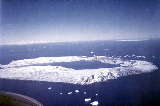
Geological Summary. Ring-shaped Deception Island, at the SW end of the South Shetland Islands, NE of Graham Land Peninsula, was constructed along the axis of the Bransfield Rift spreading center. A narrow passageway named Neptunes Bellows provides an entrance to a natural harbor within the 8.5 x 10 km caldera that was utilized as an Antarctic whaling station. Numerous vents along ring fractures circling the low 14-km-wide island have been reported active for more than 200 years. Maars line the shores of 190-m-deep Port Foster caldera bay. Among the largest of these maars is 1-km-wide Whalers Bay, at the entrance to the harbor. Eruptions during the past 8,700 years have been dated from ash layers in lake sediments on the Antarctic Peninsula and neighboring islands.
Information Contacts: A. Garcia, Dept. of Volcanology (MNCN-CSIC), Madrid, Spain; M. Berrocoso, Cadiz Univ., Spain; M. Rodríguez-Arias, Extremadura Univ., Spain; I. Serrano, Granada Univ., Spain; MODIS/MODVOLC. Hawai'i Institute of Geophysics and Planetology (HIGP) Thermal Alerts System, School of Ocean and Earth Science and Technology (SOEST), Univ. of Hawai'i, 2525 Correa Road, Honolulu, HI 96822, USA (URL: http://modis.higp.hawaii.edu/).