Report on Dieng Volcanic Complex (Indonesia) — April 2009
Bulletin of the Global Volcanism Network, vol. 34, no. 4 (April 2009)
Managing Editor: Richard Wunderman.
Dieng Volcanic Complex (Indonesia) Landslide triggers sudden, small, phreatic eruption on 15 January 2009
Please cite this report as:
Global Volcanism Program, 2009. Report on Dieng Volcanic Complex (Indonesia) (Wunderman, R., ed.). Bulletin of the Global Volcanism Network, 34:4. Smithsonian Institution. https://doi.org/10.5479/si.GVP.BGVN200904-263200
Dieng Volcanic Complex
Indonesia
7.2°S, 109.879°E; summit elev. 2565 m
All times are local (unless otherwise noted)
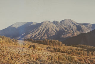
This report discusses a small phreatic eruption at Dieng from Sibanteng crater in January 2009. The Dieng complex covers more than 80 km2 in Central Java NW of Yogyakarta. The volcanic field trends E and contains two or more stratovolcanoes, more than 20 craters and cones, several crater lakes, a caldera, and active thermal features (van Bergen and others, 2000). Phreatic eruptions are those that eject both magmatic gasses and steam, and contain fragments of pre-existing solid rock from the volcanic conduit or vent, but without primary erupted magma. Many of these eruptions are attributed to subsurface interaction between magma and groundwater (Germanovich and Lowell, 1995). Some are precursors to phreatomagmatic and magmatic eruptions.
Recent reports discussed mud ejected from the active Sileri crater in July 2003 associated with a modest increase in seismicity and steam plumes during April-July 2002 and August 2003 (BGVN 27:05, 28:06, 28:07, and 28:09). A May 2005 pilot report of a steam plume turned out to be caused by pipe maintenance at Dieng's geothermal site.
January 2009 landslide and eruption. This event began when, after three days of heavy rain, one or more landslides broke loose in steep volcanic terrain at about the 1900- to 2000-m elevation at 0800 on 15 January 2009. Landslide debris covered the floor of Sibanteng crater, sealing the vent there. At 0830 a sudden and short-lived phreatic eruption took place. The alert level was raised to 2 (on a scale of 1 to 4).
Much of these and other details were learned by an emergency response team from the Center of Volcanology and Geological Hazard Mitigation (CVGHM), who conducted a field investigation between 16-21 January. The team's findings are discussed below (as extracted from the CVGHM report dated 22 January 2009 ("Tanggap Darurat G. Dieng Kab. Wonosobo, Prov. Jawa Tengah, tanggal 16-21 Januari 2009").
The eruption left an explosion crater about 50 m in diameter and deposited the bulk of the erupted material in a ~ 50 m radius. The erupted deposits consisted of material from the landslide and vent area. This relationship indicated that the landslide preceded the phreatic eruption. The landslides covered an area 100 x 200 m, with an estimated 40,000 m3 of debris. In places, the landslide debris created temporary dams. One blocked the Kali Putih River, and downstream, the Kali Tulis River.
On 17 January, four additional seismic stations were installed. Three were in the vicinity of the Sibanteng and Sikidang craters and one was near the thermally active colored lake Telaga Warna. Earthquakes and tremor were both absent on the seismographic record at Timbang crater during 17-20 January following the phreatic eruption.
The team reported that witnesses in the field had heard two explosions. The first came from the landslide; the second, the phreatic eruption. During their visit, the eruption vent emitted a white plume 5 m high. The vent was largely covered by landslide debris from Sibanteng crater's upper wall. In Sibanteng and other craters temperature ranges were 93.2-93.6° C, values similar to previous data.
The concentrations of gases, including hydrogen sulfide (H2S), sulfur dioxide (SO2), methane (CH4), carbon dioxide (CO2), and carbon monoxide (CO) were reported for eight locations. The CO and CO2 concentrations were below ~ 1 ppm. H2S concentrations were under ~ 7 ppm, with the highest value seen near a thermal feature at Skikdang, but a 6 ppm value near a bulletin board in a tourist area. The eight SO2 concentrations were under 18 ppm. CH4 concentrations ranged between 5 and 17 ppm. (More detailed data are available in the 22 January CVGHM report.)
The investigation indicated that the phreatic eruption was preceded by one or more landslides that covered the floor of Sibanteng crater. The team suggested that the sealing action and pressure buildup due to the landslide caused the phreatic eruption. They concluded that the phreatic eruption posed no danger to the public because the Sibanteng crater is not close to an inhabited area. However, they noted that landslide debris was still unstable and could be easily dislodged and transported by rainwater.
Reference. Germanovich, L.N., and Lowell, R.P., 1995, The mechanism of phreatic eruptions: J. Geophys. Res., v. 100 (B5), p. 8417-8434.
van Bergen, M.J., Bernard, A., Sumarti, S., Sriwana, T., and Sitorus, K., 2000, Crater lakes of Java: Dieng, Kelud and Ijen, Excursion Guidebook, IAVCEI General Assembly, Bali 2000 (URL: www.ulb.ac.be/sciences/cvl/DKIPART1.pdf).
Geological Summary. The Dieng plateau in the highlands of central Java is renowned both for the variety of its volcanic scenery and as a sacred area housing Java's oldest Hindu temples, dating back to the 9th century CE. The Dieng Volcanic Complex consists of multiple stratovolcanoes and more than 20 small Pleistocene-to-Holocene craters and cones over a 6 x 14 km area. Prahu stratovolcano was truncated by a large Pleistocene caldera, which was subsequently filled by a series of cones, lava domes, and craters, many containing lakes. Lava flows cover much of the plateau, but observed activity has been restricted to minor phreatic eruptions. Gas emissions are a hazard at several craters and have caused fatalities. There are abundant thermal features and high heat flow across the area.
Information Contacts: Center of Volcanology and Geological Hazard Mitigation (CVGHM), Jalan Diponegoro 57, Bandung 40122, Indonesia (URL: http://vsi.esdm.go.id/).