Report on Bezymianny (Russia) — November 2009
Bulletin of the Global Volcanism Network, vol. 34, no. 11 (November 2009)
Managing Editor: Richard Wunderman.
Bezymianny (Russia) Lava dome growth and explosive 17 December 2009 eruption
Please cite this report as:
Global Volcanism Program, 2009. Report on Bezymianny (Russia) (Wunderman, R., ed.). Bulletin of the Global Volcanism Network, 34:11. Smithsonian Institution. https://doi.org/10.5479/si.GVP.BGVN200911-300250
Bezymianny
Russia
55.972°N, 160.595°E; summit elev. 2882 m
All times are local (unless otherwise noted)
Dome growth continued at Bezymianny (figure 8) in the aftermath of the extensive eruption of 9 May 2006 (BGVN 31:04), with later eruptions on 12 May 2007 (BGVN 32:11) and a previously unreported substantial one on 19 August 2008. Another one occurred on 17 December 2009. This report covers the interval from August 2008 to mid-January 2010.
 |
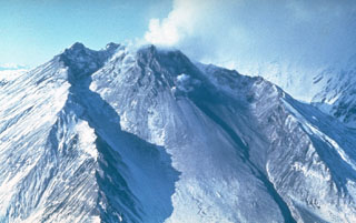
Figure 8. July 2009 aerial photo of Bezymianny showing the eroded outer S flank in the foreground, the dome in the mid-ground, and Kamen volcano in the distance. The fresh 2009 lava flow (black) moves down the dome towards the viewer. Courtesy of Pavel Izbekov (Alaska Geophysical Institute). |
Explosion of 19 August 2008. The explosion produced an ash plume that rose to ~ 9 km altitude and drifted 1,200 km W. Staff at a seismic station ~ 50 km W reported ashfall and the smell of volcanic gas. Analysis of satellite imagery revealed thermal anomalies on the lava dome during 14-15 and 18-21 August 2008. Moreover, the thermal anomalies enlarged just before the 19 August explosion.
Thermal images and photos. During much of the interval September to December 2009, satellite images depicted thermal anomalies of 1-2 pixels in the crater area. These occurred, for example, 21 and 30 May, and 2-4, 7, and 11-14 June 2009. After the 17 December 2009 eruption (discussed below) more pixels appeared through mid-January 2010). When the volcano was visible, weak fumarolic emissions rose 50 m and blew NE to E.
A 5 September 2009 photograph of Bezymianny (figure 9) shows the volcano's famous horseshoe-shaped crater rim formed during sector collapse in a 1956 eruption. A lava flow traveled down the steaming lava dome.
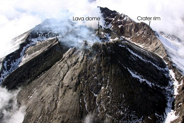 |
Figure 9. An aerial photo taken at an oblique high-angle at Bezymianny, showing active lava flows moving down slope on the dome and moderate degassing occurring at the summit. View from the E side. Photo taken 5 September 2009 by Sergey Ushakov (IV&S FED RAS). |
Seismicity. During the reporting interval, instruments recorded only a few seismic events. They took place on 13 October 2008, M 1.35 (Ks 4.2); on 5 June 2009, M 1.65 (Ks 4.8); on 24 June 2009, M 1.25 (Ks 4.0); on 5 August 2009, M 2.0 (Ks 5.5); and on 12 October 2009, M 2.1 (Ks 5.7). That said, the record of the volcano's seismicity was hard to decifer between 21 October 2008 and 16 January 2009 because of strong overriding signals from an eruption nearby at Kliuchevskoi. A large number of hypocenters were registered beneath Kliuchevskoi between 21 April and 17 November 2009 (figure 10).
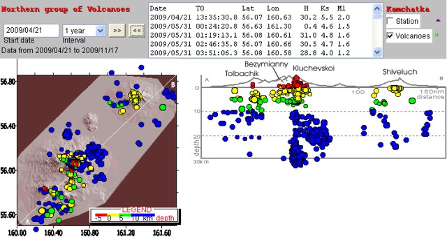 |
Figure 10. Seismicity of Kamchatka's Northern group of volcanoes (Shiveluch, Kliuchevskoi, Ushkovsky, Krestovsky, Bezymianny, Tolbachik) recorded during April-November 2009. Map (left) shows location and depths of earthquakes (white line is cross-section AB). Cross-section shows hypocenters projected onto the vertical plane along AB. Courtesy of the Kamchatka Branch of the Geophysical Service of the Russian Academy of Sciences (KB GS RAS). |
17 December 2009 eruption. Bezymianny's eruption began at 0945 on 17 December (2145 UTC on 16 December). From Atlasovo village, almost 100 km to the S, observers saw an unusually large ash cloud in a shape newspaper reporters described as reminiscent of a mushroom-cloud from a nuclear blast.
KVERT estimated the ash column height to be ~ 15 km altitude, extending to the NW, and stretching more than 350 km from the volcano. The plume's width was at least 35 km. The plume's axis passed over Kozyrevsk village where the ash thickness reached 2-3 mm (figure 11). With approach to Bezymianny, ashfall was plentiful.
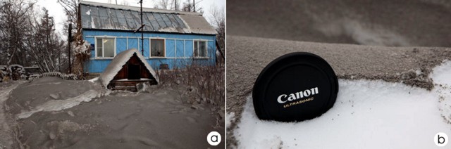 |
Figure 11. Deposit of Bezymianny ash in Kozyrevsk village area as photographed on 17 December 2009. One frame (a) shows a cottage with ash over snow-covered landscape (2-3 mm thickness); the other (b) shows close up of ash layer on top of snow. Courtesy of Yuri Demyanchuk (KVERT). |
The Geophysical Service reported that seismicity was at normal background levels during 1-5 December and gradually increased from 6 December to 16 December 2009. According to satellite data, thermal anomalies registered during 14 December 2009 to mid-January 2010 (figure 12). Thick deposits of pyroclastic flows and related tephra lay on the volcano's slopes. The large amount of material erupted suggested that a crater formed on the dome.
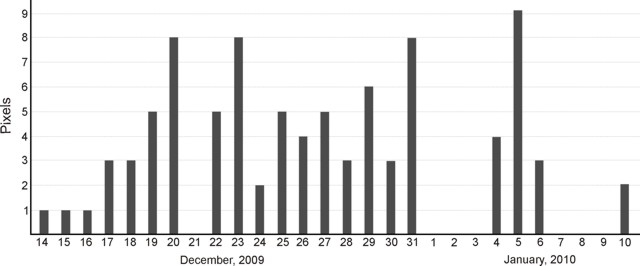 |
Figure 12. A plot showing the thermal anomalies detected at Bezymianny during 14 December 2009 to 10 January 2010. Plot made from AVO and KB GS RAS data. |
Ash plumes soon ceased, but steam was abundant. During 18 December observers noted a gas-steam emission stretching 30 km NW. On 20-22 December, steam plumes reached 10-30 km to the S.
Thermal anomalies were detected extending from the crater down onto the E flank starting at 2315 (1115 UTC) on 17 December that lasted at least 85 minutes, into the 18th. More anomalies were present during satellite passes on 21-23 December, with the last MODVOLC alerts recorded during 25-26 December 2009.
Geological Summary. The modern Bezymianny, much smaller than its massive neighbors Kamen and Kliuchevskoi on the Kamchatka Peninsula, was formed about 4,700 years ago over a late-Pleistocene lava-dome complex and an edifice built about 11,000-7,000 years ago. Three periods of intensified activity have occurred during the past 3,000 years. The latest period, which was preceded by a 1,000-year quiescence, began with the dramatic 1955-56 eruption. This eruption, similar to that of St. Helens in 1980, produced a large open crater that was formed by collapse of the summit and an associated lateral blast. Subsequent episodic but ongoing lava-dome growth, accompanied by intermittent explosive activity and pyroclastic flows, has largely filled the 1956 crater.
Information Contacts: Kamchatka Volcanic Eruptions Response Team (KVERT), Institute of Volcanology and Seismology (IV&S) Far East Division, Russian Academy of Sciences (FED RAS), Kamchatka Branch of the Geophysical Service of the Russian Academy of Sciences (KB GS RAS), Piip Ave. 9, Petropavlovsk-Kamchatsky, 683006, Russia (URL: http://www.kscnet.ru/ivs, http://www.emsd.ru/~ssl/monitoring/main.htm); Sergei Ushakov, IV&S FED RAS; Tokyo Volcanic Ash Advisory Center (VAAC), Tokyo, Japan (URL: http://ds.data.jma.go.jp/svd/vaac/data/); Alaska Volcano Observatory (AVO), a cooperative program of the U.S. Geological Survey, the University of Alaska's Geophysical Insitute, and the Alaska Division of Geological & Geophysical Surveys (URL: http://www.avo.alaska.edu/); Hawai'i Institute of Geophysics and Planetology (HIGP) Thermal Alerts System, School of Ocean and Earth Science and Technology (SOEST), Univ. of Hawai'i, 2525 Correa Road, Honolulu, HI 96822, USA (URL: http://modis.higp.hawaii.edu/); Pravda On-Line (URL: http://www.pravda.ru/news/accidents/19-12-2009/1004964-volcano-0/); RIA Novosti News (URL: http://www.rian.ru/).