Report on Concepcion (Nicaragua) — November 2009
Bulletin of the Global Volcanism Network, vol. 34, no. 11 (November 2009)
Managing Editor: Richard Wunderman.
Concepcion (Nicaragua) Explosive ash eruptions in 2007, July 2008, and December 2009
Please cite this report as:
Global Volcanism Program, 2009. Report on Concepcion (Nicaragua) (Wunderman, R., ed.). Bulletin of the Global Volcanism Network, 34:11. Smithsonian Institution. https://doi.org/10.5479/si.GVP.BGVN200911-344120
Concepcion
Nicaragua
11.538°N, 85.622°W; summit elev. 1700 m
All times are local (unless otherwise noted)
Recent volcanism at Concepción has consisted of small ash explosions that take place intermittently, often many months apart. Four months of quiet ended with crater explosions on 9 February, 8 April, and 22 April 2007 (BGVN 32:07). Ash-bearing eruptions were later reported by the Nicaraguan Institute of Territorial Studies (INETER) during June-July 2007, November-December 2007, July 2008, and December 2009.
INETER noted two small explosions on 5 June 2007 that caused ashfall in Moyogalpa, along the W coast. A larger explosion took place on the morning of 10 July 2007. Most of the tephra from the 10 July explosion fell into the lake, forming what looked like a wall to distant observers. Material that fell on land caused the burning of crops, especially in areas to the W (figure 4), such as Moyogalpa. During 24-25 July fieldwork was conducted by INETER staff and visiting scientists. Fragments of rocks thrown by the 10 July explosion reached diameters of up to 7-10 cm. The lithic fragments were basaltic, with many crystals, including some plagioclase, but no juvenile material was identified.
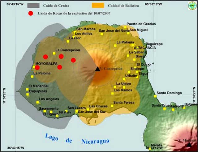 |
Figure 4. Map of Concepción (NE end of Ometepe Island in Lake Nicaragua) showing areas of projected ashfall (caida de ceniza) and ballistic bombs (caidad de balistico). The five large dots, extending from the crater W towards Moyogalpa, indicate where ejected rock actually fell during the 10 July 2007 explosion. Ash also fell within the zone identified as being at risk for ashfall. N is towards the top; for scale, an E-W line through the summit and across this part of the island is 14.5 km long. After Delgado and Navarro (2002), from El Nuevo Diario (11 July 2007); courtesy of INETER. |
On 24 November 2007 another episode of volcanic activity began, with gas emissions followed by two moderate explosions from the main crater. Ash was blown downwind and deposited in small amounts on Ometepe Island and in Bethlehem, Potosi, and Buenos Aires. Activity decreased after about two hours that day, but ash-and-gas explosions continued until the first week of December. Seismicity remained strong throughout December 2007. On 20 December there was another small explosion followed by emission of gas and ash. Civil Defense reported that the ash was deposited in small amounts on Ometepe Island and was transported by the wind towards the towns of San Jorge, Belén, Potosí and Buenos Aires.
Low levels of seismicity continued, but there were no explosions recorded, during January-June 2008. On 30 July 2008 the seismic station located in the Concepción volcano recorded a strong seismic event. Civil Defense officials in the city of Rivas reported that at that time there had been two explosions, ten minutes apart, that caused minor ashfall in Moyogalpa and La Concha. No additional volcanic activity was reported in 2008.
As during the second half of 2008, no explosive activity was reported during 2009 until mid-December. Citing INETER, news media reported that an eruption of gas and ash on the morning of 11 December rose up to ~ 150 m high. Ash fell to the SW in the towns of Los Angeles, Esquipulas and San Jose del Sur.
Reference. Delgado, G.H., and Navarro, M., 2002, Mapa de amenaza volcánica, Volcán Concepción: Geofísica UNAM/México, JICA, Instituto Mexicano de Cooperación Internacional.
Geological Summary. Volcán Concepción is one of Nicaragua's highest and most active volcanoes. The symmetrical basaltic-to-dacitic stratovolcano forms the NW half of the dumbbell-shaped island of Ometepe in Lake Nicaragua and is connected to neighboring Madera volcano by a narrow isthmus. A steep-walled summit crater is 250 m deep and has a higher western rim. N-S-trending fractures on the flanks have produced chains of spatter cones, cinder cones, lava domes, and maars located on the NW, NE, SE, and southern sides extending in some cases down to Lake Nicaragua. Concepción was constructed above a basement of lake sediments, and the modern cone grew above a largely buried caldera, a small remnant of which forms a break in slope about halfway up the N flank. Frequent explosive eruptions during the past half century have increased the height of the summit significantly above that shown on current topographic maps and have kept the upper part of the volcano unvegetated.
Information Contacts: Instituto Nicaraguense de Estudios Territoriales (INETER), Apartado Postal 2110, Managua, Nicaragua (URL: http://www.ineter.gob.ni//geofisica.html); Agence-France Presse (URL: http://www.afp.com/).