Report on Fuego (Guatemala) — December 2009

Bulletin of the Global Volcanism Network, vol. 34, no. 12 (December 2009)
Managing Editor: Richard Wunderman.
Fuego (Guatemala) Many small ash plumes and some lava flows during 2008-2009; instrumented study
Please cite this report as:
Global Volcanism Program, 2009. Report on Fuego (Guatemala) (Wunderman, R., ed.). Bulletin of the Global Volcanism Network, 34:12. Smithsonian Institution. https://doi.org/10.5479/si.GVP.BGVN200912-342090
Fuego
Guatemala
14.4748°N, 90.8806°W; summit elev. 3799 m
All times are local (unless otherwise noted)
The current eruption from Fuego, located ~40 km WSW of the country's main airport (La Aura) and 17 km NE of the historic city of Antigua, has been ongoing since 2002. The Instituto Nacional de Sismologia, Vulcanología, Meteorología e Hidrologia (INSIVUMEH) monitors this volcano, providing regular observations. During the current reporting interval, 11 January 2008-12 January 2010, minor ash plumes were common, typically rising several hundred meters above the summit (tables 5 and 6). Some were incandescent. Plumes often drifted 5-15 km from the vent and residents in the region sometimes noted noise and shock waves. Observers occasionally saw avalanches and lahars, and sometimes an active lava flow traveled ~100 m from its vent. On 30 January 2009 observers saw incandescent material ejected 50-100 m above the crater and avalanches from the crater rim descended multiple ravines.
Table 5. Summary of reported activity at Fuego volcano for January 2008-December 2008. "--" indicates no data. Information courtesy of INSIVUMEH, Washington Volcanic Ash Advisory Center (VAAC), and HIGP Thermal Alerts System.
| Dates | Explosions | Ash Plumes Altitude (km) | Plume Drift | Other observations |
| 11 Jan 2008 | weak | 4.1-4.3 | -- | Alert Level Yellow. |
| 24 Jan 2008 | shock waves detected 3 km away | 4.2-4.5 | S, SW, W | Avalanches of blocks traveled W towards Taniluya ravine; Alert Level lowered to Green. |
| 04 Feb 2008 | multiple | 5 | W | -- |
| 06-19 Feb 2008 | multiple | 4-4.7 | -- | Fumarolic plumes. |
| 22-25 Mar 2008 | 4-5/hour | 4.1-4.6 | 6-8 km S, SE | Noise/shock waves felt 5-8 km distant. |
| 31 Mar-01 Apr 2008 | multiple | -- | SW | -- |
| 15-21 Apr 2008 | 1-2/hour | 4.3-4.7 | 5-8 km SW | Noise/shock waves felt 5-15 km distant. |
| 28 Apr 2008 | 1/hour | 4.4 | 5 km SW | Noise audible 15 km distant. |
| 22-27 May 2008 | multiple | 4.1-4.5 | 5 km SW | Noise/shock waves felt 10-15 km distant; constant avalanches of blocks traveled W towards Taniluya and Santa Teresa ravines. |
| 28-30 May 2008 | many | 4.1-4.4 | S, SW | Noise/shock waves felt several km away; avalanches of blocks traveled W into Taniluya and Santa Teresa ravines. |
| 02 Jun 2008 | -- | -- | -- | Incandescent material ejected 50-100 m above crater; small lava flow traveled 100 m W towards Santa Teresa ravine. |
| 13-17 Jun 2008 | -- | 3.9-4.4 | -- | On 13 Jun lahars descended Santa Teresa (W) and Ceniza (SW) drainages; a lava flow traveled 100 m towards Santa Teresa; on 15 Jun rumbling noises accompanied by shock waves; on 17 Jun fumarolic plumes noted and incandescent material ejected ~50 m above crater. |
| 18 Jun 2008 | -- | 4.3 | W, SW | Incandescent material ejected 50 m above crater; constant avalanches of blocks traveled W; rumbling/degassing noises. |
| 20 Jun 2008 | -- | -- | -- | Lahar that was hot in areas descended Ceniza drainage to SW, dragging tree branches and blocks 0.5-1 m in diameter. |
| 04 Jul 2008 | multiple | -- | -- | Lava flow traveled 100 m W toward Santa Teresa ravine; lahar carrying blocks descended Ceniza ravine to SW. |
| 07-08 Jul 2008 | many | 4-4.5 | S, SE, SW | Incandescence at summit; constant avalanches of blocks from lava-flow fronts descended W flank. |
| 31 Jul 2008 | -- | -- | -- | Lahar descended El Jute River to SE. |
| 01 Aug 2008 | many | 4.1 | W, SW | Rumbling noises and shockwaves occasionally accompanied explosions. |
| 20 Aug 2008 | -- | -- | -- | Lahars descended several rivers carrying blocks up to 1 m diameter. |
| 25-26 Aug 2008 | many | 4.1 | SW | 300-m long lava flow traveled W towards Santa Teresa ravine. |
| 18 Sep 2008 | -- | 4.3 | SSW | -- |
| 24 Sep 2008 | many | 4.1 | W | Lava flow traveled 300 m W towards Seca ravine; avalanches generated by lava flow front. |
| 20-21, 25 Nov 2008 | many | 4.1-4.6 | W, S | Rumbling/degassing noises and shock waves detected 10 km away; lava flowed 150 m towards Taniluya ravine; incandescent material rolled down flanks. |
| 12 Dec 2008 | many | 4.1-5 | SSW | Rumbling/degassing noises and shock waves detected 10 km away. |
Table 6. Summary of reported activity at Fuego volcano for January 2009-January 2010. "--" indicates no data. Information courtesy of INSIVUMEH, Washington Volcanic Ash Advisory Center (VAAC), and HIGP Thermal Alerts System.
| Dates | Explosions | Ash Plumes Altitude (km) | Plume Drift | Other observations |
| 04-06 Jan 2009 | multiple | 4.1-5.1 | 12 km W, SW | Rumbling noises and shock waves detected 10 km away; constant avalanches of blocks descended S and SW flanks. |
| 08-09 Jan 2009 | 3-5/hour | 4.3-5.4 | 10-15 km S, SW | Rumbling noises and shock waves detected 10-15 km away; constant avalanches of blocks descended S and SW flanks. |
| 19-20 Jan 2009 | many | 4.1-4.6 | 7 km W, SW | Some explosions produced rumbling sounds; avalanches occurred on S and SW flanks; MODIS/MODVOLC thermal alerts 23 and 25 Jan. |
| 30 Jan, 3 Feb 2009 | multiple | 4.1-4.7 | S, SE | Some explosions produced rumbling sounds and shock waves; fumarolic plumes rose 100 m above crater; on 30 Jan incandescent material ejected 50-100 m above crater and avalanches from crater rim traveled down multiple ravines. |
| 06, 08, 10 Feb 2009 | multiple | 4.1-5.4 | S, SW | Some explosions produced rumbling sounds; constant avalanches of blocks; MODIS/MODVOLC thermal alerts 5 and 10 Feb. |
| 20, 24 Feb 2009 | many | 4.1-4.7 | 6-8 km SW | Some explosions produced rumbling sounds and shock waves; incandescent material ejected 150 m above crater; incandescent avalanches of blocks traveled down W and SW flanks. |
| 06, 10 Mar 2009 | many | 4.2-4 | 12-15 km; S, SW | Some strong explosions produced rumbling sounds; shock waves detected 8 km away; avalanches of blocks; MODIS/ MODVOLC thermal alerts 4 and 7 Mar. |
| 12, 16, 17 Mar 2009 | many | 4.2-4.8 | S, SW | Incandescent material ejected 75 m into air; some explosions produced rumbling noises. |
| 27, 30 Mar 2009 | many | 4.1-4.8 | S, SW | Some explosions produced rumbling sounds; shock waves detected 10 kn away; avalanches of blocks down W and SW flanks; on 30 Mar incandescent material ejected 75 m into air. |
| 24, 28 Apr 2009 | many | 4.1-4.8 | 10 km SW | Some explosions produced rumbling sounds; shock waves detected 5 km away; avalanches of blocks; fumarolic plumes rose 50-150 m and rifted S,NW, N; on 28 Apr incandescent material ejected 75-100 m into air; MODIS/MODVOLC thermal alerts 7, 12, and 15 Apr. |
| 21 May 2009 | -- | -- | -- | Lahars descended Santa Teresa and Ceniza ravines to W and SW, carrying blocks up to 2 km diameter; MODIS/ MODVOLC thermal alert 16 May. |
| 25-26 May 2009 | many | 4.1-4.7 | W, SW, S, SE | Some rumbling noises; on 25 May fumarolic plumes rose to 4.2 km and drifted S, SE. |
| 05, 08, 09 Jun 2009 | many | 4.1-4.7 | 10 km; W, SW, S | Some rumbling noises; shock waves detected 12-15 km away; avalanches descended several ravines; fumarolic plumes rose 100 m and drifted S, SW. |
| 10, 14 Jul 2009 | many | 4.1-4.6 | 10-15 km; W, SW | Some rumbling noises and shock waves; incandescent material ejected 75 m and avalanches descended several ravines; fumarolic plumes rose 100 m and drifted S, SW. |
| 31 Jul, 3 Aug 2009 | many | 4-4.6 | W | Some rumbling noises; incandescent materials ejected 75 m; avalanches occurred; fumarolic plumes rose 200 m and drifted W, NW. |
| 02-03 Aug 2009 | frequency increased | -- | -- | MODIS/MODVOLC thermal alert 7 Aug. |
| 21, 25 Aug 2009 | many | 4.2-4.6 | 5-7 km; W, SW | On 21 Aug rumbling noises accompanied by incondescent tephra ejected 75 m high; MODIS/MODVOLC thermal alert 31 Aug. |
| 10, 14 Sep 2009 | many | 4.1-4.7 | 10 km; W, SW, S | Some explosions accompanied by rumbling noises and shock waves; incandescent material ejected 100 m high; avalanches descended multiple ravines. |
| 09, 12, 13 Oct 2009 | many | 4.1-4.6 | W | Rumbling noises; avalanches of blocks; on 9 Oct lahar traveled down Lajas ravine carrying blocks up to 50 cm in diameter. |
| 21 Oct 2009 | -- | -- | 55 km S | -- |
| 26 Oct 2009 | many | 4.4-4.8 | 10 km; S, SW | Rumbling/degassing sounds; avalanches of blocks. |
| 13 Nov 2009 | many | 4.2-4.7 | 7 km S | Rumbling noises and incandescence noted; white fumarolic plumes rose 100 m and drifted S, SW. |
| 30 Nov-01 Dec 2009 | many | 4.3-4.7 | 8-15 km; W, SW | Rumbling noises noted; incandescent block avalanches generated; MODIS/MODVOLC thermal alerts 24, 25, and 29 Nov. |
| 04 Dec 2009 | multiple | 4.2-4.7 | 15-18 km W | Rumbling noises and incandescent block avalanches noted. |
| 11, 14, 15 Dec 2009 | many | 4.1-4.7 | 8-12 km; W, SW | Incandescence from main crater and rumbling noises noted; avalanches descended S and W flanks; MODIS/MODVOLC thermal alert 31 Dec. |
| 8, 11, 12 Jan 2010 | many | 4-4.7 | 10 km; multiple | Incandescent material ejected to heights up to 75 m; some explosions accompanied by rumbling noises and shock waves felt up to 7 km away; avalanches descended flanks; MODIS/MODVOLC thermal alerts 5, 6, and 12 Jan. |
Observations. A report from Michigan Technological University described multi-instrument fieldwork during 9-21 January 2009 (Nadeau and Dalton, 2009), work often amid conditions of poor visibility. The authors also credited seven other people (from INSIVUMEH and PCMI; see Information Contacts) who participated in the campaign. One of the instruments deployed was an ultraviolet (UV) camera that enabled researchers to measure SO2 emission rates with high temporal resolution. They also took concurrent seismic and infrasonic acoustic measurements, some mini-DOAS measurements, and they recorded their visual observations of volcanism. A similar campaign occurred in January 2008.
During this fieldwork, activity was dominated by passive degassing accompanied by intermittent tephra eruptions of variable size (figure 11). Explosions ranged from small puffs of ash that mixed with the passive gas plume to larger, convective columns with ejected bombs.
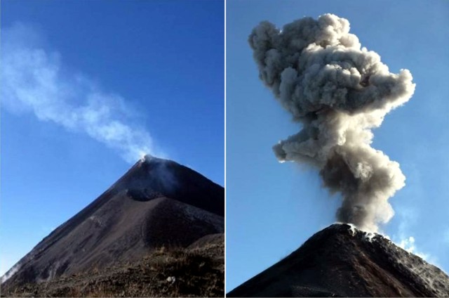 |
Figure 11. Passive degassing (left) and an explosion (right) at Fuego, December 2008-January 2009. From Nadeau and Dalton (2009). |
During 9-21 January 2009, the UV camera was placed on Meseta ~1 km from the erupting vent (figures 12 and 13). An array seismo-acoustic stations was also deployed around the circumference of the vent for full azimuthal coverage. Thick clouds prohibited visibility on most days, resulting in collection of imagery on only 3 dates (12, 14, and 21 January). On 21 January several stationary mini-DOAS (differential optical absorption spectroscopy) scans of the passively degassed plume were also made for comparison with SO2 retrievals from camera images.
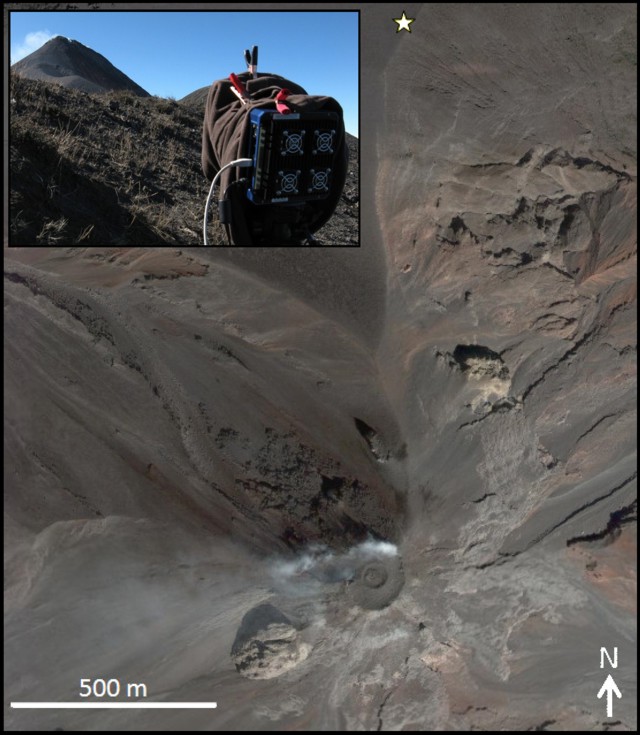 |
Figure 12. Vertical aerial photo the Fuego summit (steaming, near the bottom) and Meseta edifice. Star indicates location of UV camera during field measurements. (inset) UV camera and plume as seen from measurement site. From Nadeau and Dalton (2009). |
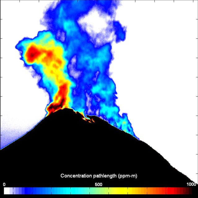 |
Figure 13. A map of SO2 concentration-pathlength created from UV imagery of Fuego during the 2009 campaign. Scale bar at bottom indicates concentration pathlength in colored versions (in units of ppm-m with highest values on the scale and in portions of the plume at ~1,000 ppm-m). From Nadeau and Dalton (2009). |
Preliminary evaluation of camera-derived emissions at Fuego in January 2009 show decreases in SO2 output prior to explosive events, and may indicate short-term sealing of the vent. Additionally, some small low-frequency seismic events without explosion signals in the acoustic record were associated with short-term increases in SO2 output.
A paper presented by Lyons, Waite, and Rose (2009) suggests the potential to track activity of Fuego volcano using explosive energy partitioning. This has implications for monitoring and hazard prediction.
References. Nadeau, P., and Dalton, M., 2009, Report on UV camera field campaign, Fuego and Santiaguito volcanoes, Guatemala, December 2008-January 2009, unpublished informal report accessed January 2010 (URL: http://www.geo.mtu.edu/~panadeau/)
Lyons, J.J., Waite, G.P., and Rose, W.I., 2009, Variable explosive energy partitioning during open vent activity at Fuego volcano, Guatemala 2007-2009: Constraining explosion source processes and implications for monitoring, American Geophysical Union 2009 Fall Meeting Abstract V23D-2124.
Geological Summary. Volcán Fuego, one of Central America's most active volcanoes, is also one of three large stratovolcanoes overlooking Guatemala's former capital, Antigua. The scarp of an older edifice, Meseta, lies between Fuego and Acatenango to the north. Construction of Meseta dates back to about 230,000 years and continued until the late Pleistocene or early Holocene. Collapse of Meseta may have produced the massive Escuintla debris-avalanche deposit, which extends about 50 km onto the Pacific coastal plain. Growth of the modern Fuego volcano followed, continuing the southward migration of volcanism that began at the mostly andesitic Acatenango. Eruptions at Fuego have become more mafic with time, and most historical activity has produced basaltic rocks. Frequent vigorous eruptions have been recorded since the onset of the Spanish era in 1524, and have produced major ashfalls, along with occasional pyroclastic flows and lava flows.
Information Contacts: Instituto Nacional de Sismologia, Vulcanología, Meteorología e Hidrologia (INSIVUMEH) (National Institute of Seismology, Volcanology, Meteorology and Hydrology), Ministero de Communicaciones, Transporto, Obras Públicas y Vivienda, 7a. Av. 14-57, zona 13, Guatemala City 01013, Guatemala (URL: http://www.insivumeh.gob.gt/); Washington Volcanic Ash Advisory Center (VAAC) (URL: http://www.ospo.noaa.gov/Products/atmosphere/vaac/); MODIS/MODVOLC Thermal Alerts, Hawai'i Institute of Geophysics and Planetology (HIGP) Thermal Alerts System, School of Ocean and Earth Science and Technology (SOEST), Univ. of Hawai'i, 2525 Correa Road, Honolulu, HI 96822, USA (URL: http://modis.higp.hawaii.edu/); Gregory Waite, John Lyons, Patricia Nadeau, Marike Dalton, and Joshua Richardson, Michigan Technological University, Department of Geological and Mining Engineering and Science, Houghton, MI, USA (URL: http://www.geo.mtu.edu/rs4hazards/); Kyle Brill, Jemile Erdem, and Jesse Silverman, PCMI (Peace Corps, Master's International Program), Michigan Technological University; Amilcar Cardenas (INSIVUMEH).