Report on Telica (Nicaragua) — March 2010

Bulletin of the Global Volcanism Network, vol. 35, no. 3 (March 2010)
Managing Editor: Richard Wunderman.
Telica (Nicaragua) Incandescent crater floor areas seen in November 2009 and March 2010
Please cite this report as:
Global Volcanism Program, 2010. Report on Telica (Nicaragua) (Wunderman, R., ed.). Bulletin of the Global Volcanism Network, 35:3. Smithsonian Institution. https://doi.org/10.5479/si.GVP.BGVN201003-344040
Telica
Nicaragua
12.606°N, 86.84°W; summit elev. 1036 m
All times are local (unless otherwise noted)
Telica exhibited extensive degassing and sporadic ash explosions during 2006-2008 (BGVN 34:08). Activity since then had decreased to a relatively low level, but degassing was continuing. This report discusses activity in 2009 and January-February 2010 based on reports from the Instituto Nicarag?ense de Estudios Territoriales (INETER) and from fieldwork by Mel Rodgers (University of South Florida) in November 2009 and March 2010.
INETER publishes a monthly bulletin on earthquakes and volcanic activity in Nicaragua. For Telica, most of the monthly data consists of in-field temperature measurements. An observation camera situated 20 km from the crater has not been functional for more than a year. The seismic instrument at Telica was frequently out of order during 2009.
On 20 May 2009, the sulfur dioxide output in the crater ranged from 106-251 tons per day. The maximum temperature of the crater was about 90-112°C in April and May 2009, but rose to 201°C in July, 251°C in August, and 302-317°C during September through November 2009. The maximum temperature of four fumaroles was also measured, which generally ranged from 67-72°C. These temperatures decreased in June 2009 and increased in August 2009 (to 76-105°C). The temperature of fumarole 4 decreased to 59°C in October; gas emission at that fumarole ceased altogether in November.
Visits in November 2009 and March 2010. Mel Rodgers detailed observations during fieldwork at the volcano in November 2009 and March 2010 conducted with Diana Roman (University of South Florida), Peter La Femina and Halldor Geirsson (Pennsylvania State University), and Alain Morales (INETER). On 24-25 November 2009, the group observed a set of elongated fractures flanking the crater floor through which incandescence and/or lava were clearly visible. A high concentration of gas and a steady gas-and-vapor plume were also observed in the crater. Multiple vigorous fumaroles were observed on the W side of the crater close to the top of the crater wall, and an intermittent jetting noise that appeared to be coming from the crater floor was audible from their position at the crater rim. A broadband seismometer was installed and, during the 24-hour visit, a high rate of long-period (LP) seismicity was recorded.
On 15 March 2010, the researchers returned and again observed incandescence within the crater. Incandescence was clearly visible through a C-shaped crack or skylight, SE of the 25 November 2009 location (figures 17 and 18). A high concentration of gas and a steady gas-and-vapor plume in the crater continued and vigorous degassing of the fumaroles on the crater floor was observed (figure 19). Intermittent jetting noises and rockfalls were audible coming from the crater, and at 2202 UTC a loud, low popping noise from the crater was heard. Data retrieved from the single station installed in November 2009 showed a high rate of LP seismicity from November 2009-March 2010.
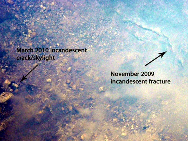 |
Figure 17. Photograph taken 25 November 2009 of Telica volcano showing the relative locations of the 25 November 2009 incandescent fracture (right) and the later 15 March 2010 incandescent crack/skylight (left). Courtesy of Mel Rodgers. |
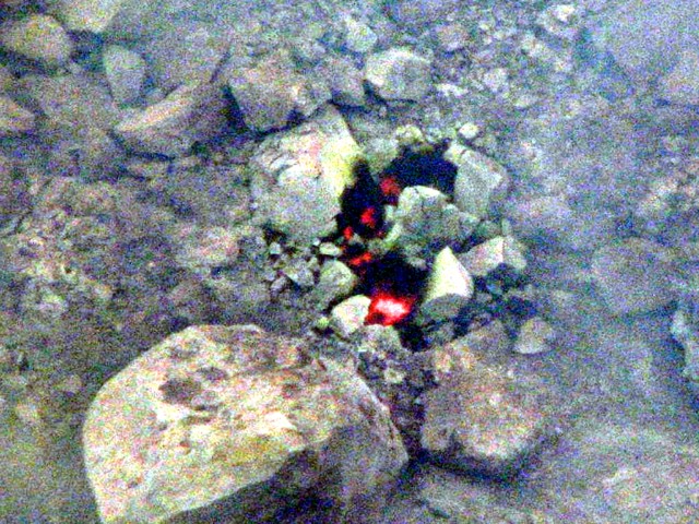 |
Figure 18. Photograph taken 15 March 2010 showing incandescence visible in the C-shaped crack/skylight at Telica volcano. Courtesy of Mel Rodgers. |
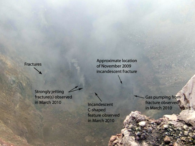 |
Figure 19. Photograph taken 15 March 2010 showing a view of the entire Telica crater floor. Locations of sightings of incandescence and of vigorous gas jets are indicated. Courtesy of Mel Rodgers. |
A successful installation of the TESAND (Telica Seismic and Deformation) network was completed in March 2010. This network, consisting of six broadband seismometers and eight high-rate (1 Hz) continuous global positioning system stations, will be deployed for 3 years to document background LP seismicity and magmatic processes associated with quiescent volcanism.
According to the Hawai'i Institute of Geophysics and Planetology (HIGP) Thermal Alerts System, no satellite thermal alerts were measured over Telica during 2008, 2009, and through 30 April 2010.
Geological Summary. Telica, one of Nicaragua's most active volcanoes, has erupted frequently since the beginning of the Spanish era. This volcano group consists of several interlocking cones and vents with a general NW alignment. Sixteenth-century eruptions were reported at symmetrical Santa Clara volcano at the SW end of the group. However, its eroded and breached crater has been covered by forests throughout historical time, and these eruptions may have originated from Telica, whose upper slopes in contrast are unvegetated. The steep-sided cone of Telica is truncated by a 700-m-wide double crater; the southern crater, the source of recent eruptions, is 120 m deep. El Liston, immediately E, has several nested craters. The fumaroles and boiling mudpots of Hervideros de San Jacinto, SE of Telica, form a prominent geothermal area frequented by tourists, and geothermal exploration has occurred nearby.
Information Contacts: Instituto Nicaraguense de Estudios Territoriales (INETER), Apartado Postal 2110, Managua, Nicaragua; Mel Rodgers, University of South Florida; Hawai'i Institute of Geophysics and Planetology (HIGP) Thermal Alerts System, School of Ocean and Earth Science and Technology (SOEST), Univ. of Hawai'i, 2525 Correa Road, Honolulu, HI 96822 (URL: http://modis.higp.hawaii.edu/).