Report on Nyiragongo (DR Congo) — April 2010

Bulletin of the Global Volcanism Network, vol. 35, no. 4 (April 2010)
Managing Editor: Edward Venzke.
Edited by Jen Fela.
Nyiragongo (DR Congo) Lava fountaining, gas plumes, and tremor during January-May 2009
Please cite this report as:
Global Volcanism Program, 2010. Report on Nyiragongo (DR Congo) (Fela, J., and Venzke, E., eds.). Bulletin of the Global Volcanism Network, 35:4. Smithsonian Institution. https://doi.org/10.5479/si.GVP.BGVN201004-223030
Nyiragongo
DR Congo
1.52°S, 29.25°E; summit elev. 3470 m
All times are local (unless otherwise noted)
The last major eruption from Nyiragongo, in January 2002, sent lava flows into the city of Goma (BGVN 26:12). Prior to that eruption the status of the lava lake in the summit crater, active almost continuously since 1894, had been uncertain. However, fieldworkers in mid-May 2002 noted lava fountaining on the crater floor (BGVN 27:05), and the lava lake has been active since that time. Our most recent report on Nyiragongo in January 2009 (BGVN 34:01) discussed the persistent lava lake, which at the time was visually observed to be rising.
This report is an abridgment of three separate reports to the Governor of the North Kivu Province of Democratic Republic of the Congo which were produced by the Goma Volcano Observatory (GVO). These reports cover January-March, 1-15 April, and 16 April-5 May 2009. Direct observations of the summit crater and the S-flank Shaheru crater, were also carried out in late March.
Seismicity. During January through 5 May, volcanic earthquake swarms and intermittent volcanic tremors were observed at the Bulengo and Rusayo stations (figure 39). Earthquakes generated high-amplitude tremor in March and April, as recorded at the Rusayu seismic station (figure 40). Approximately 80-190 long-period seismic events were recorded daily at the Rusayu station between January and April 2009. Long-period seismicity, which prevailed at the beginning of April, declined toward the end of the month, when long-duration tremor appeared.
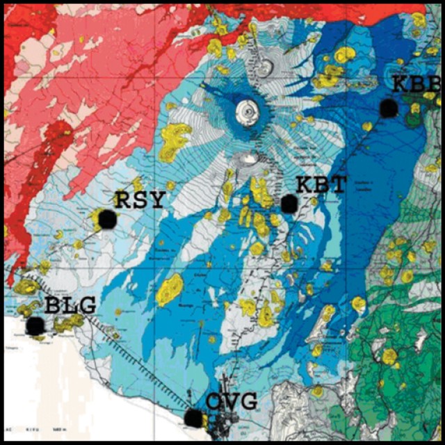 |
Figure 39. Geologic map of the Nyiragongo area, with historical lava flows (shaded blue). Lava flows from Nyamurgira are shown to the NW (shaded red). Six seismic stations are shown: Katale (KTL), Rusayo (RSY), Kibumba (KBB), Kibati (KBT), Bulengo (BLG), and Goma (OVG). Courtesy of Tedesco and others (2007). |
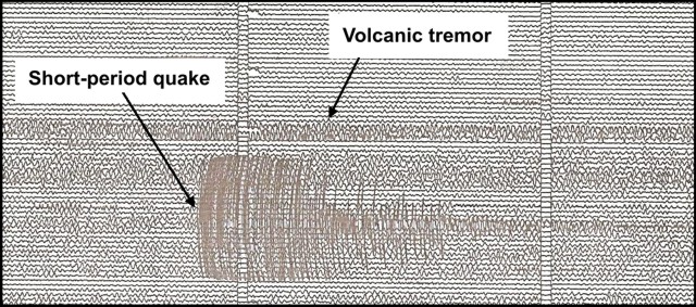 |
Figure 40. Example of volcanic tremor and a short-period earthquake recorded at Rusayu Station on 19 April 2009. Courtesy of GVO. |
During 1 April-5 May, five seismic stations were operational: Bulengo, Goma, Kibumba, Luboga, and Rusayu. Volcanic activity remained very intense (figure 41) and was characterized by long-period earthquakes (average of 140 per day). Several swarms were registered at Bulengo and at Kibumba. Intense activity was recorded at the Bulengo station during 16 April-5 May included tremor that lasted for days. At the Rusayu station, bands of tremors and short-period seismic events (tectonic-volcanic seismic events) were recorded. Short duration (seismic-tectonic) events were observed at the Luboga station, situated N of the Virunga region, which produced a 5.2-magnitude seismic event in October 2008.
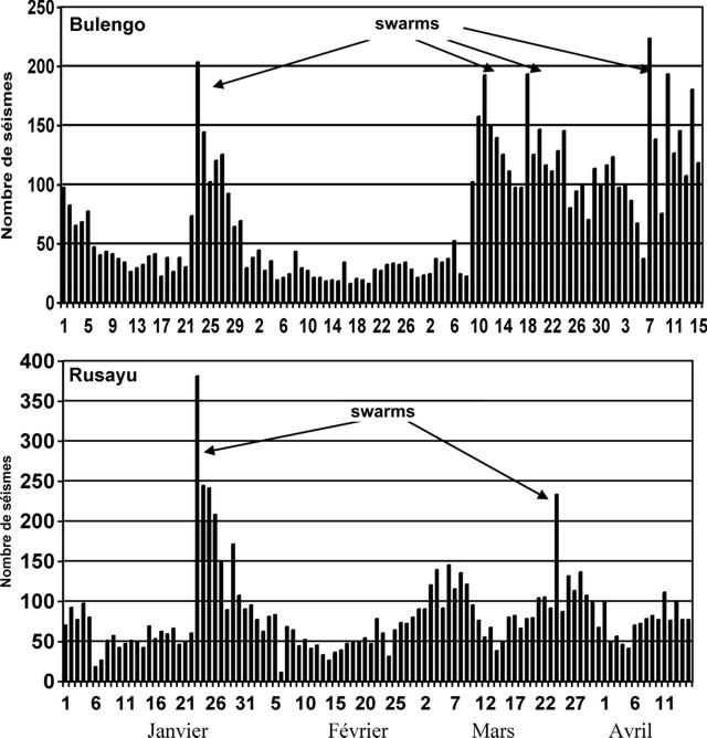 |
Figure 41. Long-period volcanic seismicity recorded S of Nyiragongo at the Bulengo (top) and Rusaya (bottom) stations, 1 January-15 April 2009. The increased swarms recorded at Bulengo in March and April may have been due to activity below Nyamuragira. Courtesy of the GVO. |
Lava lake. Activity in the lava lake during January-March 2009 was characterized by large lava fountains, gas emissions, and ejections of scoria and Pele's hair. In late March, observers noted that the lake level had dropped by ~ 20 m since 27 February, and it remained 600 m below the summit through the rest of the reporting period. Typically the lake remained crusted over in its depression (figure 42), but significant lava fountaining occurred that was consistent with the night glow that was observed at times. Fountaining during 1-15 April increased in intensity along with the incandescence at the summit. Observers during 16 April-5 May noted that the lava lake overflowed from the current pit at several points along the NW and SW rims, and lava fountaining continued.
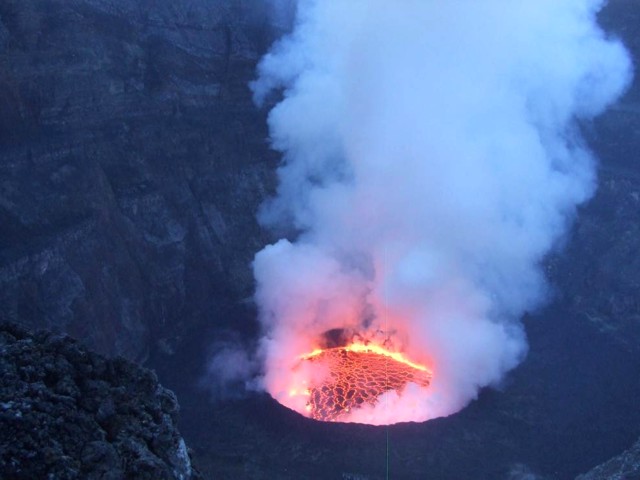 |
Figure 42. Photo of the active lava lake in the summit crater of Nyiragongo, 22 March 2009. Courtesy of the GVO. |
Gas plume. During January-March a large, almost permanent, gas plume above the volcano mixed with atmospheric clouds to produce acid rain that fell on nearby inhabited zones. On 1 April 2009, the gas plume changed direction toward the E (figure 43) and then toward the SE, while normally it blows W. The plume later became denser and at times appeared very black. Also visible at this time was the reflection of the lava fountains on the gas plume above the crater. The dense plume caused by the lava fountaining in the crater continued through 5 May (figure 44).
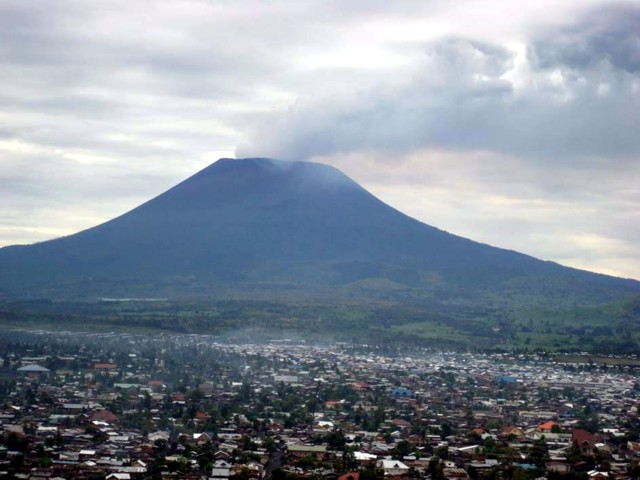 |
Figure 43. Large gas plume blowing E from the summit of Nyiragongo, 1 April 2009, as seen from Goma. Courtesy of the GVO. |
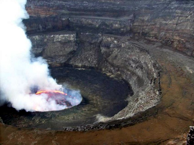 |
Figure 44. Gas plume rising from the active lava lake in the summit crater of Nyiragongo sometime during 16 April-5 May 2009. Courtesy of the GVO. |
Additional observations. During the reporting period, observers noted that the edges of the crater were becoming more unstable. During late March, some collapse of material was seen toward the E part of the crater, and during 16 April-5 May collapse was reported to the SW. A team of scientists from the Goma Volcano Observatory conducted fieldwork from 22 to 24 March 2009.
Measurements at the summit taken on 27 March 2009 revealed a dilation (extension) of approximately 1 mm relative to October 2008. The Mugara fissure underwent a slight compression since that time. Additional measurements through 5 May showed no more than a 0.02 mm change.
Significant fumarolic activity was observed at the S-flank Shaheru crater on 24 March, along the fissures linking Shaheru to the central crater. Shaheru is one of three cones that make up the volcanic complex; the other cones are Baruta and Nyiragongo Central. During 16 April-5 May intermittent but abundant fumaroles along the length of the Shaheru fissure were observed. Also during this period, despite bad weather which obscured visibility, fumarolic columns were observed from the summit.
References. Tedesco, D., Badiali, L., Boschi, E., Papale, P., Tassi, F., Vaselli, O., Kasereka, C., Durieux, J., Denatale, G., Amato, A., Cattaneo, M., Ciraba, H., Chirico, G., Delladio, A., Demartin, M., Favalli, G., Franceschi, D., Lauciani, V., Mavonga, G., Onachesi, G., Pagliuca, N.M., Sorrentino, D., and Yalire, M., 2007, Cooperation on Congo Volcanic and Environmental Risks, Eos, Transactions, American Geophysical Union, v. 88, no. 16, p. 177, 181.
Geological Summary. The Nyiragongo stratovolcano contained a lava lake in its deep summit crater that was active for half a century before draining catastrophically through its outer flanks in 1977. The steep slopes contrast to the low profile of its neighboring shield volcano, Nyamuragira. Benches in the steep-walled, 1.2-km-wide summit crater mark levels of former lava lakes, which have been observed since the late-19th century. Two older stratovolcanoes, Baruta and Shaheru, are partially overlapped by Nyiragongo on the north and south. About 100 cones are located primarily along radial fissures south of Shaheru, east of the summit, and along a NE-SW zone extending as far as Lake Kivu. Many cones are buried by voluminous lava flows that extend long distances down the flanks, which is characterized by the eruption of foiditic rocks. The extremely fluid 1977 lava flows caused many fatalities, as did lava flows that inundated portions of the major city of Goma in January 2002.
Information Contacts: Dieudonné Wafula Mifundu and Célestin Kasereka Mahinda, Observatoire Volcanologique de Goma, Departement de Geophysique, Centre de Recherche en Sciences Naturelles, Lwiro, D.S. Bukavu, DR Congo.