Report on Colima (Mexico) — May 2010

Bulletin of the Global Volcanism Network, vol. 35, no. 5 (May 2010)
Managing Editor: Richard Wunderman.
Colima (Mexico) Dome sheds debris beyond the crater both to the S and from a new lobe to the W
Please cite this report as:
Global Volcanism Program, 2010. Report on Colima (Mexico) (Wunderman, R., ed.). Bulletin of the Global Volcanism Network, 35:5. Smithsonian Institution. https://doi.org/10.5479/si.GVP.BGVN201005-341040
Colima
Mexico
19.514°N, 103.62°W; summit elev. 3850 m
All times are local (unless otherwise noted)
The current lava dome in Colima's crater, first observed around early February 2007 (BGVN 32:10 and 33:04), continued slow growth through March 2010, as reported by Vyacheslav Zobin of the Observatorio Vulcanológico de la Universidad de Colima. As previously noted (BGVN 33:04), in March 2009 the dome had a volume of ~ 1,400,000 m3, about 80% of the total crater volume. The mean effusion rate had stood at ~ 0.03 m3/s in October 2007 (BGVN 34:04). The growth rate slowed further during 2009 and through March 2010 to ~ 0.02 m3/s.
In fall 2009, the new dome growth reached the western rim of the crater. Claus Siebe (UNAM) sent us a photo taken during an overflight on 7 February 2010, showing the lava dome (figure 93). As expected, based on the lack of barrier on the dome's W side, rockfalls became prominent in February 2010 (figure 94).
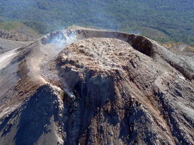 |
Figure 93. Aerial photo of Colima's lava dome taken looking from W to E at 1030 on 7 February 2010. Courtesy of Claus Siebe. |
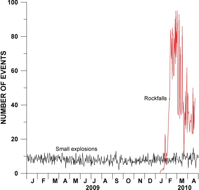 |
Figure 94. Variations in the daily number of small explosions and rockfalls at Colima during 2009 and 2010, obtained from seismic station EZV4, 1.7 km from the crater. Note the increase in the number of rockfalls starting in January-February 2010. Courtesy of Observatorio Vulcanológico de la Universidad de Colima. |
The rockfalls began after heavy rains and the emergence of a small new lobe of lava in the W sector. That lobe had perched on the dome's margin, traversed across the buried crater rim, and began descent down the outer flank (figures 95 and 96). Figure 96 shows the new western lobe in an aerial view. That lobe was ~ 50 m long by March 2010.
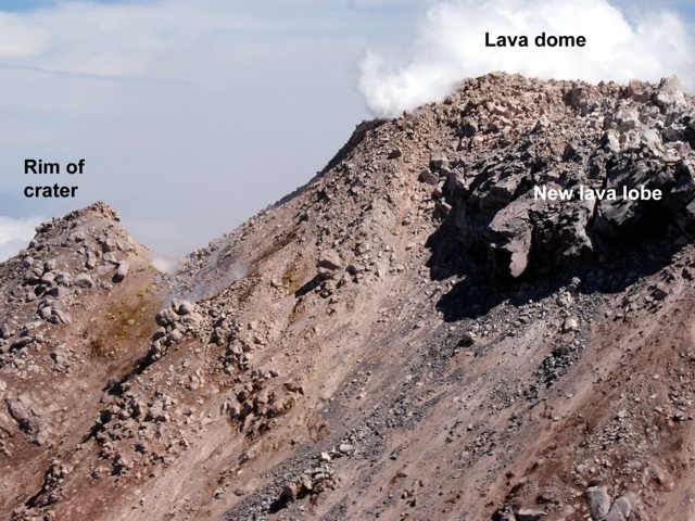 |
Figure 95. A 24 February 2010 photo showing lava dome and new lava lobe at Colima. Courtesy of Civil Protection of Jalisco state. |
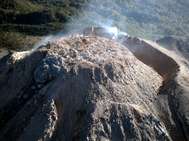 |
Figure 96. View of dome on 29 March 2010 showing Colima's western lobe (left) and the overspilling of the crater to the S (right). Courtesy of Faculty of Science, Colima University. |
Ash plumes rising to ~ 4 km altitude were observed during 24 July-4 August, 22 October, and 1-2 December 2009. On 2 December incandescent tephra was also ejected 50 m above crater to the SE. Seismic data indicated that small explosions continued through April 2010 (figure 94).
Geological Summary. The Colima complex is the most prominent volcanic center of the western Mexican Volcanic Belt. It consists of two southward-younging volcanoes, Nevado de Colima (the high point of the complex) on the north and the historically active Volcán de Colima at the south. A group of late-Pleistocene cinder cones is located on the floor of the Colima graben west and east of the complex. Volcán de Colima (also known as Volcán Fuego) is a youthful stratovolcano constructed within a 5-km-wide scarp, breached to the south, that has been the source of large debris avalanches. Major slope failures have occurred repeatedly from both the Nevado and Colima cones, producing thick debris-avalanche deposits on three sides of the complex. Frequent recorded eruptions date back to the 16th century. Occasional major explosive eruptions have destroyed the summit (most recently in 1913) and left a deep, steep-sided crater that was slowly refilled and then overtopped by lava dome growth.
Information Contacts: Vyacheslav Zobin, Observatorio Vulcanológico de la Universidad de Colima, Colima, Col., 28045, México (URL: https://portal.ucol.mx/cueiv/); Claus Siebe, Instituto de Geofísica UNAM, Ciudad Universitaria, Delegación Coyoacán, C.P. México D.F 04510 (URL: http://www.geofisica.unam.mx/); Gobierno del Estado de Colima (URL: http://www.colima-estado.gob.mx/seguridad/indvolcan.php).