Report on Semeru (Indonesia) — August 2010
Bulletin of the Global Volcanism Network, vol. 35, no. 8 (August 2010)
Managing Editor: Richard Wunderman.
Edited by Jen Fela.
Semeru (Indonesia) Incandescent rock avalanches travel 750 m, plumes reach 500 m above crater
Please cite this report as:
Global Volcanism Program, 2010. Report on Semeru (Indonesia) (Fela, J., and Wunderman, R., eds.). Bulletin of the Global Volcanism Network, 35:8. Smithsonian Institution. https://doi.org/10.5479/si.GVP.BGVN201008-263300
Semeru
Indonesia
8.108°S, 112.922°E; summit elev. 3657 m
All times are local (unless otherwise noted)
Continuing eruptions at Semeru through March 2009 included ash plumes and some pyroclastic flows (BGVN 34:05). The Center of Volcanology and Geological Hazard Mitigation (CVGHM) reported in late July 2009 that ash eruptions had gradually ceased and seismicity had decreased. Seismicity increased again during November 2009 through at least February 2010 (table 19).
Table 19. Types and numbers of earthquakes and plumes observed at Semeru during January 2009-February 2010. Courtesy of CVGHM.
| Month | Harmonic tremor | Explosion earthquakes | Deep volcanic | Shallow volcanic | Observed plumes | Height above crater |
| Jun 2009 | See text | See text | -- | -- | -- | -- |
| Nov 2009 | 98 | 3347 | 2 | -- | 95 | 50-500 m |
| Dec 2009 | 148 | 3507 | 1 | -- | 117 | 100-200 m |
| Jan 2010 | 313 | 2693 | 10 | 1 | 6 | 50-200 m |
| Feb 2010 | 289 | 2522 | 16 | 4 | 41 | 50-200 m |
Regarding tremor and explosion eruptions in June 2009 (table 19), there were fewer than 15 eruptive earthquakes/tremor events per day. The average during May and June 2009 was much less than average daily number of earthquakes during January 2009.
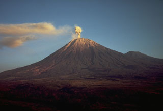
CVGHM reported that, although inclement weather often prevented visual observations, "smoke" was seen rising 50-500 m above the Jonggring Seloko crater through February 2010. On 5 January 2010 incandescence was observed. During 25-28 February, incandescent rock avalanches traveled as far as 750 m from the crater.
MODVOLC Thermal Alerts. According to MODVOLC data, intermittent thermal alerts have been observed for years near Semeru. During this reporting period (April 2009 through October 2010), multiple hotspots were observed only in 2010, on 20 February, 29 April, 2, 20, and 25 May, 14, 21, and 30 June, 7, 28, and 30 July, 6, 8, 15, and 31 August, and 7 and 30 September.
Geological Summary. Semeru, the highest volcano on Java, and one of its most active, lies at the southern end of a volcanic massif extending north to the Tengger caldera. The steep-sided volcano, also referred to as Mahameru (Great Mountain), rises above coastal plains to the south. Gunung Semeru was constructed south of the overlapping Ajek-ajek and Jambangan calderas. A line of lake-filled maars was constructed along a N-S trend cutting through the summit, and cinder cones and lava domes occupy the eastern and NE flanks. Summit topography is complicated by the shifting of craters from NW to SE. Frequent 19th and 20th century eruptions were dominated by small-to-moderate explosions from the summit crater, with occasional lava flows and larger explosive eruptions accompanied by pyroclastic flows that have reached the lower flanks of the volcano.
Information Contacts: Center of Volcanology and Geological Hazard Mitigation (CVGHM), Jalan Diponegoro 57, Bandung 40122, Indonesia (URL: http://vsi.esdm.go.id/); Hawai'i Institute of Geophysics and Planetology (HIGP)Thermal Alerts System, School of Ocean and Earth Science and Technology (SOEST), Univ. of Hawai'i, 2525 Correa Road, Honolulu, HI 96822, USA (URL: http://modis.higp.hawaii.edu/).

