Report on Changbaishan (China-North Korea) — August 2010
Bulletin of the Global Volcanism Network, vol. 35, no. 8 (August 2010)
Managing Editor: Richard Wunderman.
Changbaishan (China-North Korea) Seismicity, deformation, and helium anomalies during 2003-2010
Please cite this report as:
Global Volcanism Program, 2010. Report on Changbaishan (China-North Korea) (Wunderman, R., ed.). Bulletin of the Global Volcanism Network, 35:8. Smithsonian Institution. https://doi.org/10.5479/si.GVP.BGVN201008-305060
Changbaishan
China-North Korea
41.98°N, 128.08°E; summit elev. 2744 m
All times are local (unless otherwise noted)
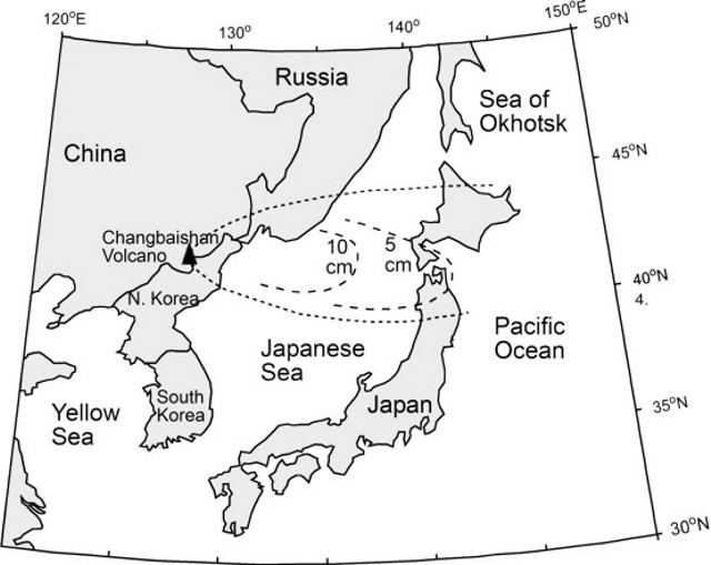
A recent article in Science (Stone, 2010) discussed possible signs of seismic unrest at Changbaishan volcano, on the border between China and North Korea (figure 1). The volcano has numerous synonyms, including Baegdu, Paedu, P'aektu-san (Korean), Baekdoosan, Baitoushan, Chang-pai-shan, Hakuto, and Tiachi (Chinese). Its last recorded explosive eruption occurred in April 1903.
 |
Figure 1. Changbaishan tephra blanket (envalope and thickness) related to the ~1,000 CE eruption. Revised by Zou and others (2010) after Machida and Arai (1983). |
According to the article, in June 2010 a South Korean geologist announced that Changbaishan showed signs of activity. North Korean scientists were concerned about recent geophysical anomalies observed at their monitoring stations. Stone (2010) quoted Chinese volcanologists as saying they have a "sophisticated monitoring system set up at Changbai" but that they "discount the threat and insist that the volcano is quiet." A meeting between South Korea, China, and Japan is planned in November 2010 to study this issue and to address the question of data sharing.
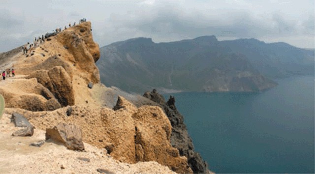
The article also noted that an eruption of Changbaishan could have devastating consequences. Xu Jiandong, director of the China Earthquake Administration (CEA) Active Volcano Research Center in Beijing, was quoted as stating that, of China's 14 active volcanoes, "Changbai poses the biggest hazard." Part of the risk is the threat of lahars from the huge lake in the 5-km-wide caldera (Lake Tianchi - Sky Lake). About 100,000 people live on or near the slopes, with the addition of many tourists in summer (figure 2).
 |
Figure 2. Tourists peer over the rim of the Tianchi caldera at Changbaishan. Courtesy of Stone (2010). |
Xu noted that "In quiet periods, seismometers register about 100 small tremors a year around the mountain. In 2003, Changbaishan Tianchi Volcano Observatory [on the N slope] recorded 1,293 tremors. By 2006, the frequency had receded to background rate, and in the first 6 months of 2010 the station recorded 58 tremors. The mountain rose about 6.8 centimeters in 2003 and 2004, and the ratio of helium-3 [3He] to helium-4 [4He]—'a good indication of magma activity because the source is the mantle'—nearly doubled during that time."
The article noted that the CEA has proposed a major upgrade of its Tianchi caldera monitoring network to begin next year.
References. Horn, S., and Schmincke, H., 2000, Volatile emission during the eruption of Baitoushan volcano (China/North Korea) ca. 969 AD, Bulletin of Volcanology, v. 61, pp. 537-555.
Machida, H., and Arai, F., 1983, Extensive ash falls in and around the Sea of Japan from large late Quaternary eruptions: Journal of Volcanology and Geothermal Research, v. 18, p. 151-164.
Stone, R., 2010, Is China's riskiest volcano stirring or merely biding its time?: Science, v. 329, p. 498-499.
Zou, H., Fan, Q., and Zhang, H., 2010, Rapid development of the great Millennium eruption of Changbaishan (Tianchi) Volcano, China/North Korea: Evidence from U-Th zircon dating: Lithos, v. 119, no. 3-4, p. 289-296.
Geological Summary. Massive Changbaishan stratovolcano (also known as Baitoushan and by the Korean names of Baegdu, Paektu, or P'aektu-san), is located along the China/Korea border. A 5-km-wide, 850-m-deep summit caldera is filled by Lake Tianchi (Sky Lake). The 60-km-diameter dominantly trachytic and rhyolitic volcano was constructed over the Changbaishan (Laoheidingzi) shield volcano. Satellitic cinder cones are aligned along a NNE trend. One of the largest known Holocene explosive eruptions took place here about 946 CE, depositing tephra as far away as northern Japan and forming in part the present caldera; Yang et al. (2021) estimated the total erupted volume to be 40-98 km3. Minor eruptions have been recorded since the 15th century.
Information Contacts: see References.

