Observatory notes high seismicity during mid-2002 to mid-2005
At the 25th General Assembly of the International Union of Geodesy and Geophysics (IUGG), the Chinese National Committee released an overview of data on Chinese volcanoes, especially Changbaishan volcano (figure 3), which they considered the most dangerous and the most likely to erupt (Fan and others, 2011; Liu and others 2011). Focusing on Changbaishan volcano and its summit caldera called Tianchi, Tianchi Volcano Observatory (TVO) released data collected since it formed in 1999. This report will summarize both the TVO's monitoring network and their findings from 1999 to 2010, focusing on the seismic crisis during mid-2002 to mid-2005. As clarification, the name Tianchi is used to refer to the ~ 5 km diameter summit caldera vent of the volcanic complex, and the name Changbaishan is used to refer to the complex in general. The latter name has many synonyms, including Baegdu, Baekdoosan, Baitoushan, Chang-pai-shan, Hakuto, and P'aektu-san.
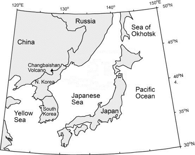 |
Figure 3. Geographic position of Changbaishan volcano, situated on the border between China and North Korea. Adapted from Machida and Arai (1983). |
To continuously monitor seismicity, TVO's Changbaishan volcano center was built in the highlands 40 km from the volcano, and five, two, and four seismic stations were installed within 15, 25, and 50 km of the volcano, respectively. Liu and others (2011) report that TVO's system "can detect M 0.1 volcanic events and give the [detailed] location of M 1.0 and larger volcanic events."
Seismic crisis. Our previous report on Changbaishan briefly discussed an increase in seismicity centered at the volcano in 2003 (BGVN 35:08). Figure 4 and table 1 illustrate that the increased seismicity occurred both in terms of the magnitude and the number of seismic events recorded. A histogram of the annual number of earthquakes from 2002 through 2005 shows a peak in 2003. M 2 and larger earthquakes became common in 2002, and peaked in late 2004. Note that tectonic earthquakes of M 4.4 and 4.0 occurred on 17 December 2004 and 15 April 2005, respectively, and are not related to this trend or Tianchi volcano (Liu and others, 2011). Following the seismic crisis, the number of earthquakes declined slowly, reaching background levels by 2006 (Liu and others, 2011). Liu and others (2011) break the seismic data into three periods over the TVO monitoring history (table 1). As is common with earthquakes at volcanoes around the world, seismic activity at Changbaishan often occurred in swarms, especially from 2002 to 2003, when hundreds of seismic events were sometimes recorded within a single day (figure 4, table 1).
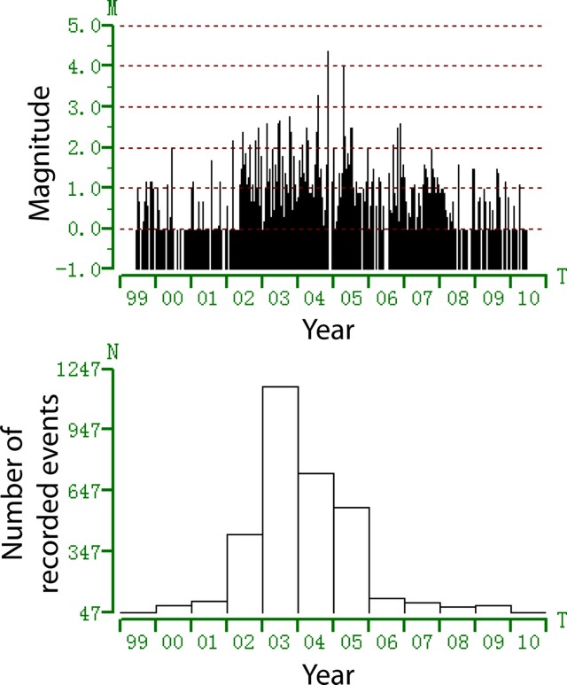 |
Figure 4. Time distribution of seismic events recorded at Tianchi volcano (Changbaishan) from mid-1999 to mid-2010. Top plot indicates magnitude of each seismic event; bottom plot indicates number of seismic events per year. From Liu and others (2011). |
Table 1. Tianchi volcano observatory (TVO) detected three distinct seismic episodes. * = Not including tectonic earthquakes of M 4.4 and 4.0 that occurred on 17 December 2004 and 15 April 2005, respectively. From Liu and others (2011).
| Date Range | Activity | Max. Magnitude | Number of events/time period |
| 1999-Jun 2002 | Background | 1.5 | Under 12/month. |
| Jul 2002-Jul 2005 | Peak (crisis) | 3.7* | Over 100/day, in a series of swarms. |
| Aug 2005-present | Recovery | -- | Under 12/month, generally. |
The hypocenters of earthquakes occurring at Changbaishan, and specifically the Tianchi caldera, were calculated from 2001 to present (figure 5). The majority of the earthquakes originated within 3 km of the Tianchi caldera rim (map distance), and within 5 km depth from the caldera rim.
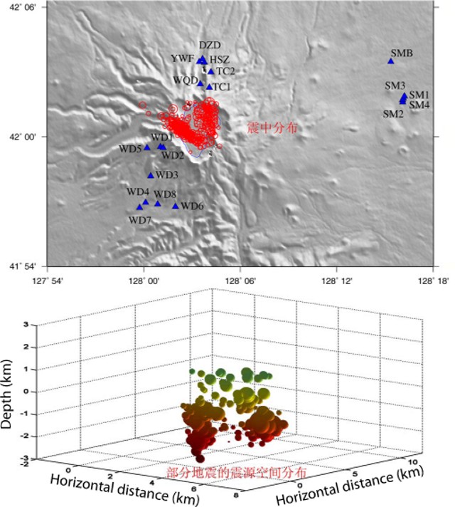 |
Figure 5. Calculated hypocenters for earthquakes occuring at Changbaishan volcano since 2002. (Top) plan-view distribution: triangles are seismic stations, red circles are hypocenters. (Bottom) depth distribution: colors from green to red indicate increasing depth (0 = sea level). Most earthquakes originated directly under the Tianchi caldera, within 5 km of the surface. From Liu and others (2011). |
Coinciding with the increased seismic activity from July 2002 to July 2005, the ground deformation of Changbaishan also entered into a period of inflation, as measured by GPS instruments (figure 6). Horizontal displacement reached a maximum of 4 cm between 2002 and 2003, and continued on a declining trend (figure 6; Liu and others, 2011). Similarly, vertical displacement reached a maximum of 38.6 mm between 2002 and 2003, and declined in the following years; a cumulative vertical displacement of 68.12 mm was measured from 2002 to 2005 (Liu and others, 2011). Vertical displacements of the N and W slopes of the volcano (measured once per year from 2006 to 2009) are presented in table 2.
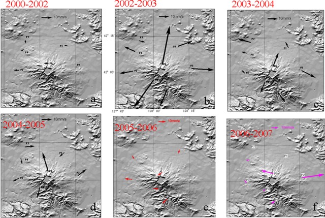 |
Figure 6. Horizontal displacement from GPS surveys from 2000 to 2007, showing inflation at Tianchi caldera of Changbaishan volcano. Reference arrow at the top of each frame is 10 mm/yr. From Liu and others (2011). |
Table 2. Vertical displacement measurements of the N and W slopes of Changbaishan, measured once per year from 2006 through 2009. From Liu and others (2011).
| Year | Slope | Elevation (mm) | Difference from previous year (mm) |
| 2006 | North | 901140.05 | -- |
| 2007 | North | 901148.20 | 8.15 |
| 2008 | North | 901149.26 | 1.06 |
| 2009 | North | 901151.70 | 2.44 |
| 2006 | West | 1084636.20 | -- |
| 2007 | West | 1084661.54 | 25.34 |
| 2008 | West | 1084659.21 | -2.33 |
| 2009 | West | 1084653.77 | -5.44 |
Magma source of Changbaishan. TVO monitored the gas flux of (among others) CO2, N2, He, H2, O2, and CH4, as well as the temperature of hot springs as a supplementary data set. Of particular interest is the measured helium (He) isotopic ratio, 3He/4He. The isotope 3He is often considered primordial. The concentration of 3He on Earth is considered to be essentially stable; the majority of 3He on Earth was trapped upon the formation of the Earth. 4He is a product of the alpha decay of heavy elements in the Earth's crust, and is still produced on Earth by alpha-particle emissions from heavy elements that have differentiated into the Earth's crust and then escape into the atmosphere. The mantle is depleted (relative to the crust and atmosphere) in 4He. 3He/4He ratios (R) of volcanic gases are compared with the common atmospheric 3He/4He ratio (Ra). If volcanic gases provide a particularly high R value (e.g., R = 5, or 5 Ra, indicating values 5 times the atmospheric 3He/4He ratio), then they are considered to be of mantle origin (i.e., depleted in 4He). Liu and others (2011) reported an average 3He/4He value of 5.61 Ra, and concluded that the gases being monitored are mantle sourced.
Liu and others (2011) also reported that He and H2 gas flux increased significantly in 2003 and 2004, associated with the above-mentioned increased volcano-seismicity of July 2002 to July 2005. They also reported He and H2 gas flux increases in October and November 2006, again associated with volcano-seismicity (as well as an M 2.6 tectonic earthquake on 11 November 2006).
From fluid geochemistry measurements, Liu and others (2011) reported that H2S and SO2 fluxes are low but suggested monitoring should increase in the event that the measured values increase.
References. Fan, Q., Sui, J., Zhao, Y., Li, N., and Sun, Q., 2011, Recent progress in active volcanoes in China, in China National Report on Volcanology and Chemistry of the Earth's Interior, for the 25th General Assembly of IUGG, Melbourne, Australia, 28 June-7 July 2011 (prepared by the Chinese National Committee for the International Association of Volcanology and Chemistry of the Earth's Interior (IAVCEI)), pgs. 15-18.
Liu, G., Yang, J., Wang, L., and Sun, J., 2011, The active level analysis of Changbaishan volcano, in China National Report on Volcanology and Chemistry of the Earth's Interior, for the 25th General Assembly of IUGG, Melbourne, Australia, 28 June - 7 July 2011 (prepared by the Chinese National Committee for the International Association of Volcanology and Chemistry of the Earth's Interior (IAVCEI)), pgs. 19-43.
Machida, H., and Arai, F., 1983, Extensive ash falls in and around the Sea of Japan from large late Quaternary eruptions, Journal of Volcanology and Geothermal Research, v. 18, p. 151-164.
Information Contacts: Changbaishan Tianchi Volcano Observatory (TVO), Antu 133613, China.
The Global Volcanism Program has no Weekly Reports available for Changbaishan.
Reports are organized chronologically and indexed below by Month/Year (Publication Volume:Number), and include a one-line summary. Click on the index link or scroll down to read the reports.
Possible gas emissions from summit and hot springs
A news report on 3 November noted that gas emissions from the summit are frequent, many minor volcanic earthquakes have been felt during the last two years, and nearby hot springs were also emitting volcanic gases. The official Xinhua News Agency quoted Ruoxin Liu from the State Seismological Bureau, but we have received no direct confirmation.
Charles Dunlap, Susanne Horn, and Hans Schmincke worked on and around the summit with Chinese geologist Tang Deping during 21-25 July 1993, but saw no emissions. One hot spring area was observed by Dunlap in the N-flank valley, which begins at the lake outlet into the Erdobaihe River. These springs were next to the trail to the waterfall and on up to the lake's edge; eggs were boiled in the spring water for sale to tourists. A weak sulfur smell was detected, but it was not as pronounced as at some springs in Yellowstone or Long Valley (USA). No other emissions were noticed from these springs. Another hot spring location W of this valley was not visited, but apparently it is popular as a bath. On the E border of the crater lake (Korean side), water from a hot spring with a temperature of 700°C was being pumped to the crater rim to provide healing potions.
Baitoushan (Korean name P'aektu-san) is a large stratovolcano on the Korea-Manchurian border ~300 km SE of Changchun and 325 km WSW of Vladivostok, Russia. The 60-km-diameter volcano was constructed over the Changbaishan (Laoheidingz) shield volcano and has a 5-km-wide summit caldera. One of the world's largest known Holocene explosive eruptions took place around 1000 A.D., depositing tephra as far away as N Japan and forming in part the 850-m-deep depression filled by Tianchi Lake. The much better exposed pyroclastic deposits on the North Korean side studied by Horn and Schmincke are extremely thick and include major ignimbrites. Four historical eruptions have been recorded since the 15th century (1413, 1597, 1668, and 1702). Chinese geologists spoken to by Dunlap thought that these historical events were probably phreatic explosions, and that there have possibly been occasional gas emissions within approximately the last 50 years.
Information Contacts: C. Dunlap, University of California - Santa Cruz; S. Horn and H. Schmincke, GEOMAR; Xinhua News Agency, China; UPI.
Seismicity, deformation, and helium anomalies during 2003-2010
A recent article in Science (Stone, 2010) discussed possible signs of seismic unrest at Changbaishan volcano, on the border between China and North Korea (figure 1). The volcano has numerous synonyms, including Baegdu, Paedu, P'aektu-san (Korean), Baekdoosan, Baitoushan, Chang-pai-shan, Hakuto, and Tiachi (Chinese). Its last recorded explosive eruption occurred in April 1903.
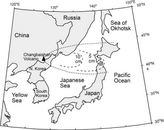 |
Figure 1. Changbaishan tephra blanket (envalope and thickness) related to the ~1,000 CE eruption. Revised by Zou and others (2010) after Machida and Arai (1983). |
According to the article, in June 2010 a South Korean geologist announced that Changbaishan showed signs of activity. North Korean scientists were concerned about recent geophysical anomalies observed at their monitoring stations. Stone (2010) quoted Chinese volcanologists as saying they have a "sophisticated monitoring system set up at Changbai" but that they "discount the threat and insist that the volcano is quiet." A meeting between South Korea, China, and Japan is planned in November 2010 to study this issue and to address the question of data sharing.
The article also noted that an eruption of Changbaishan could have devastating consequences. Xu Jiandong, director of the China Earthquake Administration (CEA) Active Volcano Research Center in Beijing, was quoted as stating that, of China's 14 active volcanoes, "Changbai poses the biggest hazard." Part of the risk is the threat of lahars from the huge lake in the 5-km-wide caldera (Lake Tianchi - Sky Lake). About 100,000 people live on or near the slopes, with the addition of many tourists in summer (figure 2).
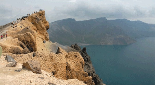 |
Figure 2. Tourists peer over the rim of the Tianchi caldera at Changbaishan. Courtesy of Stone (2010). |
Xu noted that "In quiet periods, seismometers register about 100 small tremors a year around the mountain. In 2003, Changbaishan Tianchi Volcano Observatory [on the N slope] recorded 1,293 tremors. By 2006, the frequency had receded to background rate, and in the first 6 months of 2010 the station recorded 58 tremors. The mountain rose about 6.8 centimeters in 2003 and 2004, and the ratio of helium-3 [3He] to helium-4 [4He]—'a good indication of magma activity because the source is the mantle'—nearly doubled during that time."
The article noted that the CEA has proposed a major upgrade of its Tianchi caldera monitoring network to begin next year.
References. Horn, S., and Schmincke, H., 2000, Volatile emission during the eruption of Baitoushan volcano (China/North Korea) ca. 969 AD, Bulletin of Volcanology, v. 61, pp. 537-555.
Machida, H., and Arai, F., 1983, Extensive ash falls in and around the Sea of Japan from large late Quaternary eruptions: Journal of Volcanology and Geothermal Research, v. 18, p. 151-164.
Stone, R., 2010, Is China's riskiest volcano stirring or merely biding its time?: Science, v. 329, p. 498-499.
Zou, H., Fan, Q., and Zhang, H., 2010, Rapid development of the great Millennium eruption of Changbaishan (Tianchi) Volcano, China/North Korea: Evidence from U-Th zircon dating: Lithos, v. 119, no. 3-4, p. 289-296.
Information Contacts: see References.
Observatory notes high seismicity during mid-2002 to mid-2005
At the 25th General Assembly of the International Union of Geodesy and Geophysics (IUGG), the Chinese National Committee released an overview of data on Chinese volcanoes, especially Changbaishan volcano (figure 3), which they considered the most dangerous and the most likely to erupt (Fan and others, 2011; Liu and others 2011). Focusing on Changbaishan volcano and its summit caldera called Tianchi, Tianchi Volcano Observatory (TVO) released data collected since it formed in 1999. This report will summarize both the TVO's monitoring network and their findings from 1999 to 2010, focusing on the seismic crisis during mid-2002 to mid-2005. As clarification, the name Tianchi is used to refer to the ~ 5 km diameter summit caldera vent of the volcanic complex, and the name Changbaishan is used to refer to the complex in general. The latter name has many synonyms, including Baegdu, Baekdoosan, Baitoushan, Chang-pai-shan, Hakuto, and P'aektu-san.
|
Figure 3. Geographic position of Changbaishan volcano, situated on the border between China and North Korea. Adapted from Machida and Arai (1983). |
To continuously monitor seismicity, TVO's Changbaishan volcano center was built in the highlands 40 km from the volcano, and five, two, and four seismic stations were installed within 15, 25, and 50 km of the volcano, respectively. Liu and others (2011) report that TVO's system "can detect M 0.1 volcanic events and give the [detailed] location of M 1.0 and larger volcanic events."
Seismic crisis. Our previous report on Changbaishan briefly discussed an increase in seismicity centered at the volcano in 2003 (BGVN 35:08). Figure 4 and table 1 illustrate that the increased seismicity occurred both in terms of the magnitude and the number of seismic events recorded. A histogram of the annual number of earthquakes from 2002 through 2005 shows a peak in 2003. M 2 and larger earthquakes became common in 2002, and peaked in late 2004. Note that tectonic earthquakes of M 4.4 and 4.0 occurred on 17 December 2004 and 15 April 2005, respectively, and are not related to this trend or Tianchi volcano (Liu and others, 2011). Following the seismic crisis, the number of earthquakes declined slowly, reaching background levels by 2006 (Liu and others, 2011). Liu and others (2011) break the seismic data into three periods over the TVO monitoring history (table 1). As is common with earthquakes at volcanoes around the world, seismic activity at Changbaishan often occurred in swarms, especially from 2002 to 2003, when hundreds of seismic events were sometimes recorded within a single day (figure 4, table 1).
|
Figure 4. Time distribution of seismic events recorded at Tianchi volcano (Changbaishan) from mid-1999 to mid-2010. Top plot indicates magnitude of each seismic event; bottom plot indicates number of seismic events per year. From Liu and others (2011). |
Table 1. Tianchi volcano observatory (TVO) detected three distinct seismic episodes. * = Not including tectonic earthquakes of M 4.4 and 4.0 that occurred on 17 December 2004 and 15 April 2005, respectively. From Liu and others (2011).
| Date Range | Activity | Max. Magnitude | Number of events/time period |
| 1999-Jun 2002 | Background | 1.5 | Under 12/month. |
| Jul 2002-Jul 2005 | Peak (crisis) | 3.7* | Over 100/day, in a series of swarms. |
| Aug 2005-present | Recovery | -- | Under 12/month, generally. |
The hypocenters of earthquakes occurring at Changbaishan, and specifically the Tianchi caldera, were calculated from 2001 to present (figure 5). The majority of the earthquakes originated within 3 km of the Tianchi caldera rim (map distance), and within 5 km depth from the caldera rim.
|
Figure 5. Calculated hypocenters for earthquakes occuring at Changbaishan volcano since 2002. (Top) plan-view distribution: triangles are seismic stations, red circles are hypocenters. (Bottom) depth distribution: colors from green to red indicate increasing depth (0 = sea level). Most earthquakes originated directly under the Tianchi caldera, within 5 km of the surface. From Liu and others (2011). |
Coinciding with the increased seismic activity from July 2002 to July 2005, the ground deformation of Changbaishan also entered into a period of inflation, as measured by GPS instruments (figure 6). Horizontal displacement reached a maximum of 4 cm between 2002 and 2003, and continued on a declining trend (figure 6; Liu and others, 2011). Similarly, vertical displacement reached a maximum of 38.6 mm between 2002 and 2003, and declined in the following years; a cumulative vertical displacement of 68.12 mm was measured from 2002 to 2005 (Liu and others, 2011). Vertical displacements of the N and W slopes of the volcano (measured once per year from 2006 to 2009) are presented in table 2.
|
Figure 6. Horizontal displacement from GPS surveys from 2000 to 2007, showing inflation at Tianchi caldera of Changbaishan volcano. Reference arrow at the top of each frame is 10 mm/yr. From Liu and others (2011). |
Table 2. Vertical displacement measurements of the N and W slopes of Changbaishan, measured once per year from 2006 through 2009. From Liu and others (2011).
| Year | Slope | Elevation (mm) | Difference from previous year (mm) |
| 2006 | North | 901140.05 | -- |
| 2007 | North | 901148.20 | 8.15 |
| 2008 | North | 901149.26 | 1.06 |
| 2009 | North | 901151.70 | 2.44 |
| 2006 | West | 1084636.20 | -- |
| 2007 | West | 1084661.54 | 25.34 |
| 2008 | West | 1084659.21 | -2.33 |
| 2009 | West | 1084653.77 | -5.44 |
Magma source of Changbaishan. TVO monitored the gas flux of (among others) CO2, N2, He, H2, O2, and CH4, as well as the temperature of hot springs as a supplementary data set. Of particular interest is the measured helium (He) isotopic ratio, 3He/4He. The isotope 3He is often considered primordial. The concentration of 3He on Earth is considered to be essentially stable; the majority of 3He on Earth was trapped upon the formation of the Earth. 4He is a product of the alpha decay of heavy elements in the Earth's crust, and is still produced on Earth by alpha-particle emissions from heavy elements that have differentiated into the Earth's crust and then escape into the atmosphere. The mantle is depleted (relative to the crust and atmosphere) in 4He. 3He/4He ratios (R) of volcanic gases are compared with the common atmospheric 3He/4He ratio (Ra). If volcanic gases provide a particularly high R value (e.g., R = 5, or 5 Ra, indicating values 5 times the atmospheric 3He/4He ratio), then they are considered to be of mantle origin (i.e., depleted in 4He). Liu and others (2011) reported an average 3He/4He value of 5.61 Ra, and concluded that the gases being monitored are mantle sourced.
Liu and others (2011) also reported that He and H2 gas flux increased significantly in 2003 and 2004, associated with the above-mentioned increased volcano-seismicity of July 2002 to July 2005. They also reported He and H2 gas flux increases in October and November 2006, again associated with volcano-seismicity (as well as an M 2.6 tectonic earthquake on 11 November 2006).
From fluid geochemistry measurements, Liu and others (2011) reported that H2S and SO2 fluxes are low but suggested monitoring should increase in the event that the measured values increase.
References. Fan, Q., Sui, J., Zhao, Y., Li, N., and Sun, Q., 2011, Recent progress in active volcanoes in China, in China National Report on Volcanology and Chemistry of the Earth's Interior, for the 25th General Assembly of IUGG, Melbourne, Australia, 28 June-7 July 2011 (prepared by the Chinese National Committee for the International Association of Volcanology and Chemistry of the Earth's Interior (IAVCEI)), pgs. 15-18.
Liu, G., Yang, J., Wang, L., and Sun, J., 2011, The active level analysis of Changbaishan volcano, in China National Report on Volcanology and Chemistry of the Earth's Interior, for the 25th General Assembly of IUGG, Melbourne, Australia, 28 June - 7 July 2011 (prepared by the Chinese National Committee for the International Association of Volcanology and Chemistry of the Earth's Interior (IAVCEI)), pgs. 19-43.
Machida, H., and Arai, F., 1983, Extensive ash falls in and around the Sea of Japan from large late Quaternary eruptions, Journal of Volcanology and Geothermal Research, v. 18, p. 151-164.
Information Contacts: Changbaishan Tianchi Volcano Observatory (TVO), Antu 133613, China.
|
|
||||||||||||||||||||||||||||
There is data available for 7 confirmed eruptive periods.
1903 Apr 15 ± 45 days Confirmed Eruption (Explosive / Effusive)
| Episode 1 | Eruption (Explosive / Effusive) | Liuhaojie tuff ring? | ||||||||||||||||||||||||||||
|---|---|---|---|---|---|---|---|---|---|---|---|---|---|---|---|---|---|---|---|---|---|---|---|---|---|---|---|---|---|
| 1903 Apr 15 ± 45 days - Unknown | Evidence from Observations: Reported | ||||||||||||||||||||||||||||
| Liu and Taniguchi (2001) reported accounts of an eruption in the Spring of 1903 describing a hurricane accompanied with a roaring sound that surged over the forest, a blood red sky, and "fire balls" that soared and danced over the mountain. Sakhno (2007) described a 1903 eruption with rhyolitic pumice and ash. Wei et al. (2013) suggested that the 1903 eruption may have originated from the Liuhaojie tuff ring. | |||||||||||||||||||||||||||||
|
List of 4 Events for Episode 1 at Liuhaojie tuff ring?
|
|||||||||||||||||||||||||||||
1898 Confirmed Eruption (Explosive / Effusive) VEI: 2 (?)
| Episode 1 | Eruption (Explosive / Effusive) | ||||||||||||||||||||||||
|---|---|---|---|---|---|---|---|---|---|---|---|---|---|---|---|---|---|---|---|---|---|---|---|---|
| 1898 - Unknown | Evidence from Observations: Reported | |||||||||||||||||||||||
| The Russian traveler N.M. Garin-Makihailovskii observed a weak phreatomagmatic eruption from the caldera lake (Sakhno, 2007). | ||||||||||||||||||||||||
|
List of 3 Events for Episode 1
|
||||||||||||||||||||||||
1702 Jun 9 Confirmed Eruption (Explosive / Effusive)
| Episode 1 | Eruption (Explosive / Effusive) | Wuhaojie? | ||||||||||||||||||||||||||||
|---|---|---|---|---|---|---|---|---|---|---|---|---|---|---|---|---|---|---|---|---|---|---|---|---|---|---|---|---|---|
| 1702 Jun 9 - Unknown | Evidence from Observations: Reported | ||||||||||||||||||||||||||||
| According to tradition Changbaishan erupted in 1702 CE (Ogura, 1969). Pyroclastic fall and flow deposits and pantelleritic lava flows overlying products of the caldera-forming eruption may have originated during this event (Liu et al., 1992). Liu and Taniguchi (2001) noted that on 9 June 1702 the sky suddenly became dim and an occasional "red-yellow flame" was seen, along with a fishy-smelling odor. In the morning of the 2nd day, dust was scattered over the fields in Xiancheng Prefecture, about 70-140 km E of the volcano. Sakhno (2007) noted ignimbrite flows on the flanks of the volcano and in the caldera. Wei et al. (2013) considered this to be the largest and most likely valid of the reported historical eruptions, and to have possibly produced the Wuhaojie deposits. | |||||||||||||||||||||||||||||
|
List of 4 Events for Episode 1 at Wuhaojie?
|
|||||||||||||||||||||||||||||
1668 Jun Confirmed Eruption (Explosive / Effusive)
| Episode 1 | Eruption (Explosive / Effusive) | Bagumiao ignmibrite and pumice? | ||||||||||||||||||||||||||||
|---|---|---|---|---|---|---|---|---|---|---|---|---|---|---|---|---|---|---|---|---|---|---|---|---|---|---|---|---|---|
| 1668 Jun - Unknown | Evidence from Observations: Reported | ||||||||||||||||||||||||||||
| Reports that dust fell at the same time in Jingcheng and Funing prefectures in April of the 9th year of King Zianzong (June 1668 CE) was attributed to an eruption of Changbaishan (Liu and Taniguchi, 2001). Wei et al. (2013) also suggested that the Bagumiao ignimbrite and pumice may have been from the 1668 event. | |||||||||||||||||||||||||||||
|
List of 4 Events for Episode 1 at Bagumiao ignmibrite and pumice?
|
|||||||||||||||||||||||||||||
[ 1597 Oct 6 ] Uncertain Eruption
| Episode 1 | Uncertain | ||||||||||||||||||||||||
|---|---|---|---|---|---|---|---|---|---|---|---|---|---|---|---|---|---|---|---|---|---|---|---|---|
| 1597 Oct 6 - Unknown | Evidence from Unknown | |||||||||||||||||||||||
| An eruption reportedly took place at the time of a major earthquake on 6 October 1597 CE, with detonations heard and large blocks ejected (Shi et al., 1986). However, Wei et al. (2003) questioned this eruption. | ||||||||||||||||||||||||
|
List of 3 Events for Episode 1
|
||||||||||||||||||||||||
[ 1413 ] Uncertain Eruption
| Episode 1 | Uncertain | ||||
|---|---|---|---|---|
| 1413 - Unknown | Evidence from Unknown | |||
| An eruption in 1413 CE was recorded by Machida et al. (1990), although Wei et al. (2003) questioned it. | ||||
0946 Nov 15 ± 45 days Confirmed Eruption (Explosive / Effusive) VEI: 6
| Episode 1 | Eruption (Explosive / Effusive) | Millennium Eruption | ||||||||||||||||||||||||||||||||||||||||||||||||
|---|---|---|---|---|---|---|---|---|---|---|---|---|---|---|---|---|---|---|---|---|---|---|---|---|---|---|---|---|---|---|---|---|---|---|---|---|---|---|---|---|---|---|---|---|---|---|---|---|---|
| 0946 Nov 15 ± 45 days - Unknown | Evidence from Isotopic: 14C (calibrated) | ||||||||||||||||||||||||||||||||||||||||||||||||
| One of the largest known Holocene explosive eruptions took place about 1,000 years ago and is sometimes referred to as the Millennium Eruption. The eruption deposited more than 150 km3 of pumice (Dunlap et al., 1992) and began with a debris flow to the north, possibly from collapse of the caldera rim, and was followed by Plinian eruptions, pyroclastic flows, and mudflows (Moriwaki et al., 1988; Machida et al., 1990). The prominent Baegdusan-Tomakomai tephra was deposited as far away as northern Japan. A wide variety of radiocarbon dates have been obtained, with some studies using calibrated wiggle-matching dates in association with potential historical evidence, resulting in the eruption being assigned to the winters of 938/939 CE (Yin et al., 2012) or 946-947 CE (Xu et al., 2013). Additional refinement of tree-ring calibrations by Oppenheimer et al. (2017) narrowed the timeframe to the last few months of 946. | |||||||||||||||||||||||||||||||||||||||||||||||||
|
List of 8 Events for Episode 1 at Millennium Eruption
|
|||||||||||||||||||||||||||||||||||||||||||||||||
0180 BCE ± 80 years Confirmed Eruption (Explosive / Effusive) VEI: 4
| Episode 1 | Eruption (Explosive / Effusive) | ||||||||||||||||||||||||
|---|---|---|---|---|---|---|---|---|---|---|---|---|---|---|---|---|---|---|---|---|---|---|---|---|
| 0180 BCE ± 80 years - Unknown | Evidence from Isotopic: 14C (uncalibrated) | |||||||||||||||||||||||
| A tephra layer originating form this volcano with a radiocarbon age of 2,130 ± 80 years BP was found in southern Hokkaido (Horn and Schminke, 2000). Large scale pyroclastic-flow deposits in valleys surrounding Tianchi Lake from this or another eruption are older than 1,140 BP and younger than 5,000 BP (Liu et al., 1992). | ||||||||||||||||||||||||
|
List of 3 Events for Episode 1
|
||||||||||||||||||||||||
[ 1000 BCE (?) ] Uncertain Eruption
| Episode 1 | Uncertain | ||||||||||||||||||||||||
|---|---|---|---|---|---|---|---|---|---|---|---|---|---|---|---|---|---|---|---|---|---|---|---|---|
| 1000 BCE (?) - Unknown | Evidence from Correlation: Anthropology | |||||||||||||||||||||||
| Manchurian lore suggested possible eruptive activity about 1000 BCE (Wei et al., 2003). Sakhno (2007) assigned ignimbrite and "flows" to this event, with deposits 30 m thick. However, Wei et al. (2013) did not recognize this as an eruption. | ||||||||||||||||||||||||
|
List of 3 Events for Episode 1
|
||||||||||||||||||||||||
2155 BCE ± 90 years Confirmed Eruption (Explosive / Effusive) VEI: 4
| Episode 1 | Eruption (Explosive / Effusive) | ||||||||||||||||||||||||
|---|---|---|---|---|---|---|---|---|---|---|---|---|---|---|---|---|---|---|---|---|---|---|---|---|
| 2155 BCE ± 90 years - Unknown | Evidence from Isotopic: 14C (uncalibrated) | |||||||||||||||||||||||
| A major ignimbrite-producing eruption was radiocarbon dated at 4,105 ± 90 BP (Wei et al., 2003). Manchurian lore indicates an eruption about 5,000-4,000 BP. | ||||||||||||||||||||||||
|
List of 3 Events for Episode 1
|
||||||||||||||||||||||||
This compilation of synonyms and subsidiary features may not be comprehensive. Features are organized into four major categories: Cones, Craters, Domes, and Thermal Features. Synonyms of features appear indented below the primary name. In some cases additional feature type, elevation, or location details are provided.
Synonyms |
||||
| Baitoushan | P'aektu-san | Baegdu | Baekdoosan | Hakuto | Chang-Pai-shan | Paektu | Baektu | Baegdu-san | Tianchi | Hakuto-san | ||||
Cones |
||||
| Feature Name | Feature Type | Elevation | Latitude | Longitude |
| Dayanzhifeng
Ta-Yen-Chih-Feng |
Cone | |||
| Laoheidingzi
Lao-Hei-Ting-Tzu |
Shield volcano | |||
| Liuhaojie | Tuff ring | |||
| Xiaoyanzhifeng
Hsiao-Yen-Chih-Feng |
Cone | |||
Craters |
||||
| Feature Name | Feature Type | Elevation | Latitude | Longitude |
| Tianchi
Tien-Chi Ch'on-ji |
Caldera | |||
Thermal |
||||
| Feature Name | Feature Type | Elevation | Latitude | Longitude |
| Chang-Pai | Thermal | |||
| Tang-Shui-Chang | Thermal | |||
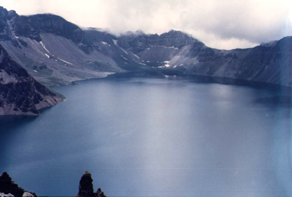
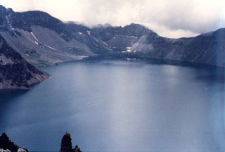 Lake Tianchi occupies the 5-km-wide, 850-m-deep summit caldera of Changbaishan, which straddles the China/Korea border. The volcano is also known as Baitoushan and by the Korean names of Baegdu or P'aektu-san. This view looks from the northern rim on the Chinese side towards the SE caldera wall on the Korean side. One of the world's largest known Holocene explosive eruptions took place from Changbaishan about 1000 CE, depositing tephra as far away as northern Japan.
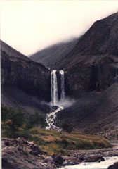 Water draining from Tianchi lake plunges over a mid-Pleistocene trachytic lava flow near the caldera rim on the upper N flank of Changbaishan (Baitoushan) volcano.
There are no samples for Changbaishan in the Smithsonian's NMNH Department of Mineral Sciences Rock and Ore collection.
| Copernicus Browser | The Copernicus Browser replaced the Sentinel Hub Playground browser in 2023, to provide access to Earth observation archives from the Copernicus Data Space Ecosystem, the main distribution platform for data from the EU Copernicus missions. |
| MIROVA | Middle InfraRed Observation of Volcanic Activity (MIROVA) is a near real time volcanic hot-spot detection system based on the analysis of MODIS (Moderate Resolution Imaging Spectroradiometer) data. In particular, MIROVA uses the Middle InfraRed Radiation (MIR), measured over target volcanoes, in order to detect, locate and measure the heat radiation sourced from volcanic activity. |
| MODVOLC Thermal Alerts | Using infrared satellite Moderate Resolution Imaging Spectroradiometer (MODIS) data, scientists at the Hawai'i Institute of Geophysics and Planetology, University of Hawai'i, developed an automated system called MODVOLC to map thermal hot-spots in near real time. For each MODIS image, the algorithm automatically scans each 1 km pixel within it to check for high-temperature hot-spots. When one is found the date, time, location, and intensity are recorded. MODIS looks at every square km of the Earth every 48 hours, once during the day and once during the night, and the presence of two MODIS sensors in space allows at least four hot-spot observations every two days. Each day updated global maps are compiled to display the locations of all hot spots detected in the previous 24 hours. There is a drop-down list with volcano names which allow users to 'zoom-in' and examine the distribution of hot-spots at a variety of spatial scales. |
|
WOVOdat
Single Volcano View Temporal Evolution of Unrest Side by Side Volcanoes |
WOVOdat is a database of volcanic unrest; instrumentally and visually recorded changes in seismicity, ground deformation, gas emission, and other parameters from their normal baselines. It is sponsored by the World Organization of Volcano Observatories (WOVO) and presently hosted at the Earth Observatory of Singapore.
GVMID Data on Volcano Monitoring Infrastructure The Global Volcano Monitoring Infrastructure Database GVMID, is aimed at documenting and improving capabilities of volcano monitoring from the ground and space. GVMID should provide a snapshot and baseline view of the techniques and instrumentation that are in place at various volcanoes, which can be use by volcano observatories as reference to setup new monitoring system or improving networks at a specific volcano. These data will allow identification of what monitoring gaps exist, which can be then targeted by remote sensing infrastructure and future instrument deployments. |
| Volcanic Hazard Maps | The IAVCEI Commission on Volcanic Hazards and Risk has a Volcanic Hazard Maps database designed to serve as a resource for hazard mappers (or other interested parties) to explore how common issues in hazard map development have been addressed at different volcanoes, in different countries, for different hazards, and for different intended audiences. In addition to the comprehensive, searchable Volcanic Hazard Maps Database, this website contains information about diversity of volcanic hazard maps, illustrated using examples from the database. This site is for educational purposes related to volcanic hazard maps. Hazard maps found on this website should not be used for emergency purposes. For the most recent, official hazard map for a particular volcano, please seek out the proper institutional authorities on the matter. |
| IRIS seismic stations/networks | Incorporated Research Institutions for Seismology (IRIS) Data Services map showing the location of seismic stations from all available networks (permanent or temporary) within a radius of 0.18° (about 20 km at mid-latitudes) from the given location of Changbaishan. Users can customize a variety of filters and options in the left panel. Note that if there are no stations are known the map will default to show the entire world with a "No data matched request" error notice. |
| UNAVCO GPS/GNSS stations | Geodetic Data Services map from UNAVCO showing the location of GPS/GNSS stations from all available networks (permanent or temporary) within a radius of 20 km from the given location of Changbaishan. Users can customize the data search based on station or network names, location, and time window. Requires Adobe Flash Player. |
| DECADE Data | The DECADE portal, still in the developmental stage, serves as an example of the proposed interoperability between The Smithsonian Institution's Global Volcanism Program, the Mapping Gas Emissions (MaGa) Database, and the EarthChem Geochemical Portal. The Deep Earth Carbon Degassing (DECADE) initiative seeks to use new and established technologies to determine accurate global fluxes of volcanic CO2 to the atmosphere, but installing CO2 monitoring networks on 20 of the world's 150 most actively degassing volcanoes. The group uses related laboratory-based studies (direct gas sampling and analysis, melt inclusions) to provide new data for direct degassing of deep earth carbon to the atmosphere. |
| Large Eruptions of Changbaishan | Information about large Quaternary eruptions (VEI >= 4) is cataloged in the Large Magnitude Explosive Volcanic Eruptions (LaMEVE) database of the Volcano Global Risk Identification and Analysis Project (VOGRIPA). |
| EarthChem | EarthChem develops and maintains databases, software, and services that support the preservation, discovery, access and analysis of geochemical data, and facilitate their integration with the broad array of other available earth science parameters. EarthChem is operated by a joint team of disciplinary scientists, data scientists, data managers and information technology developers who are part of the NSF-funded data facility Integrated Earth Data Applications (IEDA). IEDA is a collaborative effort of EarthChem and the Marine Geoscience Data System (MGDS). |

