Report on Planchon-Peteroa (Chile) — November 2010
Bulletin of the Global Volcanism Network, vol. 35, no. 11 (November 2010)
Managing Editor: Richard Wunderman.
Planchon-Peteroa (Chile) Small eruptions begin in September 2010 after 12 years of quiet
Please cite this report as:
Global Volcanism Program, 2010. Report on Planchon-Peteroa (Chile) (Wunderman, R., ed.). Bulletin of the Global Volcanism Network, 35:11. Smithsonian Institution. https://doi.org/10.5479/si.GVP.BGVN201011-357040
Planchon-Peteroa
Chile
35.223°S, 70.568°W; summit elev. 3977 m
All times are local (unless otherwise noted)
Explosive eruptions began at Planchón-Peteroa volcano in early September 2010, generating plumes reported to have reached altitudes of over 7 km. From the time of our last report on the volcano in March 2001 (BGVN 26:03) into 2010, we have learned of no significant eruptive activity as reported by Servicio Nacional de Geología y Minería (SERNAGEOMIN - the Chilean National Service of Geology and Mining). On several occasions during this ~9-year period, increased fumarolic activity was reported at Planchón-Peteroa. It was typically described as being normal and likely caused by atmospheric changes that made the plumes more visible from greater distances. This increased visible activity was also reported as being common when snow melts in the crater and more steam is produced. The volcano's previous reported eruption occurred in November 1998 (BGVN 24:03).
Beginning 6 September 2010, the ice-covered volcano erupted in a series of small ash and gas clouds (table 2). SERNAGEOMIN reported that the eruptions were probably phreatomagmatic (caused by the interaction of water with magma at depth inside the volcano). During the day, black pyroclastic eruptions reached altitudes of up to 1.2 km above the crater area, and a plume extended ~30 km to the E and, to a limited extent, to the N and S. Pictures from Romeral (about 61 km NW of the volcano) showed emission of gases and gray ash that rose ~200 m. The same day at 0647, SERNAGEOMIN recorded an M 5.2 earthquake at 13.4 km depth, located ~15 km SE of the volcano. According to SERNAGEOMIN, an overflight on 7 September revealed that the 6 September explosions, during which pulses of gas and ash occurred every 40-60 seconds, were possibly phreato-magmatic in origin and similar to the explosions in 1991. Plumes rose 200 m above the crater and ash mostly fell within 10 km to the E.
Table 2. Ash and gas plumes from Planchón-Peteroa as reported by SERNAGEOMIN (abbreviated SERN in table) and Buenos Aires Volcanic Ash Advisory Center (VAAC) from January-October 2010.
| Date | Plume height (km) | Plume drift | Report source | Comments |
| 04, 06, 07 Jan 2010 | 0.25 | -- | SERN | Fumarolic plume only. |
| 28 Jul 2010 | -- | E | VAAC | Gas plume only. |
| 06 Sep 2010 | 0.2-1.2 | 10-30 km E, N, S | SERN | Phreatomagmatic explosions; pulses of gas and ash every 40-60 sec during the eruption. |
| 10 Sep-13 Sep 2010 | -- | -- | SERN | With time, plumes rising from the vent had progressively less ash and higher concentrations of water vapor; juvenile material absent in ash petrographic and mineralogical studies. |
| 18 Sep 2010 | -- | 22 km SE | NASA Earth Observatory | Eruption intensified; ash on snow under plume. |
| 21 Sep 2010 | 6.1 | SE | VAAC | Ash plume. |
| 26 Sep 2010 | 4.3 | SSE | VAAC | Ash plume. |
| 30 Sep-03 Oct 2010 | 3-6.1 | Multiple directions | VAAC | Strongest emission of the past 3 weeks. Ash plume diffused over wide area of Argentina. |
| 06 Oct-12 Oct 2010 | 4-6.1 | Multiple directions | VAAC | Ash plume. |
| 12 Oct 2010 | 4.6 | E | VAAC | Ash plume. |
During 16-30 September 2010, SERNAGEOMIN stated that monitoring data at Planchón suggested the presence of a magmatic body interacting with the volcano's surface hydrothermal system, resulting in smaller eruptions. During this period there were a total of 348 seismic events (attributed to rock fracture) and continuous tremor (attributed to the passage of fluids inside the volcano).
The eruption and resulting plume intensified on 18 September. The volcano is on the border between Chile and Argentina, and satellite imagery showed that the majority of the ash dispersed SE into Argentina. NASA's Earth Observatory website featured a view of the snow-covered ash on 18 September 2010.
Figure 6 shows a dark ash plume rising on 21 September 2010 from Peteroa, the active crater in the complex. An aqua-colored acid lake appears to the NE of Peteroa. Most of the surrounding high-altitude landscape is covered in snow, but fresh ash covered large areas of that snow. Valleys and N-facing (sun-warmed) slopes are snow free, revealing bare brown rocks.
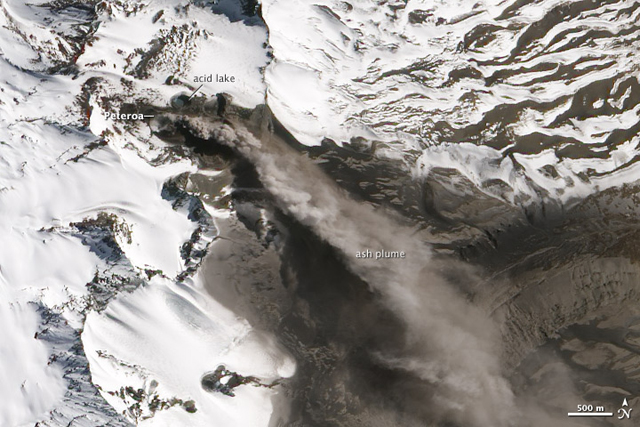 |
Figure 6. This natural-color satellite image of Peteroa crater was acquired on 21 September 2010 by the Advanced Land Imager (ALI) aboard the satellite Earth Observing-1 (EO-1). NASA Earth Observatory image and analysis by Robert Simmon, using ALI data from the NASA EO-1 team. Courtesy of NASA Earth Obseratory Natural Hazards web site. |
On 30 September, SERNAGEOMIN officials flew over the volcano and observed modest pyroclastic eruptions, emissions slightly stronger than those observed for during the previous 3 weeks. The eruptive activity remained constant from the SW crater, which discharged a relatively dense column of ash, gases, fumes, and water vapor. The emission of ash and gas was maintained from the bottom NE edge of the SW crater, but it was more continuous, dense, and vigorous than that observed during the overflight on 7 September 2010. The 30 September ash column emerged from the crater and attained a height ~400 m above the volcano, and spread to the E over a wide area in Argentina. During the 30 September overflight, observers noted a major part of ash plume distributed to the E and then bending to the NE, extending some tens of kilometers, with estimated plume-top altitudes of up to 6 km. A trace, more-dilute plume stretched to the S and SE to maximum altitudes of ~3 km.
On the morning of 1 October 2010, warm, easterly winds (called Puelche-type winds) carried ash and sulfurous smells to the town of Los Queñes (~30 km NE of the volcano). During 6-12 October ash plumes rose to altitudes of 3-6.1 km and drifted in multiple directions. Observations from Romeral and photos sent by staff from a mining company (65 km WNW) showed that plume changed from gray to white on 13 October. The plume was smaller, with heights of less than 200 m above the crater. The Alert Level 4 was continued, before being lowered to Alert Level 3 on 27 October and then to Alert Level 2 on 11 November. The MODVOLC thermal alert system had not detected any thermal anomalies since at least 2000.
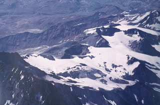
Geological Summary. Planchón-Peteroa is an elongated complex volcano along the Chile-Argentina border with several overlapping calderas. Activity began in the Pleistocene with construction of the basaltic-andesite to dacitic Volcán Azufre, followed by formation of basaltic and basaltic-andesite Volcán Planchón, 6 km to the north. About 11,500 years ago, much of Azufre and part of Planchón collapsed, forming the massive Río Teno debris avalanche, which traveled 95 km to reach Chile's Central Valley. Subsequently, Volcán Planchón II was formed. The youngest volcano, andesitic and basaltic-andesite Volcán Peteroa, consists of scattered vents between Azufre and Planchón. Peteroa has been active into historical time and contains a small steaming crater lake. Historical eruptions from the complex have been dominantly explosive, although lava flows were erupted in 1837 and 1937.
Information Contacts: Servicio Nacional de Geología y Minería (SERNAGEOMIN); Buenos Aires Volcanic Ash Advisory Center (VAAC) (URL: http://www.smn.gov.ar/vaac/buenosaires/productos.php); NASA Earth Obseratory (URL: http://earthobservatory.nasa.gov/); MODIS/MODVOLC Hot Spot web site, Hawai'i Institute of Geophysics and Planetology (HIGP) Thermal Alerts System, School of Ocean and Earth Science and Technology (SOEST), University of Hawai'i, 2525 Correa Road, Honolulu, HI (URL: http://modis.higp.hawaii.edu/).