Report on Ulawun (Papua New Guinea) — March 2011

Bulletin of the Global Volcanism Network, vol. 36, no. 3 (March 2011)
Managing Editor: Richard Wunderman.
Edited by Jen Fela.
Ulawun (Papua New Guinea) Modest eruptions included ash plumes to 4 km through February 2011
Please cite this report as:
Global Volcanism Program, 2011. Report on Ulawun (Papua New Guinea) (Fela, J., and Wunderman, R., eds.). Bulletin of the Global Volcanism Network, 36:3. Smithsonian Institution. https://doi.org/10.5479/si.GVP.BGVN201103-252120
Ulawun
Papua New Guinea
5.05°S, 151.33°E; summit elev. 2334 m
All times are local (unless otherwise noted)
This report discusses volcanism and seismicity at Ulawun between early 2010 through February 2011, a period when the volcano (figure 14) discharged several ash plumes to as high as 3-4 km altitude. In one case, ash plumes were seen in satellite imagery drifting for almost 200 km. Our previous reporting noted steam plumes and increased seismicity in February 2010 (BGVN 35:02), which followed a multi-year interval of comparative quiet (BGVN 33:03 and 34:10).
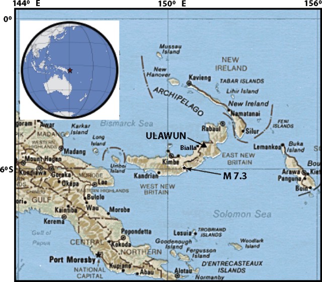 |
Figure 14. (Upper left) Index map showing Ulawun's location on New Britain Island to N of Australia. (Main map) Map of New Britain island and adjacent regions showing the epicenter of the Mw 7.3 earthquake of 18 July 2010. A more detailed map of the area appeared in a report on Likuranga volcano (BGVN 31:10). Main map specified as a 1985 edition (but authorship not found); provided by the University of Texas Library (ww.lib.utexas.edu). |
As an overview of this report, the Rabaul Volcano Observatory (RVO) noted that during May 2010, the volcano produced occasional gray plumes, incandescence, audible noises, and increased seismicity. Accordingly, RVO recommended that the hazard status be set at Stage 1 Alert (in their 4-stage alert system), where it stayed through the rest of the reporting interval. Large regional earthquakes took place in June and July 2010 (figure 14).
Activity during May-July 2010. During 1-21 May, RVO reported variable amounts of white vapor; during late May to July, emissions were darker in color, with some specific examples highlighted below. Based on analyses of satellite imagery, the Darwin Volcanic Ash Advisory Centre (VAAC) reported ash plumes during 22-25 May that drifted 35-130 km at an altitude of 3 km. During late May through late June, RVO reported that white to gray plumes rose up to 1 km high and at times ashfall occurred. RVO noted gray plumes on 22, 25, and 29 May. People on the S part of New Britain observed fluctuating incandescence on 28-29 May.
Very fine ashfall was reported on 30 May in areas to the SSW, S, and SSE. It was again reported on 3 and 8 June, ~10 km NW (in Ulamona). During 9-25 June, fine ashfall was reported almost daily on the NW, SW, and sometimes W flanks.
Between late May and early July, low roaring or rumbling noises often were reported. Fluctuating incandescence from the crater was observed at night during 28-29 May, 6-10 June, 13 June, and 16-25 June.
On 18 and 19 June, seismicity increased to a high level and was dominated by volcanic tremor. The next day, seismicity declined to a moderate level and continued to do so after 26 June.
According to the Darwin VAAC, during 1-5 July ash plumes drifted 55-195 km at an altitude of 3 km. RVO reported that, at times during late June and July, white-to-gray plumes rose up to 500 m above the volcano. During 27 June-9 July fine ash fell in areas to Ulawun's SW, W, and NW.
During 5-8 July RVO noted a slight increase in seismicity (above moderate levels), which included tremor. During 16-21 July, volcanic tremors continued, but overall seismicity declined slightly. Seismic amplitude (RSAM) values remained moderate.
RVO reported that on 23-24 July ash plumes were observed.
Large regional earthquakes. RVO reported that several large earthquakes occurred during June and July (table 4). The largest of those were the adjacent 18 July earthquakes, a foreshock of Mw 6.9 and a mainshock of Mw 7.3. The latter, which was destructive, was the largest in about a decade. The Provincial Disaster Office reported significant building damage near the epicenter and in the town of Kimbe (65 km NW of the mainshock's epicenter, figure 14). The mainshock's epicenter was also ~45 km S of Pago volcano and 134 km SW of Ulawun. Many damaged houses had been constructed of bush materials, but some houses also included modern building materials. At least one death was reported. Numerous aftershocks followed the main Mw 7.3 shock.
Table 4. Large regional earthquakes near Ulawun that occurred on the days 2, 3, and 24 June and 18 July 2010. Courtesy of RVO.
| Date | Time (local) | Mw | Type | Depth (km) | Location and comments |
| 02 Jun 2010 | 1929 | 5.8 | Regional earthquake | 80 | Offshore near Kandrian |
| 03 Jun 2010 | 1715 | -- | High-frequency volcano-tectonic earthquake | -- | Felt by island residents with Modified Mercalli (MM) intensity up to IV |
| 24 Jun 2010 | 1532 | 6.2 | Tectonic earthquake | 70-80 | In central New Britain centered~30-40 km SSE of Bialla town (70-80 km). MM Intensity of ~IV at Rabaul Town |
| 18 Jul 2010 | 2304 | 6.9 | Foreshock | 42 | Both earthquakes occurred on the S side of West New Britain Province near Gasmata. Residents felt them very strongly near the epicenter and in Kimbe area. |
| 18 Jul 2010 | 2335 | 7.3 | Mainshock | 35 | -- |
Highlights of behavior, August 2010 through February 2011. During 6-24 August, white and gray-to-brown plumes rose no more than 300 m above Ulawun, and fine ash fell on the NW and W flanks. Seismicity decreased compared to previous weeks.
During 26 November 2010, based on analyses of satellite imagery and information from RVO, the Darwin VAAC reported that an ash plume rose to an altitude of 3.7 km and drifted 55 km NE.
RVO reported that mild activity continued during 1 January through at least 28 February 2011, characterized by brown-to-gray ash plumes that rose less than 500 m. These produced fine ashfall to the SE. Sulfur dioxide plumes drifted SE on 5 and 31 January. During 23-26 February, gray ash plumes occasionally drifted NE, SW, and NW.
Geological Summary. The symmetrical basaltic-to-andesitic Ulawun stratovolcano is the highest volcano of the Bismarck arc, and one of Papua New Guinea's most frequently active. The volcano, also known as the Father, rises above the N coast of the island of New Britain across a low saddle NE of Bamus volcano, the South Son. The upper 1,000 m is unvegetated. A prominent E-W escarpment on the south may be the result of large-scale slumping. Satellitic cones occupy the NW and E flanks. A steep-walled valley cuts the NW side, and a flank lava-flow complex lies to the south of this valley. Historical eruptions date back to the beginning of the 18th century. Twentieth-century eruptions were mildly explosive until 1967, but after 1970 several larger eruptions produced lava flows and basaltic pyroclastic flows, greatly modifying the summit crater.
Information Contacts: Rabaul Volcano Observatory (RVO), P.O. Box 386, Rabaul, Papua New Guinea; Darwin Volcanic Ash Advisory Centre (VAAC), Commonwealth Bureau of Meteorology, Northern Territory Regional Office, PO Box 40050, Casuarina, NT 0811, Australia (URL: http://www.bom.gov.au/info/vaac/).