Report on Colima (Mexico) — March 2011

Bulletin of the Global Volcanism Network, vol. 36, no. 3 (March 2011)
Managing Editor: Richard Wunderman.
Colima (Mexico) Dome growth continues in 2010-2011; eroding, ~55-m-long lobe
Please cite this report as:
Global Volcanism Program, 2011. Report on Colima (Mexico) (Wunderman, R., ed.). Bulletin of the Global Volcanism Network, 36:3. Smithsonian Institution. https://doi.org/10.5479/si.GVP.BGVN201103-341040
Colima
Mexico
19.514°N, 103.62°W; summit elev. 3850 m
All times are local (unless otherwise noted)
The Observatorio Vulcanologico de la Universidad de Colima (Colima Volcanological Observatory) reported that during 2010-2011, lava extrusion at Colima continued at the dome that was first recognized in February 2007. The slow growth of a small lobe of lava within the W sector of the crater of the volcano commenced during February 2010 (BGVN 35:05), and this process continued through March 2011. The rate of growth of this lobe was ~0.1 m3/s, and was accompanied by numerous rockfalls and small explosions (figures 97 and 98). Explosions often remained in the range of 3 to 15 per day during January 2009 through March 2011. As previously noted (BGVN 35:05), rockfalls suddenly became very common in February 2010. The rockfalls reached a maximum of over 60 per day, and through March 2011 they remained in the range of 15 to 42 per day (figure 97).
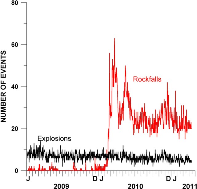 |
Figure 97. Variations in the daily number of small explosions and rockfalls at Colima during the year of 2009 through March 2011 based on the observations of the seismic network RESCO (seismic station EZV4, 1.7 km from Colima's crater). Courtesy of Colima Volcano Observatory. |
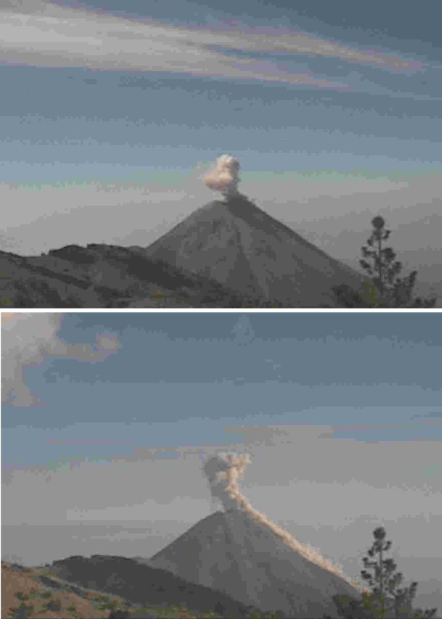 |
Figure 98. Low-resolution images characterizing behavior at Colima during the year 2010 into March 2011, where small explosions at the summit dome were soon followed by rockfalls. Both photos taken by the web camera at station Nevado, located at elevation 4 km on the neighboring peak (Nevado de Colima) 6 km N of the active dome and crater. Courtesy of Colima Volcano Observatory. |
The active lobe's width was ~10-15 m; its length was ~50-60 m. Loss of material from the lobe's distal end generated frequent rockfalls. According to a report from the Observatory, " . . . extrusive activity of the volcano has changed from endogenic [i.e., intrusion within the dome], observed during 2007-2009, to exogenic [i.e., extrusion to the dome's surface or margin] with the development of the new lava lobe." Figure 99 illustrates this change in the eruptive process (endogenic in the upper frame, switching to exogenic).
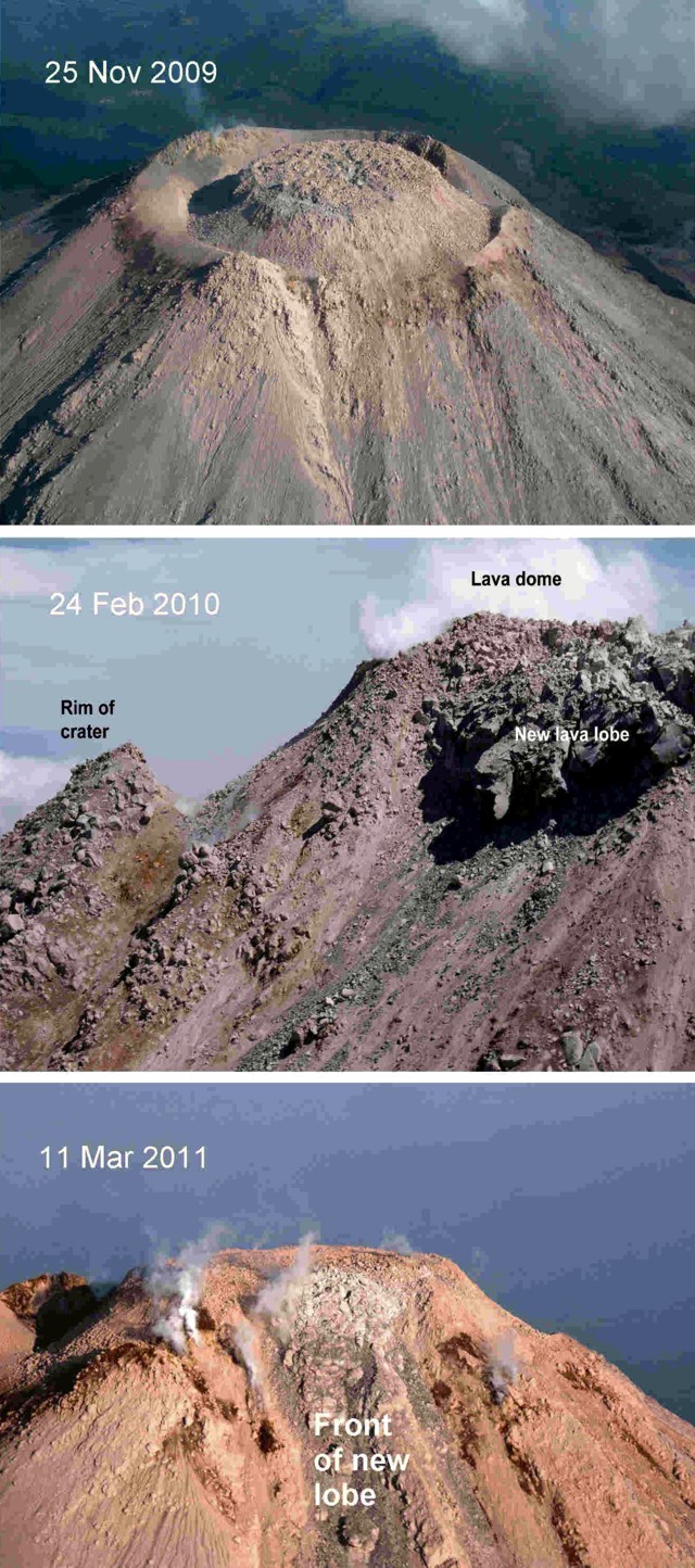 |
Figure 99. Photos of the Colima's crater zone taken (top to bottom) on 25 November 2009, 24 February 2010, and 11 March 2011. All three are views from the volcano's W side. The photos document a new lava lobe (24 February 2010) and its development to 11 March 2011. Courtesy of Civil Protection of the State of Jalisco. |
Satellite image, January 2011. A natural-color satellite image of Colima was acquired 22 January 2011 (figure 100). The perspective of the image (straight down) flattens the appearance of the classic steep-sided stratovolcano, according to the image's NASA Earth Observatory analysts. Similarly, they noted that the image's relatively low resolution (10 m per pixel) falsely gives a smooth appearance to what are actually very rough-surfaced block lava flows.
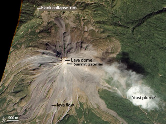 |
Figure 100. This natural-color satellite image of Colima was acquired on 22 January 2011 by the Advanced Land Imager (ALI) on Earth Observing-1 (EO-1). N is to the top. The region titled 'flank-collapse rim' represents the topographic margin of an ancient collapse (see text). Courtesy of NASA Earth Observatory. |
The image in figure 100 shows evidence of four types of volcanic activity: lava dome growth, explosive eruptions, flank collapse, and lava flows. The active lava dome nearly fills Colima's summit crater. The top of the dome is higher than the crater rim, and material occasionally tumbles down the volcano's W and S slopes. A light colored plume, probably dust from rockfalls off the dome, extends to the E (right) of the summit. Colima's summit crater developed during a 1913 explosive eruption that removed 100 m off the summit.
To the N of Colima's summit is a rim ('flank-collapse rim') of a 5-km-wide caldera, formed about 4,300 years ago in a massive flank collapse, similar to the 18 May 1980 eruption of Mount St. Helens. Modern Colima volcano rises near the center of this caldera. Recent lava flows (erupted since 1961), cover the upper slopes of the volcano. Older lava flows (erupted in the 1800s and earlier) are covered in green vegetation.
MODVOLC. The MODVOLC satellite thermal alerts system showed thermal alerts of 4 pixels at 0845 UTC on 29 December 2010 and 2 pixels at 0520 UTC on 20 January 2011, confirming recent hot material at and near the dome. Press reports also noted incandescent lava flows. The alerts mentioned above were the only significant ones measured since 2005, when major explosions occurred (BGVN 30:06 and 31:03).
Geological Summary. The Colima complex is the most prominent volcanic center of the western Mexican Volcanic Belt. It consists of two southward-younging volcanoes, Nevado de Colima (the high point of the complex) on the north and the historically active Volcán de Colima at the south. A group of late-Pleistocene cinder cones is located on the floor of the Colima graben west and east of the complex. Volcán de Colima (also known as Volcán Fuego) is a youthful stratovolcano constructed within a 5-km-wide scarp, breached to the south, that has been the source of large debris avalanches. Major slope failures have occurred repeatedly from both the Nevado and Colima cones, producing thick debris-avalanche deposits on three sides of the complex. Frequent recorded eruptions date back to the 16th century. Occasional major explosive eruptions have destroyed the summit (most recently in 1913) and left a deep, steep-sided crater that was slowly refilled and then overtopped by lava dome growth.
Information Contacts: Observatorio Vulcanologico de la Universidad de Colima (Colima Volcanological Observatory), Calle Manuel Payno, 209 Colima, Col., 28045 Mexico (URL: http://www.ucol.mex/volc/); NASA Earth Observatory (URL: http://earthobservatory.nasa.gov/); Hawai'i Institute of Geophysics and Planetology (HIGP) MODVOLC Thermal Alerts System, School of Ocean and Earth Science and Technology (SOEST), Univ. of Hawai'i, 2525 Correa Road, Honolulu, HI 96822, USA (URL: http://modis.higp.hawaii.edu/).